James Spann: Rain returns to Alabama Tuesday night/Wednesday
James Spann: Dry day for Alabama, but more rain on its way this week from Alabama NewsCenter on Vimeo.
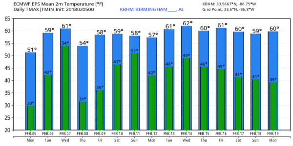
COOL, DRY MONDAY: Temperatures are mostly in the 30s across the northern half of Alabama this morning; with a good supply of sunshine today we project a high in the low 50s by afternoon. Clouds increase tonight, and we should stay above freezing with temperatures in the low 40s early tomorrow.
RAIN RETURNS: Tomorrow will be mostly cloudy with a high in the low 60s, and while a shower is possible in spots by afternoon, the better chance of rain returns tomorrow night into Wednesday. The latest model data shows little surface-based instability and fairly weak wind fields, so for now the Storm Prediction Center is not showing any chance of organized severe thunderstorms. It looks like another beneficial rain event for the state, with amounts of 1 to 2 inches likely.
THURSDAY/FRIDAY: These two days look dry with ample sunshine; the high will be in the mid 50s Thursday, followed by low 60s Friday. Clouds increase Friday night with a few showers possible.
THE ALABAMA WEEKEND: The weekend looks wet as the active weather pattern continues. We will mention a good chance of showers and thunderstorms both Saturday and Sunday ahead of a slow-moving cold front; it won’t rain the entire weekend, but be ready for occasional showers and a heavy downpour at times. Temperatures will be fairly mild for February, with highs in the 60s both days. For now, instability looks very limited, so severe storms don’t look especially likely. Rain amounts over the weekend once again will be in the 1- to 2-inch range.
NEXT WEEK: Monday and Tuesday look dry, but more showers are possible over the latter half of the week as moisture levels rise again. No sign of any Arctic air; highs will be in the 50s and 60s through the week. And there’s no sign of any snow or ice issues for Alabama for the next seven to 10 days.
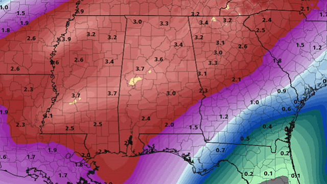
BIG SOAKING THIS PAST WEEKEND: Storm totals from the weekend include 3.03 inches at Chelsea, 2.61 inches at Cottondale, 2.58 inches at Coker, 2.19 inches at Bessemer, 2.14 inches at Hueytown, 2.04 inches at Mountain Brook, 1.76 inches at Weaver, 1.55 inches at Centre and 1.32 inches at Rainbow City.
ON THIS DATE IN 2008: A total of 87 tornadoes occurred over the course of the “Super Tuesday” tornado outbreak, which lasted more than 15 hours from the afternoon of Feb. 5 until the early morning of Feb. 6. The storm system produced several destructive tornadoes in heavily populated areas, most notably in the Memphis metropolitan area, in Jackson, Tennessee, and the northeastern end of the Nashville metropolitan area. In Alabama, an EF-4 tornado moved through parts of Lawrence and Morgan counties, killing three people near Moulton during the pre-dawn hours of Feb. 6. Another EF-4 moved through the Rosalie and Pisgah communities, killing one person there.
BEACH FORECAST: Click here to see the AlabamaWx Beach Forecast Center page.
WEATHER BRAINS: You can listen to our weekly 90-minute netcast anytime on the web, or on iTunes. This is the show all about weather featuring many familiar voices, including meteorologists at ABC 33/40. We will produce this week’s show tonight at 8:30. You can watch it live here.
CONNECT: You can find me on all of the major social networks:
Facebook
Twitter
Google Plus
Instagram
Pinterest
Snapchat: spannwx
For more weather news and information from James Spann and his team, visit AlabamaWx.


