James Spann: Scattered showers today in Alabama; more widespread rain tonight
James Spann: Alabama gets wet today, but no severe weather from Alabama NewsCenter on Vimeo.
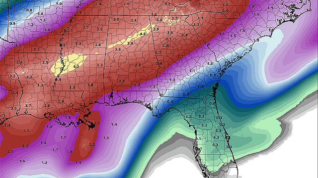
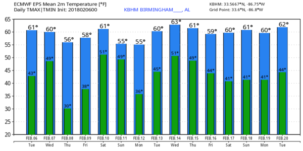
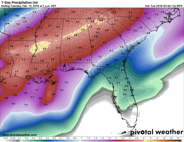
RADAR CHECK: Scattered showers are moving eastward across central Alabama early this morning; the sky is cloudy and temperatures are mostly in the 40s at daybreak. Mostly cloudy conditions will continue throughout the day, with temperatures rising into the low 60s this afternoon. We will maintain the chance of scattered showers, but the more widespread rain comes late tonight into tomorrow morning with a slow-moving cold front approaching. Looks like another beneficial rain event for the state with amounts in the 1- to 2-inch range for most places.
The Storm Prediction Center is carrying a marginal risk of severe storms in its forecast for areas west of Alabama today, but it does not have any risk defined tomorrow as instability values look too low and wind fields too weak for organized severe weather issues. But a few rumbles of thunder are likely early tomorrow morning.
The heaviest rain should move down into the southern part of Alabama by mid-morning tomorrow, but a few isolated showers could linger into the afternoon. There’s a good chance the high tomorrow will come during the morning; we will fall from near 60 tomorrow morning, through the 50s, and possibly into the 40s by mid to late afternoon.
THURSDAY/FRIDAY: Thursday will be dry with seasonal temperatures and a good supply of sunshine; we start the day near freezing, then rise into the mid 50s by afternoon. Friday will feature a mix of sun and clouds, and while most of the day will be dry, we will introduce the risk of a few scattered afternoon showers as moisture levels rise. Temperatures rise into the low 60s Friday afternoon.
THE ALABAMA WEEKEND: The weather for Saturday and Sunday looks mild and wet. Highs both days will be in the 60s, and we will need to forecast occasional showers and thunderstorms. There will be breaks in the rain, and for now we don’t expect any severe thunderstorm issues. But again beneficial rain is expected, with amounts of 1 to 2 inches by Sunday night.
NEXT WEEK: There could be enough moisture around for a few scattered showers Monday and Tuesday, but nothing really organized. A surface front could bring an increase in showers by Wednesday. The week looks mild with highs mostly in the 60s as the upper air flow will keep the really cold air bottled up over the northern U.S.
RAIN UPDATE: Birmingham’s rain total for the year is now 3.27 inches, still 2.38 inches below average. But the pattern favors frequent rain producers for the rest of February, and it should knock out that deficit.
BEACH FORECAST: Click here to see the AlabamaWx Beach Forecast Center page.
WEATHER BRAINS: You can listen to our weekly 90-minute netcast anytime on the web, or on iTunes. This is the show all about weather featuring many familiar voices, including meteorologists at ABC 33/40.
CONNECT: You can find me on all of the major social networks:
Facebook
Twitter
Google Plus
Instagram
Pinterest
Snapchat: spannwx
For more weather news and information from James Spann and his team, visit AlabamaWx.


