James Spann: Rain tapers off later today in Alabama as temperatures fall
James Spann: Marginal risk of severe weather in Alabama today from Alabama NewsCenter on Vimeo.
LOUD EARLY MORNING STORMS: A band of thunderstorms with torrential rain and gusty winds has been moving through north and central Alabama early this morning. The heaviest rain is now south of I-20.
Heavier rain will push into the southern half of the state in coming hours, where the Storm Prediction Center maintains a marginal risk of severe thunderstorms. The main threats are from gusty thunderstorm winds and small hail; the tornado threat is very low, but not zero.
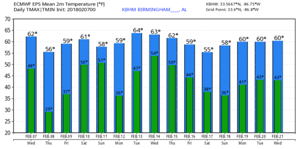
For the northern half of Alabama, rain tapers off later this morning, and temperatures will be going the wrong way. We are starting the day with low 60s in many places, but by afternoon we drop into the 40s with lingering clouds and a chilly northwest wind. The sky becomes clear tonight, and we will see a low near 30 degrees early tomorrow morning.
TOMORROW/FRIDAY: Sunshine returns in full force tomorrow; after the chilly start we expect a high in the upper 50s. Friday will feature a partly sunny sky with a high in the low to mid 60s; we will mention a small risk of an afternoon shower as moisture levels begin to rise, but most of the day should be dry.
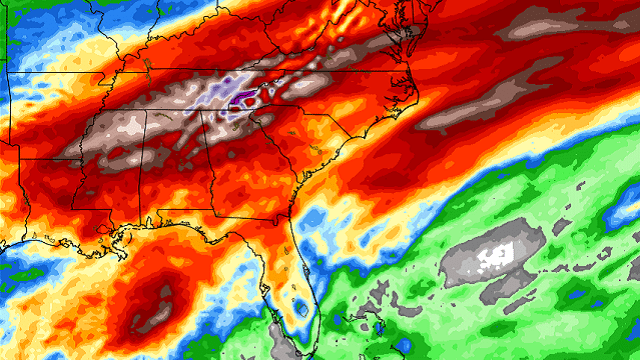
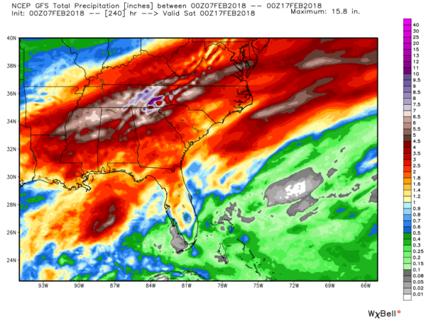
RAIN RETURNS OVER THE WEEKEND: Clouds thicken Friday night, and we will need to mention occasional showers and thunderstorms Saturday and Sunday as a very moist air mass sets up across the Deep South. We aren’t able to tell you exactly when the rain will start and stop, but if you have something going on outdoors, be ready for rain or a thunderstorm at just about any time over the weekend. There will be breaks in the rain, and temperatures will be comfortable with highs in the 60s; a few spots could touch 70 degrees Sunday afternoon. Rain amounts over the weekend will be in the 1- to 2-inch range, and the threat of severe storms for now looks low.
NEXT WEEK: Moisture will linger, and we will need to extend the chance of showers into the first half of the week. Temperatures will stay mild for February, with highs generally in the 60s. The pattern looks very favorable for beneficial rain across the Southeast over the next 10 days.
There’s no sign of any Arctic air or bitterly cold temperatures for the next 10-15 days.
BEACH FORECAST: Click here to see the AlabamaWx Beach Forecast Center page.
WEATHER BRAINS: You can listen to our weekly 90-minute netcast anytime on the web, or on iTunes. This is the show all about weather featuring many familiar voices, including meteorologists at ABC 33/40.
CONNECT: You can find me on all of the major social networks:
Facebook
Twitter
Google Plus
Instagram
Pinterest
Snapchat: spannwx
For more weather news and information from James Spann and his team, visit AlabamaWx.


