James Spann: Rain, storms return to Alabama late tonight, Thursday
ACTIVE WEATHER AHEAD: The weather is pretty quiet across Alabama this afternoon; the sky is generally cloudy, but the sun has popped out at times, pushing temperatures into the upper 70s. We have a few widely scattered showers on radar over northwest Alabama, but nothing widespread or heavy.
Rain and storms will increase after midnight tonight through the day tomorrow as a cold front approaches. The Storm Prediction Center continues to mention some risk of strong to severe storms over much of the state tomorrow.

TIMING: While showers and storms are possible at just about any hour tomorrow, the heavier storms will most likely come during the midday and afternoon, when the air is most unstable — in the 11 a.m. to 6 p.m. time frame.
THREATS: The main threats will come from strong straight-line winds and small hail. Some notes from the SPC: “With strong southwesterly flow aloft aiding potential for convective organization, potential for damaging winds is evident. A brief tornado or two may also occur, within the evolving complex/broken convective line where potential for an embedded/rotating updraft or two may exist. Risk should diminish by evening, as the airmass stabilizes diurnally.”
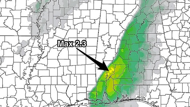
We stress this event is nothing like March 19, when 15 tornadoes touched down across Alabama and destructive hail, up to 5 inches in diameter, created much damage. The Significant Tornado Parameter (STP) peaked at 7 on March 19; the high-resolution North American Mesoscale shows an STP peak tomorrow of 2.3 over southwest Alabama.
 Still, we need to watch any system like this carefully that passes through in late March.
RAIN AMOUNTS: A flood watch is in effect for just three counties in the far northwest corner of Alabama — Lauderdale, Colbert and Franklin. This is where rain amounts of 2 to 3 inches are expected. For the rest of the state, we project around 1 inch with no flooding expected.
FRIDAY AND THE WEEKEND: The sky becomes sunny Friday with a high in the 60s, and the Easter weekend looks very nice. Saturday will feature ample sunshine with a high in the mid 70s, and Sunday will be mild and dry; the sky will be partly sunny with a high back in the 70s. A few isolated showers are possible Sunday near the Tennessee border, but most of the state will be dry.
NEXT WEEK: The latest global model data suggests that any showers Monday and Tuesday will be very widely spaced; the high will be in the 77- to 80-degree range. Showers will increase by Wednesday and Thursday with a cold front approaching from the north.

BEACH FORECAST: Click here to see the AlabamaWx Beach Forecast Center page.
WEATHER BRAINS: You can listen to our weekly 90-minute netcast any time on the web or on iTunes. This is the show all about weather featuring many familiar voices, including meteorologists at ABC 33/40.
CONNECT: You can find me on all of the major social networks:
Facebook
Twitter
Google Plus
Instagram
Pinterest
Snapchat: spannwx
For more weather news and information from James Spann and his team, visit AlabamaWx.


