James Spann: Strong/severe storms move through Alabama Tuesday night
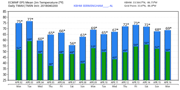
WARM/DRY AFTERNOON: Temperatures are in the 76- to 80-degree range across Alabama this afternoon with a mix of sun and clouds. The sky becomes mostly cloudy tonight as moisture levels rise.
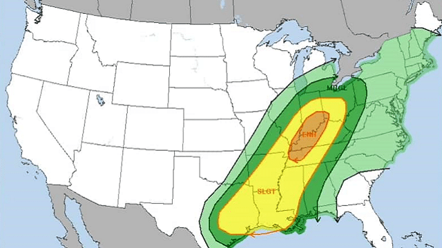
STRONG STORMS TUESDAY NIGHT: The day Tuesday will be mostly cloudy, breezy and mild, with only an outside risk of a shower. An organized line of showers and storms will move into the state late Tuesday night ahead of a cold front. The Storm Prediction Center maintains a slight risk of severe storms over northwest Alabama — west of a line from Huntsville to Jasper to Aliceville. A marginal risk extends down to Heflin, Prattville and Atmore.
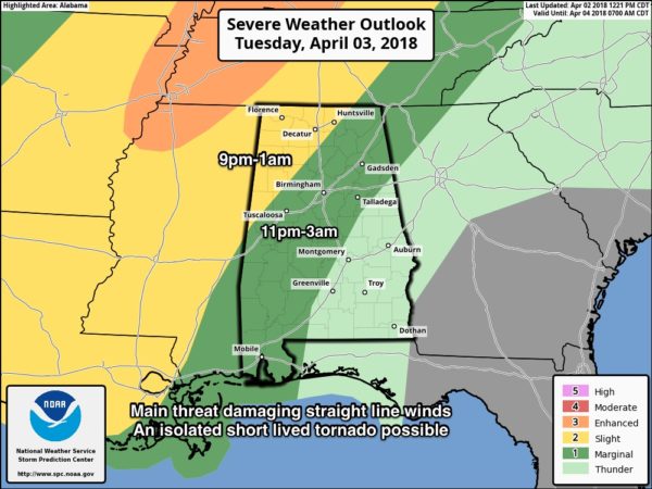
TIMING: The core threat for northwest Alabama will come from 9 p.m. to 1 a.m.; for places like Birmingham, Tuscaloosa, Anniston and Gadsden, the main threat is from 11 p.m. to 3 a.m.
THREATS: The main issue will be from strong, potentially damaging straight-line winds, but we can’t rule out one or two short-lived tornadoes, especially in northwest Alabama. Some small hail is possible as well.
RAIN AMOUNTS: Rain amounts for most places will be in the one-half-inch to three-quarters-inch range. No flooding is expected.
The sky becomes sunny Wednesday as much cooler and drier air returns; the high Wednesday will be in the 60- to 65-degree range.
FROST THREAT EARLY THURSDAY: We are still expecting lows for most places early Thursday morning in the mid 30s with a good chance of frost. Traditionally colder spots will see another late-season freeze. The day Thursday will be sunny with a high close to 70 degrees.
FRIDAY AND THE WEEKEND: Clouds return Friday along with the risk of a few showers. It won’t rain all day, and the afternoon high will be in the 67- to 70-degree range. A surface front will stall over south Alabama late Friday night and Saturday, and rain should become more widespread across Alabama as the weekend begins. We will forecast periods of rain Saturday with temperatures holding in the cool 50s, almost 20 degrees below average for early April.
Sunday will be warmer, with a high in the mid 70s as the warm front lifts northward; new model data suggests a decent part of the day will be dry with only isolated showers.
NEXT WEEK: Monday looks mostly dry and mild, with a high in the 70s. Then showers and storms return Tuesday, possibly into Wednesday, followed by another shot of colder air.
BEACH FORECAST: Click here to see the AlabamaWx Beach Forecast Center page.
WEATHER BRAINS: You can listen to our weekly 90-minute netcast any time on the web or on iTunes. This is the show all about weather featuring many familiar voices, including meteorologists at ABC 33/40.
CONNECT: You can find me on all of the major social networks:
Facebook
Twitter
Google Plus
Instagram
Pinterest
Snapchat: spannwx
For more weather news and information from James Spann and his team, visit AlabamaWx.


