James Spann: Dry Wednesday, rainy Thursday ahead for Alabama
RADAR CHECK: We have scattered showers across north and central Alabama this afternoon as we remain under the influence of an upper low to the north. These showers will dissipate once the sun goes down.

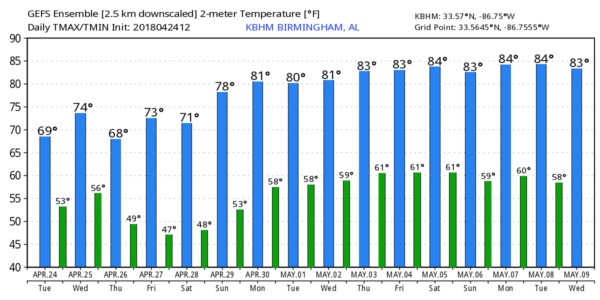
Temperatures are in the mid to upper 60s, well below average for late April in Alabama.
REST OF THE WEEK: Wednesday will be dry with a mix of sun and clouds; the high will be in the low 70s for most communities. Clouds thicken Wednesday night, and Thursday looks wet, with occasional rain throughout the day. We won’t get out of the 60s Thursday because of clouds and rain. On Friday we expect some sun during the day, but a few showers are possible Friday afternoon and Friday evening ahead of an approaching cold front. Moisture will be pretty limited, and rain amounts should be light.
THE ALABAMA WEEKEND: For the first time in a while, we won’t have to dodge raindrops. Expect sunshine in full supply Saturday and Sunday; the high Saturday will be in the low 70s, followed by upper 70s Sunday.
RACE WEEKEND: Thursday looks pretty wet at the Talledega Superspeedway, with periods of rain likely and a high in the 60s. For Friday, we expect just a few widely scattered afternoon and evening showers; the high will be close to 70 degrees. Then, the weather could not be better for the weekend — sunny Saturday and Sunday, with highs in the low 70s Saturday followed by upper 70s Sunday for the Geico 500.
NEXT WEEK: An upper high builds across the eastern U.S., and the first half of the week looks warm and dry with highs in the low 80s. A few scattered showers or storms are possible later in the week as moisture levels rise, but the chance of any severe weather looks low thanks to the persistent ridge.
ON THIS DATE IN 2010: A number of tornadoes touched down across the northern half of Alabama. One was an EF-3 that first touched down 4 miles northeast of Brooksville in Blount County around 10 that night. It then moved northeast into southern Marshall County. The most significant and widespread damage along its path occurred in the city of Albertville between 10:27 p.m. and 10:40 p.m., affecting numerous residences, the Albertville high school and several large retail buildings. In the town of Geraldine, numerous large trees were snapped or uprooted, which also led to some structural damage to residences. The tornado lifted near the Pine Ridge community just west of Fort Payne. The path length of the tornado was estimated at 41 miles with a maximum path width of three-quarters of a mile.
BEACH FORECAST: Click here to see the AlabamaWx Beach Forecast Center page.
WEATHER BRAINS: You can listen to our weekly 90-minute netcast any time on the web or on iTunes. This is the show all about weather featuring many familiar voices, including meteorologists at ABC 33/40.
CONNECT: You can find me on all of the major social networks:
Facebook
Twitter
Google Plus
Instagram
Pinterest
Snapchat: spannwx
For more weather news and information from James Spann and his team, visit AlabamaWx.


