James Spann: Rain, and maybe a few storms, for Alabama Thursday
PLEASANT SPRING AFTERNOON: Temperatures are mostly in the low 70s across Alabama this afternoon with a partly sunny sky over the northern counties of the state. There’s nothing on radar here, but we note a strong upper trough northwest of the state that will bring rain back to Alabama.
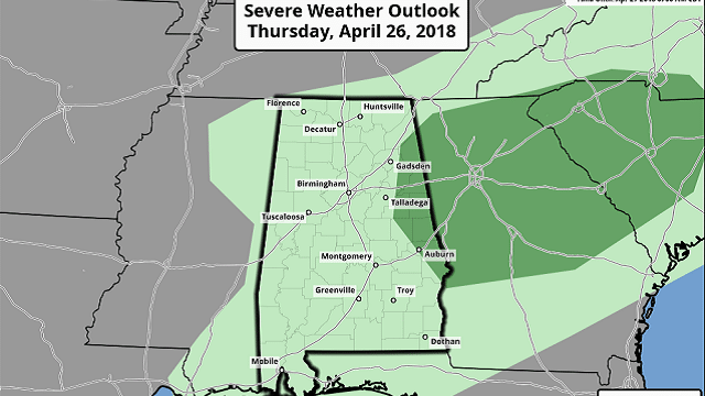
STRONG STORMS FOR EAST ALABAMA THURSDAY: Rain will arrive after midnight tonight over northwest Alabama and will be widespread over most of the state during the morning Thursday. The Storm Prediction Center has introduced a marginal risk of severe storms for the far eastern part of the state, as new model data suggests sufficient instability for a few strong thunderstorms there Thursday afternoon.

The main threat in that area will come from hail and strong, gusty winds Thursday afternoon; the tornado threat is low, but not zero. Rain amounts should be in the one-half-inch to 1-inch range, and temperatures will be in the 60s most of the day. Some east Alabama communities could reach the low 70s.
FRIDAY AND THE WEEKEND: A cold front will pass through Friday evening, but moisture will be pretty much depleted, and the chance of any one spot seeing a shower looks pretty low at this point. We expect a mix of sun and clouds Friday with a high in the low 70s. Then, a very nice surge of dry air rolls in here for the weekend. Look for sunshine in full supply Saturday and Sunday with highs in the 70s. For the first time in a while, we won’t have to dodge raindrops this weekend.
RACE WEEKEND: Thursday looks pretty wet at the Talledega Superspeedway, with rain likely during the morning and possibly a strong thunderstorm during the afternoon. Friday should be mostly dry with only a small risk of an afternoon shower; the high will be close to 70 degrees. Then, the weather could not be any better for the weekend — sunny Saturday and Sunday, with highs in the low 70s Saturday followed by mid 70s Sunday for the Geico 500.
NEXT WEEK: A strong upper ridge will build over the eastern third of the nation and will bring warm and dry weather to the state most of the week, with highs in the low 80s. A front will bring a risk of showers, and possibly a thunderstorm late in the week on Friday, May 4, but the ridge holds and for now severe weather looks unlikely.

ON THIS DATE SEVEN YEARS AGO: The four-day “superoutbreak” of tornadoes — April 25-28, 2011 — began. By the evening of April 25, multiple tornadoes had been reported across a few states west of Alabama, some of which caused significant damage in Arkansas. An intense supercell thunderstorm tracked near the Little Rock area and a tornado emergency was declared for the city of Vilonia. A large EF2 wedge tornado struck the town, subsequently causing severe damage and killing four people. A strong EF3 tornado had also struck the Hot Springs Village area earlier that evening; that tornado caused severe damage and resulted in one death. Later that evening, Another EF2 tornado caused extensive damage to both a school building and Little Rock Air Force Base as well. A total of 42 tornadoes and four tornado-related deaths were confirmed on the 25th.
BEACH FORECAST: Click here to see the AlabamaWx Beach Forecast Center page.
WEATHER BRAINS: You can listen to our weekly 90-minute netcast any time on the web or on iTunes. This is the show all about weather featuring many familiar voices, including meteorologists at ABC 33/40.
CONNECT: You can find me on all of the major social networks:
Facebook
Twitter
Google Plus
Instagram
Pinterest
Snapchat: spannwx
For more weather news and information from James Spann and his team, visit AlabamaWx.


