James Spann: Humid air hangs around Alabama, bringing more showers, storms
James Spann gives the weather outlook for the week from Alabama NewsCenter on Vimeo.
MOIST AIR GOING NOWHERE: Saying we have “moist, unstable air” in place over Alabama is nothing unusual for late May. In fact, we are in that time of the year when maritime tropical air pretty much stays parked over the Deep South. As the mid-latitude westerly winds shift northward in summer, we just don’t see many intrusions of dry continental air through early September.
And, with moist, unstable air in place, that means we will have the risk of scattered showers and thunderstorms daily through the rest of the week. Most of them will come between noon and midnight. They form in random places, meaning it is impossible to tell you in advance exactly when and where they pop up; you just have to watch radar trends. And with light winds aloft they won’t move quickly, meaning some places will see heavy amounts of rain.
Heavier storms will also produce gusty winds; they have the potential for a “wet microburst” in a few spots — stronger straight winds that can take down a few trees. But the main threat with summer storms is the lightning output. Afternoon highs will be mostly in the 80s through Friday with a mix of sun and clouds each day.
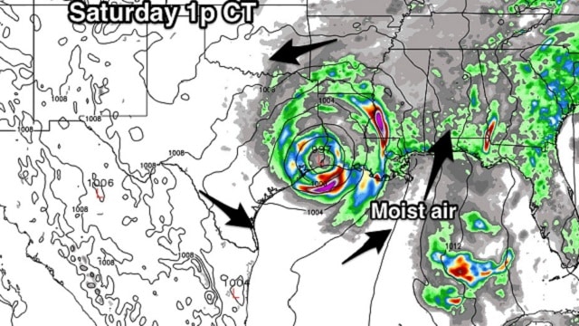
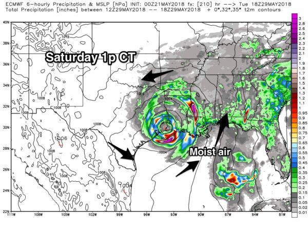
MEMORIAL DAY WEEKEND: The overall weather just won’t change much — some sun, and at least scattered showers and storms Saturday through Monday. But we will keep an eye on the Gulf of Mexico, where global models continue to suggest some potential for a tropical low. The European model (ECMWF) shows a low near the Louisiana coast Saturday; it keeps it in the same region through Monday. One way or another, it sure looks like high precipitable water values will remain over Alabama through the weekend.
This is not a situation where it just rains all day, but from time to time you will deal with a passing shower or storm each day Saturday through Monday. The sun will be out at times, and highs will remain in the 80s.
GULF COAST THIS WEEKEND: Expect about 2-4 hours of sunshine daily on the Gulf Coast (Gulf Shores east to Panama City Beach) with scattered to numerous showers and thunderstorms. If the tropical low forms, the surf could be very rough. Click here to see the AlabamaWx Beach Forecast Center page.
NEXT WEEK: There’s nothing to suggest the weather changes much next week. A broad upper trough remains over the region along with moist air, meaning scattered showers and storms will be around each day with highs in the 80s.

WEATHER BRAINS: You can listen to our weekly 90-minute netcast any time on the web, or on iTunes. This is the show all about weather featuring many familiar voices, including meteorologists at ABC 33/40. We will produce this week’s show tonight at 8. You can watch it live here.
CONNECT: You can find me on all of the major social networks:
Facebook
Twitter
Google Plus
Instagram
Pinterest
Snapchat: spannwx
For more weather news and information from James Spann and his team, visit AlabamaWx.


