James Spann: Tropical moisture hangs around Alabama
RADAR CHECK: At mid-afternoon, showers and storms are fairly widespread over the eastern half of Alabama; there is little movement, and some places are getting heavy amounts of rain. Showers have been limited over the western counties of the state so far, but they could develop there at any time through tonight. Temperatures are in the 70s and 80s.

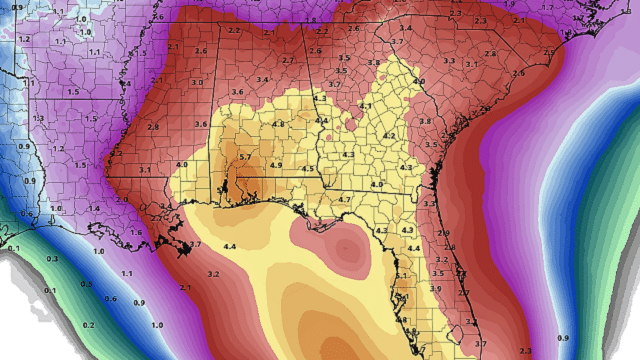
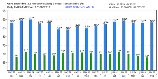
WEDNESDAY THROUGH FRIDAY: The weather won’t change much as very moist air continues to hang over Alabama. On these three days we project a mix of sun and clouds with scattered showers and thunderstorms, most active during the afternoon and evening hours. But, with high precipitable water values, we can’t rule out a late-night or morning shower. Highs will be in the 80s.
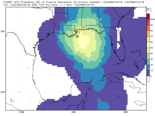
TROPICAL TROUBLE FOR THE WEEKEND? Global models continue to develop a tropical low over the northern Gulf of Mexico as the holiday weekend begins. And we still have considerable differences between the American model (GFS), which pushes a very broad low up along the west coast of Florida and then northwest in Alabama, and the European model (ECMWF), which pushes a slightly deeper low into southeast Louisiana and basically leaves it there through Monday. One way or another, the main impact will be increased rain coverage for the Gulf Coast states.

Despite this, we will have some decent breaks in the rain over the three-day weekend, and the sun could peek out at times. But expect occasional showers and possibly a thunderstorm in spots. Highs will be in the 80- to 85-degree range.
WEEKEND WEATHER ON THE GULF COAST: Here are the key points concerning weather on the coast this weekend from Panama City Beach west to Gulf Shores:
- Odds of the low in the Gulf becoming a dangerous tropical storm or hurricane are very low. Most likely, it will simply be a broad low, or a tropical depression.
- The main concern from the Gulf low is rain, not wind. Rain could be heavy in spots, and some flooding is possible.
- Because of model uncertainty, it is still too early to be specific about where the axis of heavier rain will be on the coast. On the positive side, I do think there will be a limited amount of sun for most coastal communities during the three-day weekend, and some decent breaks in the rain.
- Rip currents will become a problem; be sure and watch for the warning flags flying on the coast, and don’t go in the water if you see red flags. The risk is not worth it.
Click here to see the AlabamaWx Beach Forecast Center page.
NEXT WEEK: The tropical low will meander around and dissipate, but the moist air sticks around, meaning Tuesday through Friday will be warm, humid days with a mix of sun and clouds along with the continued dose of scattered showers and storms. Highs will be in the 80s.
SPRING TORNADO SEASON WRAPS UP: On a positive note, based on the forecast upper-air pattern I think we can stick a fork in the spring tornado season for Alabama. There’s no risk of tornadoes through the rest of May, unless the tropical system in the Gulf brings a small spin up somewhere down south (which at this point looks unlikely). Typically the only tornado threat in Alabama in summer comes from tropical systems moving up from the south, and they tend to be fairly weak and short-lived.
ON THIS DATE IN 2011: An EF5 tornado ravaged Joplin, Missouri; there were 158 fatalities and more than 1,000 injuries. It remains the deadliest tornado since modern record-keeping began in 1950 and ranked seventh among the deadliest tornadoes in history.
WEATHER BRAINS: You can listen to our weekly 90-minute netcast any time on the web, or on iTunes. This is the show all about weather featuring many familiar voices, including meteorologists at ABC 33/40.
CONNECT: You can find me on all of the major social networks:
Facebook
Twitter
Google Plus
Instagram
Pinterest
Snapchat: spannwx
For more weather news and information from James Spann and his team, visit AlabamaWx.


