Brian Peters: Alabama weather looks unsettled into July
Brian Peters has the weekend weather forecast for Alabama from Alabama NewsCenter on Vimeo.
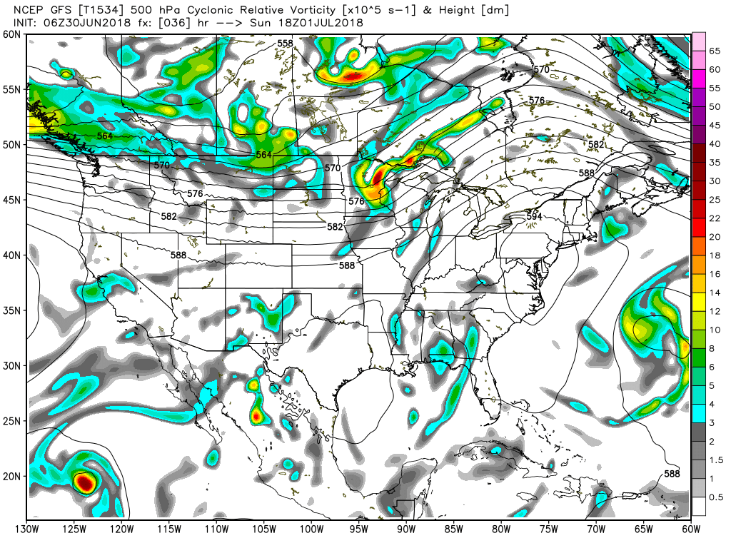
THUNDERSTORMS ON THE RISE AGAIN: What a change between Thursday and Friday! But it looks like the number and coverage of thunderstorms will go up this weekend and continue into the first of next week. I’m not expecting anything like last Thursday, but with the presence of a weak area of low pressure aloft along with afternoon heating, thunderstorms should be somewhat numerous across central and south Alabama. The sky across the state was clear this morning, with only a few clouds. Radar was clear for Alabama, but the regional radar view showed a few showers lingering across the northeast Gulf and southwest Georgia this morning helping to identify the weak disturbance seen on the 500 millibar chart. Highs today should again reach the 88 to 92 range for central Alabama with fairly numerous showers, especially along and south of the Interstate 20 corridor.
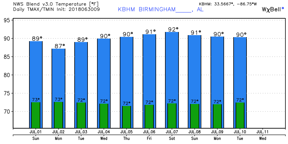
THE WEEK AHEAD: The weak upper-level low pressure area is forecast to drift slowly westward over the next couple of days, reaching the lower Mississippi River Valley by Tuesday. With this feature to our west the number and coverage of showers should be reduced, with only scattered showers expected and highs remaining in the lower 90s. Unfortunately the precipitable water values remain relatively high, so we’ll have to remain vigilant about heat indices through the week ahead, but right now it appears that those values should remain below the criteria for a heat advisory.
It looks like we could see a repeat of the Sunday-Monday conditions as we head into Wednesday and Thursday, with yet another weakness in the upper air flow moving westward along the Gulf Coast. The Global Forecast System MOS guidance table drops probability values into the 30 percent range on Tuesday but raises the values again on Wednesday and Thursday. With the presence of clouds and more numerous showers, afternoon high temperatures should be held in the 88 to 92 range.
The main upper ridge that holds to our north through Thursday migrates westward Friday and Saturday, with the ridge axis setting up along the eastern slopes of the Rockies. This puts Alabama on the eastern side of the ridge, so we stay humid with daily scattered thunderstorms and highs around the 90-degree mark.
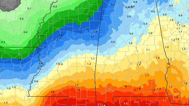
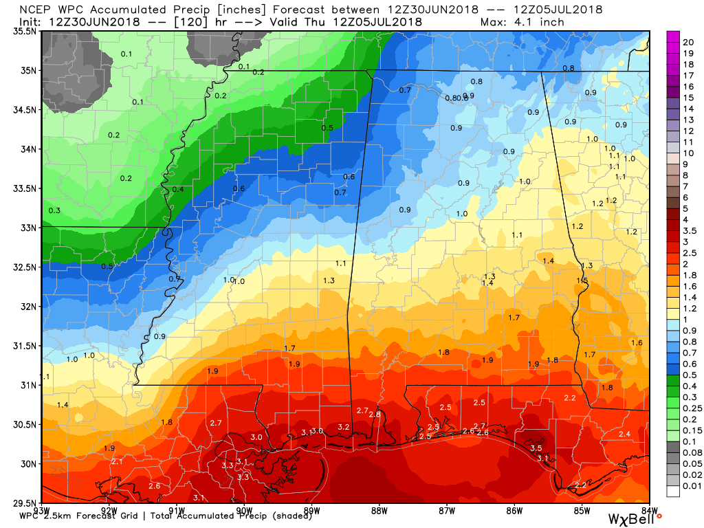
Rainfall for the first few days of July is expected to be around three-quarters to 1.25 inches in Central Alabama. Higher amounts are forecast for South Alabama and along the Gulf Coast, thanks to the weak upper low traversing the area.
LONG TERM: Looking out into voodoo country, the GFS keeps our pattern somewhat unsettled through July 11 with an upper-level pattern showing a weak troughiness over the eastern third of the country. But by July 13 the pattern reverts to a large ridge over the Mississippi River Valley and the eastern half of the country, suggesting a return to higher heat.
TROPICS: All remains quiet across the Atlantic basin, with lots of dry air and cooler-than-average water temperatures across the South Atlantic. No tropical issues are expected through next week.
BEACH FORECAST: Click here to see the AlabamaWx Beach Forecast Center page.
WEATHERBRAINS: You can listen to our weekly 90-minute netcast any time on the web, or on iTunes. This is the show all about weather featuring many familiar voices, including meteorologists at ABC 33/40.
Enjoy the day, but be sure to stay weather aware when it comes to thunderstorms so you don’t become a lightning statistic. Godspeed.
For more weather news and information from James Spann, Brian Peters and other members of the James Spann team, visit AlabamaWx.


