James Spann: A few showers, storms for Alabama today
James Spann has the Alabama forecast for the work week ahead from Alabama NewsCenter on Vimeo.
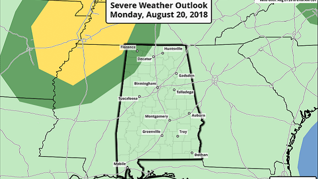
ON THE MAPS: We have a deep upper trough for late summer over the nation’s midsection this morning, driving a surface front in our direction. This setup will bring the risk of strong to severe storms to parts of the Mid-South today, with the primary threat for places like Little Rock and Memphis. The Storm Prediction Center has a marginal risk (level 1 of 5) defined for the northwest corner of Alabama.

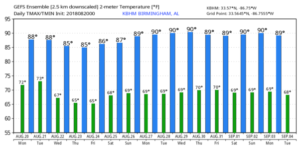
A few storms are scooting across the Tennessee Valley of far north Alabama early this morning, and a few passing showers and storms are likely statewide late today and tonight ahead of the front. Otherwise, look for a mostly cloudy day with a high in the mid 80s, which is below average for late August in Alabama.
TOMORROW THROUGH FRIDAY: The best chance of showers and thunderstorms will shift down into south Alabama by tomorrow afternoon as drier air moves into the northern counties; the sky will be partly sunny with a high between 85 and 88. Then, we go rain-free Wednesday and Thursday; these two days will be sunny with lower humidity and cooler nights. Highs will be in the 80s, lows well down in the 60s. Some of the traditionally cooler spots could see upper 50s early Thursday and Friday morning.
Some moisture will try and creep into the state from the east Friday, but for now we will mention only a slight risk of a shower. Otherwise, Friday will be partly to mostly sunny with a high in the upper 80s.
THE ALABAMA WEEKEND: We will forecast a partly sunny Saturday and Sunday with widely scattered, mostly afternoon and evening showers and thunderstorms. The chance of any one spot getting wet is only about 1 in 5, and highs will be in the upper 80s both days.
NEXT WEEK: Heat levels will creep up, with highs reaching the low 90s on most afternoons as an upper high begins to rebuild; afternoon showers and storms should remain widely scattered.
TROPICS: All is very quiet across the Atlantic basin this morning, and tropical storm formation is not expected through the week. We are getting into the peak of the hurricane season, but cooler water and dry air is mitigating any activity for now.
BEACH FORECAST: Click here to see the AlabamaWx Beach Forecast Center page.
WEATHER BRAINS: You can listen to our weekly 90-minute netcast any time on the web, or on iTunes. This is the show all about weather featuring many familiar voices, including meteorologists at ABC 33/40. We will produce this week’s show tonight at 8:30. You can watch it live here.
CONNECT: You can find me on the major social networks:
Facebook
Twitter
Google Plus
Pinterest
Snapchat: spannwx
For more weather news and information from James Spann and his team, visit AlabamaWx.


