James Spann: Multiple-day excessive rain for Alabama next week
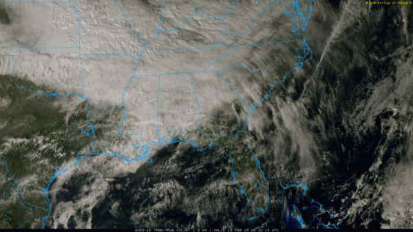
RADAR CHECK: We are just seeing a few widely scattered showers on radar this afternoon; the sky is cloudy with temperatures in the 60s. A cold front is near the Alabama/Tennessee state line; we are seeing mostly 40s over Tennessee on the north side of the front.
As that boundary moves through tonight, look for occasional showers. Rain amounts should be less than one-half inch, and there is no threat of severe storms.
THE ALABAMA WEEKEND: The front will drift down into the southern counties of the state Saturday; showers during the day should be confined to areas south of U.S. 84. For north and central Alabama, Saturday should be dry with morning clouds giving way to some afternoon sun. The high will be in the 50s over north Alabama, with 60s to the south.
The front moves northward Sunday as a warm front, and showers are possible statewide with highs in the 60s.
FOOTBALL WEATHER: The weather will be cool and dry for tomorrow’s Birmingham Iron vs. Salt Lake City Stallions game at Legion Field (1 p.m. kickoff). The sky will be generally cloudy, although some sun is possible at times. Temperatures will be in the upper 50s during the game.
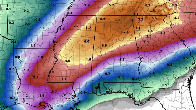
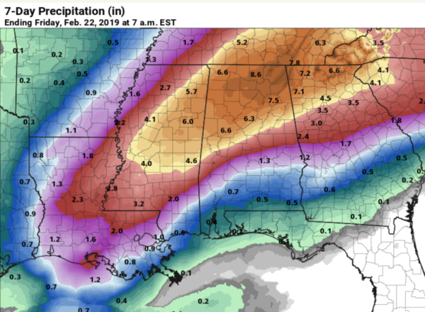
FLOODING POTENTIAL NEXT WEEK: Monday looks generally dry with just a few widely scattered showers, but we are looking at a multiple-day, excessive rain event Tuesday through Friday. The combination of a broad upper trough to the west, a stalled surface boundary and very high precipitable water values will bring heavy rain at times to the northern half of Alabama on these four days. Rain amounts of 4 to 8 inches are possible, with isolated heavier totals not out of the question. If you live in a flood-prone area, understand this is a significant threat and make preparations now. Also, the rain will bring the risk of longer-term river flooding.
A few thunderstorms are possible at some point next week, but for now the threat of severe storms looks rather low. There’s no sign of any excessively cold air for Alabama for the next seven to 10 days.
SEVERE WEATHER AWARENESS WEEK IN ALABAMA IS NEXT WEEK: This week promotes the importance of reviewing all information concerning severe weather and its associated preparedness. The primary spring severe weather season here is March, April and May. There were 46 tornadoes documented in Alabama last year. The 30-year tornado average (1989-2018) is 47. The record number of tornadoes in a year was back in 2011, when 145 tornadoes touched down. This extreme number was due to tornado outbreaks on April 15 and on April 27.
BEACH FORECAST: Click here to see the AlabamaWx Beach Forecast Center page.
WEATHER BRAINS: You can listen to our weekly 90-minute show any time on your favorite podcast app. This is the show all about weather featuring many familiar voices, including meteorologists at ABC 33/40.
CONNECT: You can find me on the major social networks:
Facebook
Twitter
Instagram
Pinterest
Snapchat: spannwx
For more weather news and information from James Spann and his team, visit AlabamaWx.


