Scott Martin: Alabama faces potential for severe storms late tonight into Sunday
TODAY: A stalled-out cold front will begin to work its way northward as a warm front during the afternoon and will help push any shower and thunderstorm activity out of Alabama and up into Tennessee by noon today. After that, we’ll have a lull in the activity as we wait for the low out to our west to move closer. While a few isolated showers or thunderstorms may be possible during the afternoon and evening, the main action will not move into western Alabama until the very late night and into the overnight hours. Highs will be in the mid-70s to the mid-80s.
SUNDAY: A line of strong to severe storms will move into western Alabama starting as early as midnight and will progress across the state overnight and into the early morning Sunday, reaching the Birmingham metropolitan area by 4 a.m. and the Gadsden/Anniston area around an hour later. The line looks to be out of here by noon Sunday, leaving some scattered showers and thunderstorms along the cold front as it moves through during the afternoon.
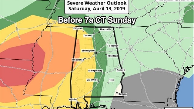
The Storm Prediction Center has the western two-thirds of the state at risk of severe storms later tonight and until 7 a.m. Sunday, then nearly all of Alabama at risk of severe storms from 7 a.m. Sunday through the afternoon.
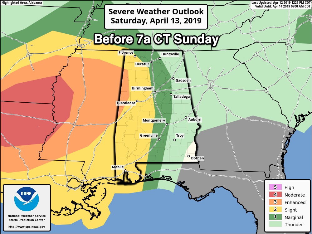
As of this morning, locations along and west of a line from Sulligent to Gordo to Eutaw are in an enhanced risk (level 3 of 5) for tonight and overnight. A slight risk (level 2 of 5) is up for locations east of that to a line from Arley to Hueytown to Selma. A marginal risk (level 1 of 5 ) stretches out to a line from Attalla to Talladega to Pike Road.
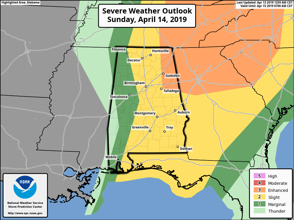
On Sunday, an enhanced risk has been defined for locations east of a line from Attalla to Talladega to Wedowee. A slight risk is up for locations east of a line from Double Springs to West Blocton to Orrville. A marginal risk is up for the rest of the state with the exception of locations west of a line from Aliceville to Demopolis.
The main window of strong to severe storms will be from midnight through 1 p.m. To break it down, that will be from midnight to 6 a.m. for the western third of the state, including Hamilton, Tuscaloosa, Demopolis, Jasper, Fayette, Double Springs and Eutaw; from 4 a.m. to 8 a.m. for locations in the central third of Alabama, including Birmingham, Oneonta, Gadsden, Clanton, Selma, Alabaster and Talladega; and from 7 a.m. to 1 p.m. for the eastern third, including Anniston, Heflin, Alexander City, Auburn, Montgomery, Troy and Eufaula.
Tornadoes and damaging winds up to and over 60 mph will be the main threat with these storms, with hail of 1 inch in diameter being a smaller threat.
Once the cold front moves through, skies will begin to clear quickly and Sunday night will be clear. Highs top out in the lower 70s to the lower 80s.
CALL TO ACTION: If you do not have a weather emergency supply kit ready to go, now is the time to make one. Have a safety plan ready if your location goes under a warning, and talk it over with family members to make sure they know what to do. Never rely on sirens for your source of receiving warnings. Enable the WEAs (Wireless Emergency Alerts) on your cell phones, or download the FEMA app from the app store. You can set up your location and receive only the warnings you want to hear. Have a NOAA WeatherRadio for the home. Download the ABC 33/40 app on your mobile device so you can watch live tornado coverage from your safe place if you go under a warning. Check on your neighbors and the elderly and make sure they know about the threat for severe storms. Be sure they have a place of safety and supplies they would need to get through.
MONDAY: On Monday, the system that brought us our severe weather threat for this weekend is well off the Atlantic coast as high pressure begins to build over the Gulf Coast of Louisiana. We’ll have plenty of sunshine with cooler temperatures, only reaching the upper 60s to the lower 70s for the afternoon highs, with morning lows starting off in the 40s.
TUESDAY: The weather will be very nice and much warmer on Tuesday as that high will be on the North Carolina coast, sending warmer air up from the south. We’ll have sunny skies with highs topping out in the mid-70s to the lower 80s, with morning lows starting off in the mid to upper 40s.
WEDNESDAY: Wednesday will start off with a mix of sun and clouds, but those clouds will increase throughout the day as our next system starts to gather strength out west. We could see a few showers over the northwestern parts of the area before midnight, but we should stay dry through the day. Highs will be in the mid-70s to the lower 80s.
THURSDAY: Another dynamic system will bring the potential for strong to severe storms on Thursday as a strong 983 mb low will be stationed over the Kansas-Missouri border at midday. At this point, the models show plenty of instability and shear in place, but we’ll have to get through tonight’s threat before we can focus on this system. Highs will be in the mid-70s to the lower 80s.
FRIDAY: The system will begin to depart Friday morning, with rain ending before noon. Skies will begin to clear soon after and highs will reach only the upper 60s to the mid-70s.
BEACH FORECAST: Click here to see the AlabamaWx Beach Forecast Center page.
For more weather news and information from James Spann, Scott Martin and other members of the James Spann team, visit AlabamaWx.


