Scott Martin: Potential for strong to severe storms in Alabama today
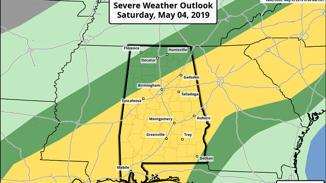
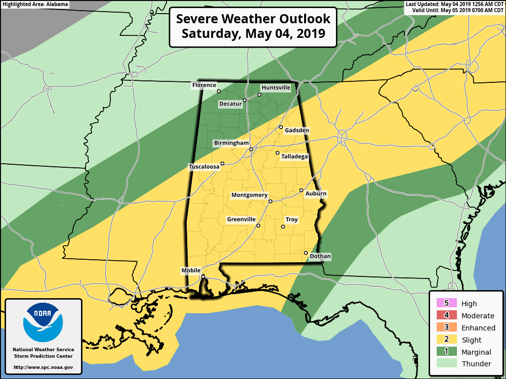
STRONG TO SEVERE STORMS POSSIBLE: The Storm Prediction Center continues a slight risk of severe storms (level 2 of 5) for all locations south of a line from Reform to Smoke Rise to just south of Fort Payne. The rest of the northern parts of the state are in a marginal risk (level 1 of 5) with the exception of the extreme northwestern corner. The main threat will be from damaging thunderstorm wind gusts up to 60 mph with a smaller threat of quarter-sized hail. The threat of tornadoes is not expected, as the winds will be unidirectional in nature.
The main window for stronger to severe storms will be from around 1 p.m. until around 10 p.m. from west to east. Timing will be from 1 p.m. to 5 p.m. in the western third of the state, 3 p.m. to 7 p.m. in the central third and 6 p.m. to 10 p.m. in the eastern third.
A surface low will be moving up from southeastern Louisiana that will bring the main concentration of rain and thunderstorms into western Alabama by mid-afternoon, but we do have the possibility of individual cells developing out ahead of those that could become strong as well.
The chance of stronger to severe storms will be a little higher along and south of the US-80 and I-85 corridors, but the potential is there for almost all of Alabama.
Much of the activity will be out of the state by midnight tonight, but a few lingering showers and storms will be possible on the backside of the low. Afternoon highs will be in the mid-70s to the lower 80s, with lows in the lower to mid-60s. Rainfall amounts will be around 1 inch or less.
SUNDAY: We’ll start off the day with a few lingering showers in eastern Alabama. Skies will be clearing throughout the late morning through the afternoon, becoming clear by late night. Highs will be in the upper 70s to the lower 80s.
MONDAY: We return to the warm conditions that we have been seeing over the past week. There will be plenty of sunshine with highs topping out in the mid to upper 80s.
TUESDAY: We’ll stay dry again throughout the day, but another low will form to the west over the Red River on the Texas/Oklahoma border and move east-northeast. Skies will be sunny to start, but clouds will begin to move in during the afternoon and evening. Highs will top out in the upper 80s to the lower 90s.
WEDNESDAY: At midday, that low will be over extreme western Kentucky and southern Illinois, which will pull moisture up from the Gulf of Mexico and across Alabama. We’ll have to watch this system as a few strong storms may be possible, but we’ll have better details as we get closer. We’ll have showers and thunderstorms possible throughout the day with highs topping out in the lower to mid-80s.
THURSDAY: Unsettled weather continues as a cold front will be just to our west and northwest, keeping showers and thunderstorms possible across the area. Chances will be higher over northern Alabama. Once again, we’ll have to watch for the potential for strong storms. Afternoon highs will be in the 80s.
FRIDAY: The front moves closer but looks to become stationary just outside Alabama, which will keep our weather unsettled not only on Friday, but throughout the weekend as well. Showers and thunderstorms will be likely, with the higher chances over the northern half of the state. Highs will be in the lower to mid-80s.
BEACH FORECAST CENTER: Get the latest weather and rip current forecasts for the beaches from Fort Morgan to Panama City on our Beach Forecast Center page. There, you can select the forecast of the region you are interested in.
For more weather news and information from James Spann, Scott Martin and other members of the James Spann team, visit AlabamaWx.


