James Spann: Rain for some in Alabama on Saturday
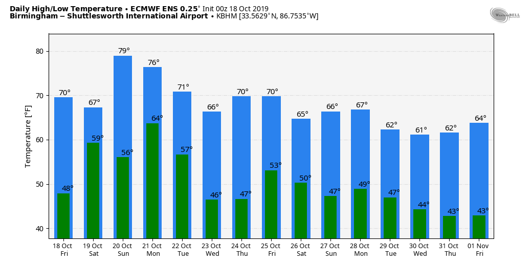
CLOUDY, COOL DAY: A deck of mid- to high-level clouds covers Alabama this afternoon, on the top side of the circulation of Tropical Storm Nestor in the Gulf of Mexico. Temperatures are only in the low to mid 60s in many areas, about 10 degrees below average for mid-October in Alabama.
To the south, rain has moved into Mobile and Baldwin counties, and that rain shield will move up into other parts of south Alabama in coming hours.
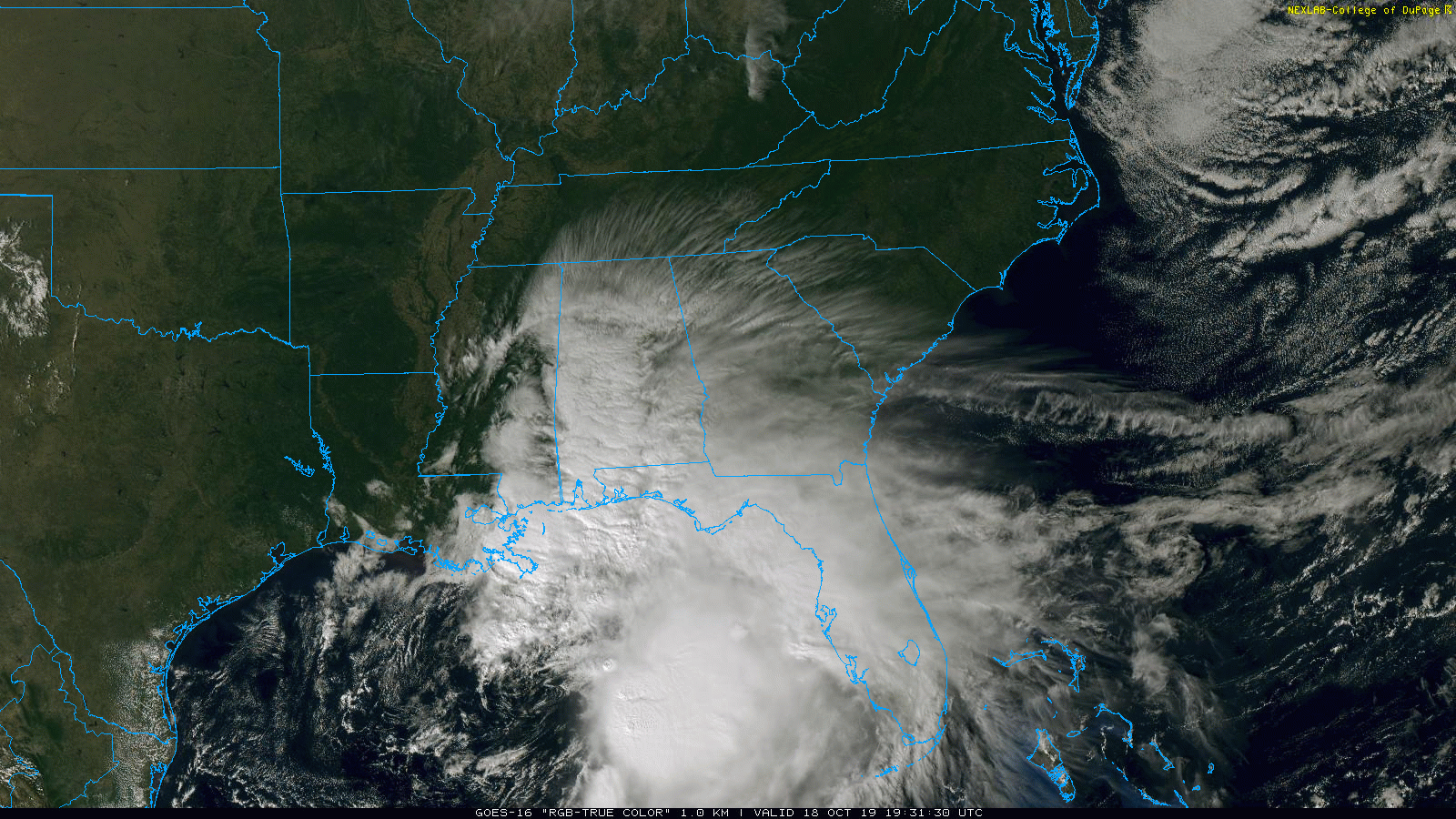
NESTOR: Tropical Storm Nestor has formed in the Gulf of Mexico with 60 mph winds. Landfall comes early Saturday over the Florida Panhandle.
A Tropical Storm Warning is in effect from the Mississippi/Alabama border to Yankeetown, Florida, and from Grand Isle, Louisiana, to the mouth of the Pearl River. A Storm Surge Warning is in effect from Indian Pass, Florida, to Clearwater Beach, Florida.
There is a danger of storm surge inundation of up to 5 feet above ground level beginning later today along the Florida Gulf Coast from Indian Pass to Clearwater Beach, where a Storm Surge Warning is in effect. Residents in these areas should follow advice given by local officials.
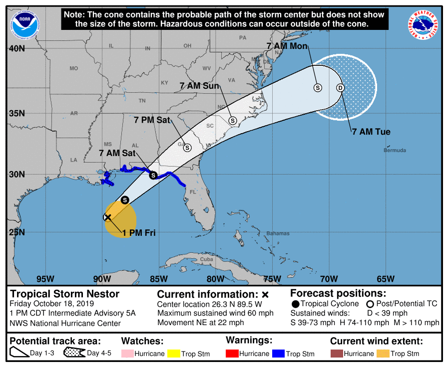
Tropical-storm-force winds are likely later today and tonight along portions of the central and eastern Gulf Coast, where tropical storm warnings are in effect. Regardless of the exact track and intensity of the system, these winds will cover a large area, especially east of the center.
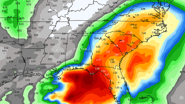
Isolated flash flooding is possible along the central and eastern Gulf Coast and the southeast United States coast through Saturday night.
ALABAMA IMPACT: The heaviest rain in Alabama will come over the southeast corner off the state, where places like Dothan could see 1-2 inches through Saturday. Winds across southeast Alabama will gust to 30-40 mph Saturday. For the rest of Alabama, look for some light rain at times Saturday with temperatures holding in the cool 60s.
Sunday will be dry and warmer; look for a partly sunny sky with a high in the mid to upper 70s.
STRONG STORMS EARLY NEXT WEEK: Monday will be mild and breezy, and a cold front will bring a band of showers and strong thunderstorms to the state Monday night. The Storm Prediction Center has much of northwest and west Alabama in a severe weather risk in its outlook for Monday and Monday night.
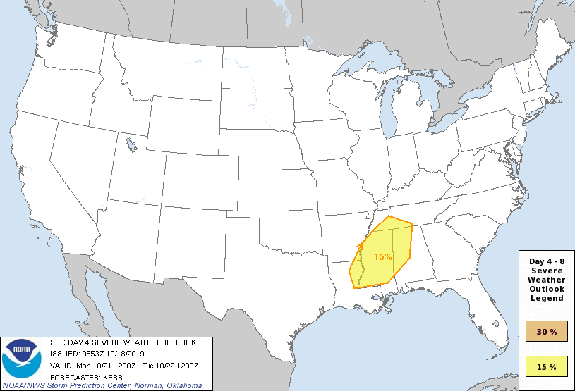
For now it looks like the main threat will come from strong, possibly damaging winds with the thunderstorms along the front. We will have a much better assessment of the situation over the weekend when the tropical system moves out of the region.
The middle of next week will be dry and pleasant; then more rain and storms will arrive by Friday with another fairly robust mid-latitude weather system.
 FOOTBALL WEATHER: For the high school games tonight, dry weather is expected over the northern half of Alabama with temperatures around 60 degrees. But rain is a good possibility for the southern quarter of Alabama as the tropical storm approaches.
Auburn travels to Fayetteville, Arkansas, to take on the Razorbacks Saturday (kickoff at 11 a.m. Central). Showers are possible during the first half of the game. The kickoff temperature will be close to 64 degrees, rising into the upper 60s by the final whistle.
Alabama will host Tennessee Saturday night at Bryant-Denny Stadium in Tuscaloosa (kickoff at 8). The weather will be dry with a clearing sky. Temperatures will be in the low to mid 60s. A little light rain is possible during the day, before the game.
UAB hosts Old Dominion Saturday afternoon at Legion Field in Birmingham (kickoff at 3). The sky will be mostly cloudy, and some light rain is possible during the game. The kickoff temperature will be near 66 degrees, falling back into the low 60s by the final whistle.
Jacksonville State hosts Southeast Missouri State Saturday (3 p.m. kickoff). The sky will be mostly cloudy; rain is possible. Temperatures will fall from near 64 at kickoff into the upper 50s by the fourth quarter.
ON THIS DATE IN 2005: Hurricane Wilma developed a tiny, well-defined eye and began intensifying rapidly, reaching Category 5 strength with a record-setting pressure of 882 millibars by Oct. 19. The rapid intensification from a tropical storm to Category 5 hurricane in 24 hours was the fastest ever recorded in the Atlantic Ocean and the second-fastest worldwide, after Super Typhoon Forrest.
BEACH FORECAST: Click here to see the AlabamaWx Beach Forecast Center page.
WEATHER BRAINS: You can listen to our weekly 90-minute show any time on your favorite podcast app. This is the show all about weather featuring many familiar voices, including the meteorologists at ABC 33/40.
CONNECT: You can find me on the major social networks:
Facebook
Twitter
Instagram
Pinterest
Snapchat: spannwx
For more weather news and information from James Spann and his team, visit AlabamaWx.


