James Spann: Beautiful day for Alabama
James Spann has the midweek forecast for Alabama from Alabama NewsCenter on Vimeo.
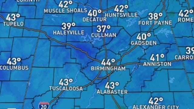
CHILLY START: For some places, this is the coldest morning so far this season across Alabama. Temperatures just before daybreak include:
- Cullman — 37
- Gadsden — 37
- Fort Payne — 37
- Pell City — 37
- Hueytown — 38
- Haleyville — 38
- Heflin — 39
- Decatur — 39
- Talladega — 39
- Selma — 39
- Anniston — 40
- Weaver — 40
- Demopolis — 40
- Jacksonville — 42
- Huntsville — 42
- Tuscaloosa — 43
- Birmingham — 44
- Jemison — 44
Some places have experienced their first frost of the season.
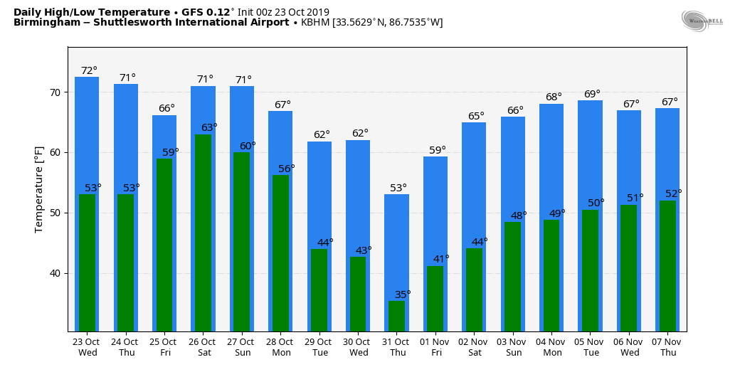
Dry, pleasant autumn weather continues through Thursday with a good supply of sunshine both days; we will see highs in the low 70s today and mid 70s Thursday. Clouds return Thursday night.
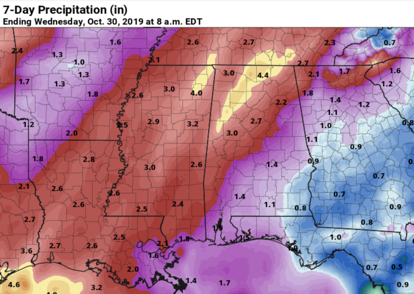
FRIDAY AND THE WEEKEND: Rain becomes widespread across Alabama Friday and Friday night as a warm front lifts northward. The rain could even be heavy at times, especially over the northern and western counties. The air should be fairly stable, so we don’t expect any severe storms, and probably little lightning. Temperatures should hold in the 60s.
The wet weather continues Saturday and Saturday night. There will be breaks in the rain, but if you are attending an outdoor event, take the rain gear. Thunderstorms could be involved as instability values will increase by afternoon, and there could even be a few strong storms involved as a cold front approaches. The rain will end from northwest to southeast late Saturday night. For now Sunday looks dry. Highs will be in the 70s over the weekend.
Rain amounts between Friday morning and Saturday night will be in the 2- to 4-inch range over much of north and central Alabama, a very beneficial rain event.
NEXT WEEK: For now much of the week looks dry, and we have potential for the coldest air so far this season to reach our state by Thursday and Friday. Some long-range guidance suggests potential for the first widespread frost of the season by Thursday morning.
TROPICS: A disturbance over Mexico will move into the Bay of Campeche by Friday; for now the National Hurricane Center gives it only a 20% chance of development. The rest of the Atlantic basin is quiet.
FOOTBALL WEATHER: For the high school games Friday night, the sky will be cloudy with rain likely; temperatures will be in the low 60s.
For Saturday’s Magic City Classic at Legion Field in Birmingham (Alabama State vs. Alabama A&M, 2:30 p.m. kickoff), the sky will be cloudy, and periods of rain are likely. A thunderstorm can’t be ruled out. The kickoff temperature will be near 70 degrees, falling into the upper 60s by the final whistle.
Auburn travels to Baton Rouge Saturday to take on LSU (kickoff at 2:30 p.m. Central). The sky will be mostly cloudy, and a few passing showers are possible during the game. Temperatures will fall from the upper 60s at kickoff into the mid 60s by the fourth quarter.
It is homecoming at the University of Alabama Saturday; the Tide will host Arkansas at Bryant-Denny Stadium (6 p.m. kickoff). It looks like rain will fall at times during the game, with a thunderstorm possible as well. Temperatures will fall from near 70 at kickoff into the upper 60s by the second half.
Jacksonville State will host Murray State Saturday (3 p.m. kickoff). Cloudy conditions are expected with some rain at times; temperatures will be in the upper 60s.
ON THIS DATE IN 2015: Hurricane Patricia became the most powerful tropical cyclone ever measured in the Western Hemisphere as its maximum sustained winds reached 200 mph and its central pressure fell to 879 millibars (25.96 inches of mercury). Patricia became the strongest Pacific hurricane on record shortly after midnight on Oct. 23. Air Force Hurricane Hunters had flown through the eye of Patricia and reported a sea-level pressure of 894 millibars as measured by a dropsonde inside the eye itself. Wind measurements suggested that the pressure measurement was not in the exact center of the eye and was probably not the absolute lowest pressure, prompting the NHC to estimate the minimum central pressure at 892 millibars. Tropical cyclone strength comparisons are typically based on minimum central pressure. At 892 millibars, Patricia shattered the Eastern Pacific basin’s previous record of 902 millibars set by Hurricane Linda in 1997. While a number of typhoons in the western North Pacific have been stronger, Patricia is now by far the strongest hurricane on record in any basin where the term “hurricane” applies to tropical cyclones – namely, the central and eastern North Pacific basins and the North Atlantic basin, which includes the North Atlantic Ocean itself plus the Gulf of Mexico and Caribbean Sea.
BEACH FORECAST: Click here to see the AlabamaWx Beach Forecast Center page.
WEATHER BRAINS: You can listen to our weekly 90-minute show any time on your favorite podcast app. This is the show all about weather featuring many familiar voices, including the meteorologists at ABC 33/40.
CONNECT: You can find me on all of the major social networks:
Facebook
Twitter
Instagram
Pinterest
Snapchat: spannwx
For more weather news and information from James Spann and his team, visit AlabamaWx.


