James Spann: Soaking rain returns to Alabama over the weekend
James Spann has the Alabama forecast for Friday through the weekend from Alabama NewsCenter on Vimeo.
ONE MORE DRY DAY: We are forecasting a partly sunny sky across Alabama today with a high in the mid 50s for the north and central parts of the state. South Alabama will see 60s this afternoon. Clouds will increase statewide tonight.
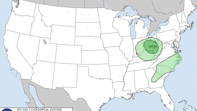
RAIN RETURNS OVER THE WEEKEND: Rain moves into south Alabama Saturday morning as a surface low moves out of the Gulf of Mexico. The rain shield will spread northward slowly during the day. Rain should begin over central Alabama Saturday afternoon, and the northern third of the state Saturday night. Rain will be widespread Saturday night into Sunday, ending from southwest to northeast Sunday afternoon. The air will be cool and stable with highs in the 50- to 55-degree range, so there will be no risk of severe storms and no thunder for most places. Heavier rain totals will be over south Alabama, with amounts of 2-4 inches likely. Totals for places like Tuscaloosa, Birmingham, Anniston and Gadsden will be 1-2 inches, with around one-half inch for the Tennessee Valley of far north Alabama.
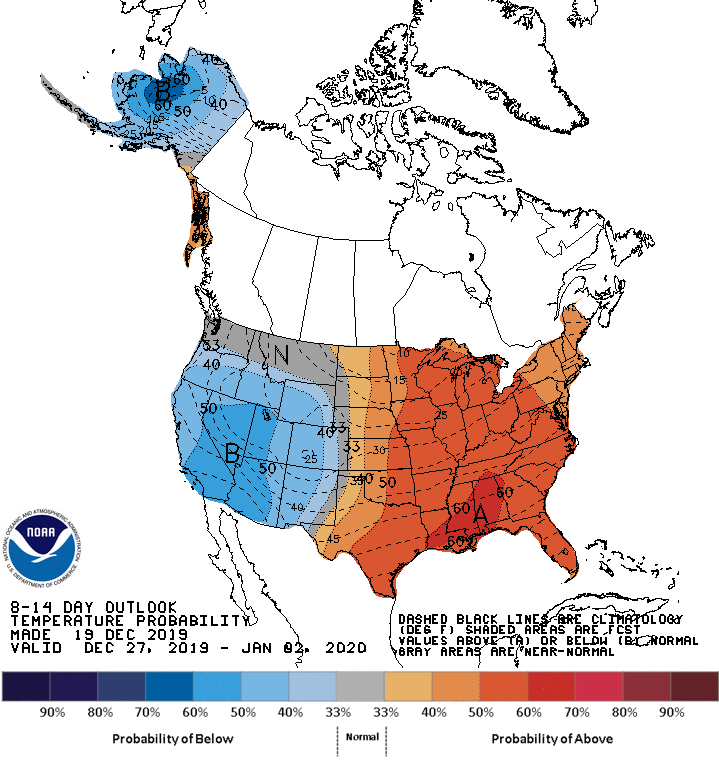
CHRISTMAS WEEK: The weather will be dry with mild afternoons and cool nights Monday through Thursday. Highs will be in the 60s, lows in the 40s. Clouds will increase Friday and a few showers are possible, but probably nothing widespread. Rain chances should increase over the following weekend, Dec. 28-29, but there is great model inconsistency for now.
TORNADO COUNT RISES: National Weather Service Huntsville sent two teams out to survey damage in both Lauderdale and Limestone counties and have returned with confirmation that two more tornadoes had touched down on Monday evening. At this point, the grand total of tornadoes that hit the state Monday is up to 12. It could rise by one more as NWS Tallahassee will be conducting a survey in Houston County on Friday. By NWS offices that cover Alabama, here are the totals per county warning area:
- NWS Huntsville — 6
- NWS Birmingham — 5
- NWS Mobile — 1
- NWS Tallahassee — 0 (survey planned for Friday)
ON THIS DATE IN 1836: A famous “sudden freeze” occurred in central Illinois. A cold front with 70 mph winds swept through around noon, dropping the temperature from 40 degrees to near zero in a matter of minutes. Many settlers froze to death. Folklore told of chickens frozen in their tracks and men frozen to saddles. Ice in streams reportedly froze to 6 inches in a few hours.
BEACH FORECAST: Click here to see the AlabamaWx Beach Forecast Center page.
WEATHER BRAINS: You can listen to our weekly 90-minute show any time on your favorite podcast app. This is the show all about weather featuring many familiar voices, including the meteorologists at ABC 33/40.
CONNECT: You can find me on the major social networks:
Facebook
Twitter
Instagram
Pinterest
Snapchat: spannwx
For more weather news and information from James Spann and his team, visit AlabamaWx.