James Spann: Potential for heavy rain, severe storms in Alabama by Friday/Saturday
JMA
James Spann has the Alabama forecast and a look at the weekend’s severe weather risk from Alabama NewsCenter on Vimeo.
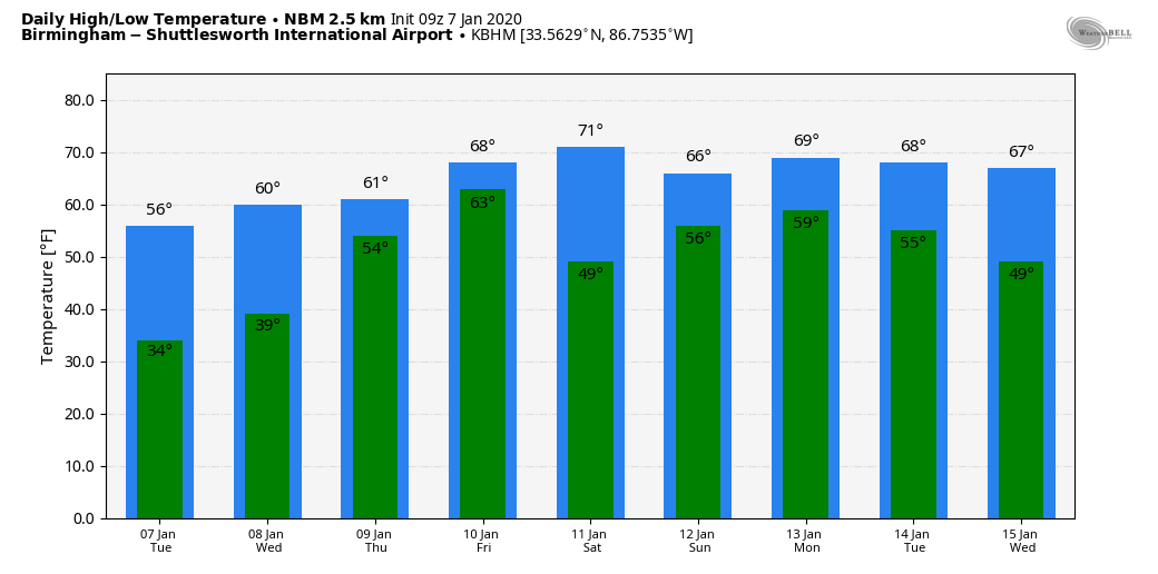
SUNNY, COOL DAY AHEAD: An upper trough brought some light rain to the northern half of Alabama overnight. That rain is now in Georgia, and a new surge of dry air is pushing into the state. Today will be sunny and a bit cooler; the high will be in the mid to upper 50s over north Alabama, with low 60s for the southern counties. Tonight will be clear and cold; the low early Wednesday will be in the 28- to 34-degree range.
Dry weather continues Wednesday with a good supply of sunshine; the high will be in the low 60s. Mid 60s are likely Thursday with a mix of sun and clouds. Clouds thicken Thursday night.
HEAVY RAIN/SEVERE THUNDERSTORM THREAT: We will have the dual threat of heavy rain and severe thunderstorms across Alabama Friday and Saturday. Rain amounts between 3 and 6 inches are likely over the northern third of Alabama, with totals around 2 inches likely for the southern part of the state. The ground is saturated and flooding is a very real possibility.
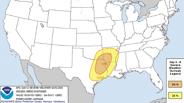
The severe weather threat begins Friday west of Alabama, through parts of east Texas, east Oklahoma, Arkansas and Louisiana; the Storm Prediction Center has a severe weather risk defined for this area on its convective outlook for Friday.
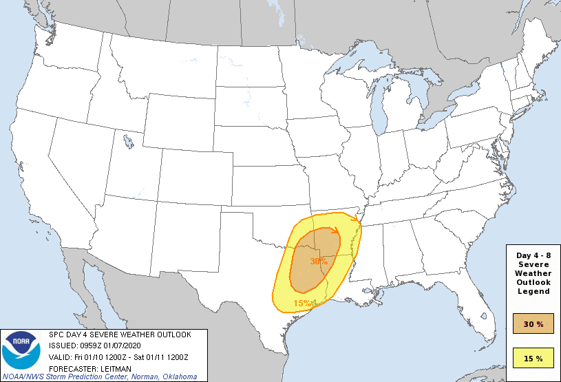
On Saturday, the risk shifts into the Deep South, including all of Alabama and Mississippi. The SPC has higher severe weather possibilities defined for west and south Alabama, but the entire state will have some risk of severe storms.
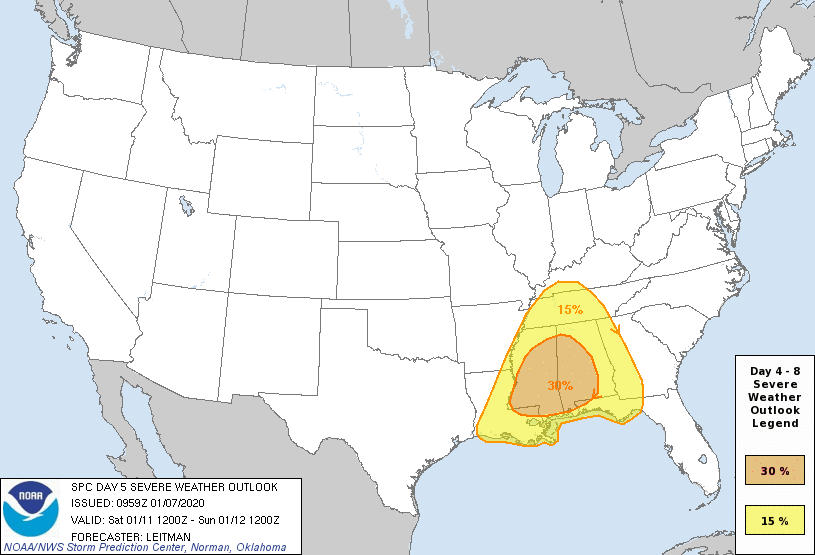
The larger, synoptic scale favors thunderstorms across Alabama Saturday that will be strong to severe; for now it looks like all modes of severe weather will be possible, including hail, damaging winds and tornadoes. This has potential to be a significant severe weather event for our state, but it is important to note that we still don’t know the smaller, mesoscale features and how they will line up. We will have a good look at this once we get within 60 hours, when the convection allowing models will be in range. It is also too early to forecast the specific timing of the higher severe weather threat.
Everyone will need to be weather aware Saturday; be sure you have a way of hearing warnings if they are needed, and have a plan in case you go in a tornado warning polygon.
Sunday will be dry following the storms with a good supply of sunshine. Temperatures will be spring-like; we reach the 70s Friday and Saturday, and even on Sunday highs will be well up in the 60s.
NEXT WEEK: A surface front will move northward across the state Monday as a warm front with rain returning; then look for another round of rain around Thursday.
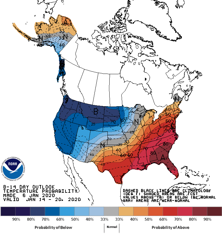
NO SIGN OF ARCTIC AIR FOR ALABAMA FOR A FEW WEEKS: The pattern will continue to favor below-average temperatures for the western and northern states, while the eastern U.S. will be fairly mild through mid-January. But remember, cold weather fans, winter is just getting started and the pattern will flip at some point.
ON THIS DATE IN 1989: An F4 tornado leveled a good portion of the town of Allendale, Illinois, and injured 55 of its residents. The tornado directly hit Allendale’s school, destroying the grade school portion built in the 1960s. The high school portion, built in the late 1920s, withstood the storm with minimal damage.
BEACH FORECAST: Click here to see the AlabamaWx Beach Forecast Center page.
WEATHER BRAINS: You can listen to our weekly 90-minute show any time on your favorite podcast app. This is the show all about weather featuring many familiar voices, including the meteorologists at ABC 33/40.
CONNECT: You can find me on the major social networks:
Facebook
Twitter
Instagram
Pinterest
Snapchat: spannwx
For more weather news and information from James Spann and his team, visit AlabamaWx.


