James Spann: Nice warm-up for Alabama today, storms Saturday
James Spann has the Alabama forecast for midweek from Alabama NewsCenter on Vimeo.
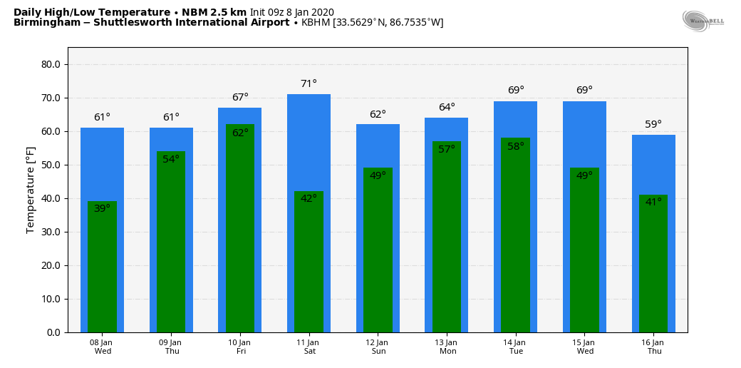
BEAUTIFUL DAY AHEAD: Temperatures were below freezing over much of Alabama early this morning; places like Gadsden, Cullman and Fort Payne were in the mid 20s just before sunrise. But look for a nice warm-up today with a high in the low 60s. The air remains very dry, and the sky will be sunny. We expect mid 60s Thursday with a mix of sun and clouds.
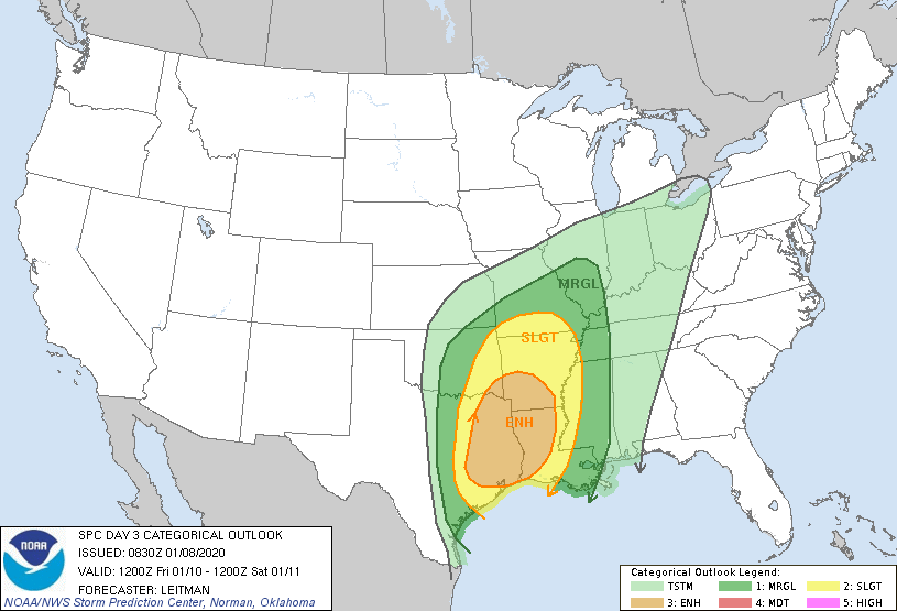
FRIDAY: Rain returns to Alabama Friday and Friday night as very moist air moves up from the Gulf of Mexico. The day will be unseasonably mild, with highs between 70 and 75 degrees. A few thunderstorms could be involved, but the severe weather threat will be west of our state. There is an enhanced risk (level 3 out of 5) of severe thunderstorms Friday over parts of east Texas, Arkansas, Louisiana and the southeast corner of Oklahoma.
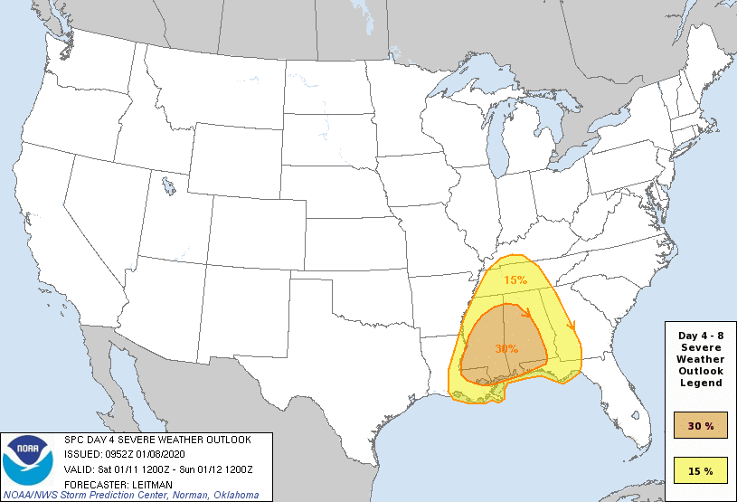
SEVERE WEATHER THREAT FOR ALABAMA SATURDAY: A dynamic weather system with very strong wind fields will interact with an unstable air mass to bring the threat of severe thunderstorms and heavy rain to our state Saturday. The Storm Prediction Center has all of the state in a severe weather risk in its outlook for Saturday, which features probabilistic areas. A 30% area covers much of the state, which is the equivalent of an enhanced risk.
Based on the forecast large, synoptic-scale state of the atmosphere, this could be a fairly signifiant severe weather threat for our state. But we won’t know how the small, mesoscale features line up until we get closer to the weekend. This system will feature a screaming low-level jet; winds 5,000 feet off the ground should be in the 50- to 80-knot range, yielding very strong storm relative helicity values (veering of the wind with altitude in relation to storm motion).
Thunderstorms on Saturday will be capable of producing hail, damaging winds and tornadoes. In terms of timing, it looks like a daytime event. Strong to severe storms could enter west Alabama as early as 7 to 9 a.m., and the threat should be over by Saturday evening. We will be more specific about the timing on Thursday.
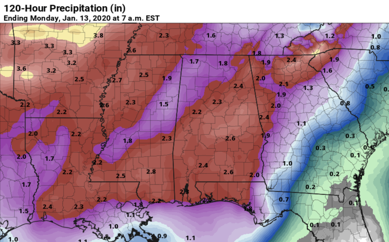
Heavy rain is another concern; rain amounts Friday and Saturday will be in the 2- to 3-inch range; the ground is relatively saturated and flooding is very possible.
CALL TO ACTION: Everyone will need a good, reliable way of getting severe weather warnings Saturday if they are needed. Be sure wireless emergency alerts are enabled on your phone, and download the free ABC 33/40 weather app as well. Have a NOAA Weather Radio in your home and business. Never rely on an outdoor siren.
Identify the safe place in your home. In a site-built home, it is a small room on the lowest floor, near the center of the home and away from windows. Be sure everybody in the family knows where that safe place is, and in that room you need helmets for everyone in your family. We also recommend having a portable air horn for everyone, as well as hard-soled shoes. If you live in a mobile home, you cannot stay there if you are in a tornado warning polygon. Know the location of the nearest shelter or site-built structure that is available.
Is a tornado threat in January unusual? Not really. Alabama has experienced 139 tornadoes during the month of January since 1950. Tornadoes can happen during any month in our state, but the most active period is between November and May.
Sunday will be dry with a mix of sun and clouds; the high will be in the low 60s.
NEXT WEEK: A northward-moving warm front will bring rain back into Alabama Monday, and some chance of rain will continue into Tuesday and Wednesday. Seven-day rain totals for the state are expected to be in the 4- to 6-inch range. There’s still no sign of any Arctic air; temperatures should remain above average through the week.
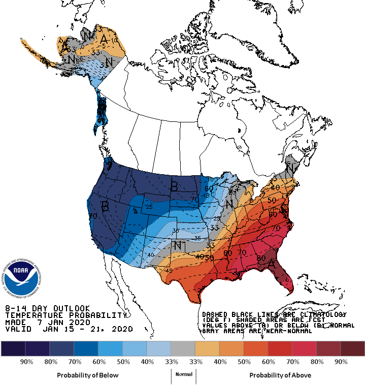
The Climate Prediction Center outlook for Jan. 15-21 continues to suggest very cold air for the northern and western U.S. but mild conditions across the southern states.
ON THIS DATE IN 1973: As much as 4 inches of ice coated most of northern Georgia, leaving 300,000 people without electricity for as much as a week. Damage was estimated at $25 million. Much of Alabama narrowly escaped this event with mainly a heavy, cold rain, although some icing was reported from Fayette to Scottsboro and along the eastern side of the state to near Talladega. Significant icing was reported around Muscle Shoals.
BEACH FORECAST: Click here to see the AlabamaWx Beach Forecast Center page.
WEATHER BRAINS: You can listen to our weekly 90-minute show any time on your favorite podcast app. This is the show all about weather featuring many familiar voices, including the meteorologists at ABC 33/40.
CONNECT: You can find me on the major social networks:
Facebook
Twitter
Instagram
Pinterest
Snapchat: spannwx
For more weather news and information from James Spann and his team, visit AlabamaWx.


