James Spann: Alabama still dry today; storms likely Saturday
James Spann has the Alabama forecast for Thursday and the latest on the weekend storms from Alabama NewsCenter on Vimeo.
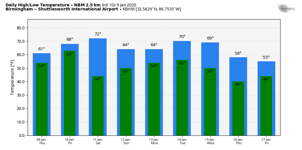
ONE MORE DRY DAY: Look for a high in the mid 60s across much of Alabama today with a mix of sun and clouds. Tonight, the sky becomes mostly cloudy as moist air surges northward from the Gulf of Mexico. Friday will be a mostly cloudy, very mild day; the high will be close to 70 degrees, about 15 degrees above average for mid-January in Alabama. We will mention a chance of showers by afternoon, but rain becomes more likely Friday night.
To the west, severe thunderstorms are likely Friday through parts of east Texas, southeast Oklahoma and much of Louisiana and Arkansas.
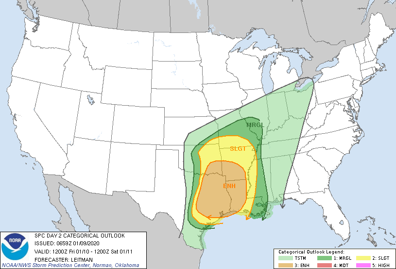
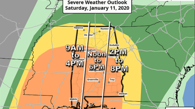
SATURDAY SEVERE WEATHER THREAT: A dynamic weather system with strong wind fields will bring a good chance of severe thunderstorms to Alabama Saturday. The low-level jet (about 5,000 feet off the ground) is forecast to be in the 50- to 80-knot range, making for very high storm relative helicity values (veering of the wind with attitude in relation to storm motion). The Storm Prediction Center has defined an enhanced risk (level 3 out of 5) of severe thunderstorms for the southern two-thirds of the state, south of a line from Vernon to Birmingham to Talladega to Lafayette, with a slight risk (level 2 of 5) for the rest of the state up to the Tennessee state line.
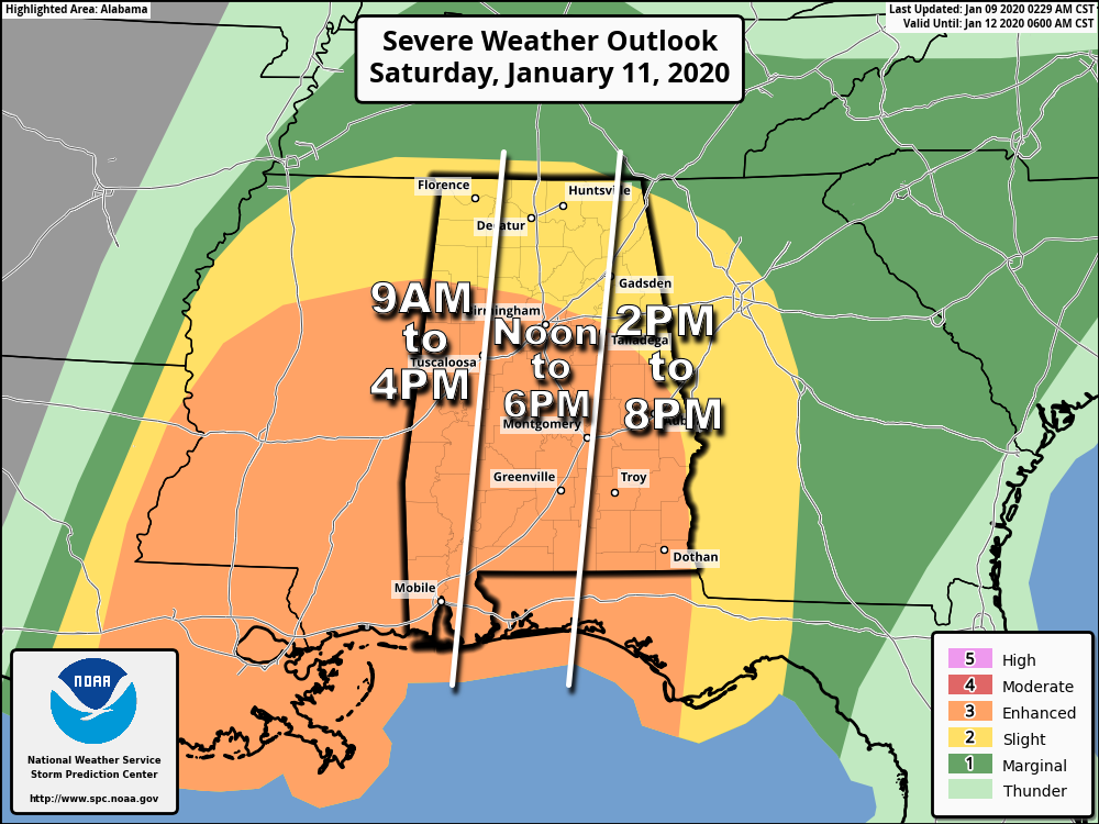
TIMING: The main window for severe storms over the western side of the state will come from 9 a.m. until 4 p.m.; for the central counties the window is from noon to 6 p.m., and for east Alabama 2 p.m. until 8 p.m. This will be a generally daytime event.
THREATS: A line of storms will sweep through the state Saturday with potential for damaging winds and a few embedded tornadoes. Any discrete cells that form east of the line will be capable of producing a few tornadoes as well. Based on the forecast parameters, a few strong tornadoes (EF2 or higher) can’t be ruled out. Also, some hail is possible with the heavier thunderstorms. Away from thunderstorms, pressure gradient winds will be fairly robust during the day; expect a south wind averaging 15-25 mph with higher gusts.
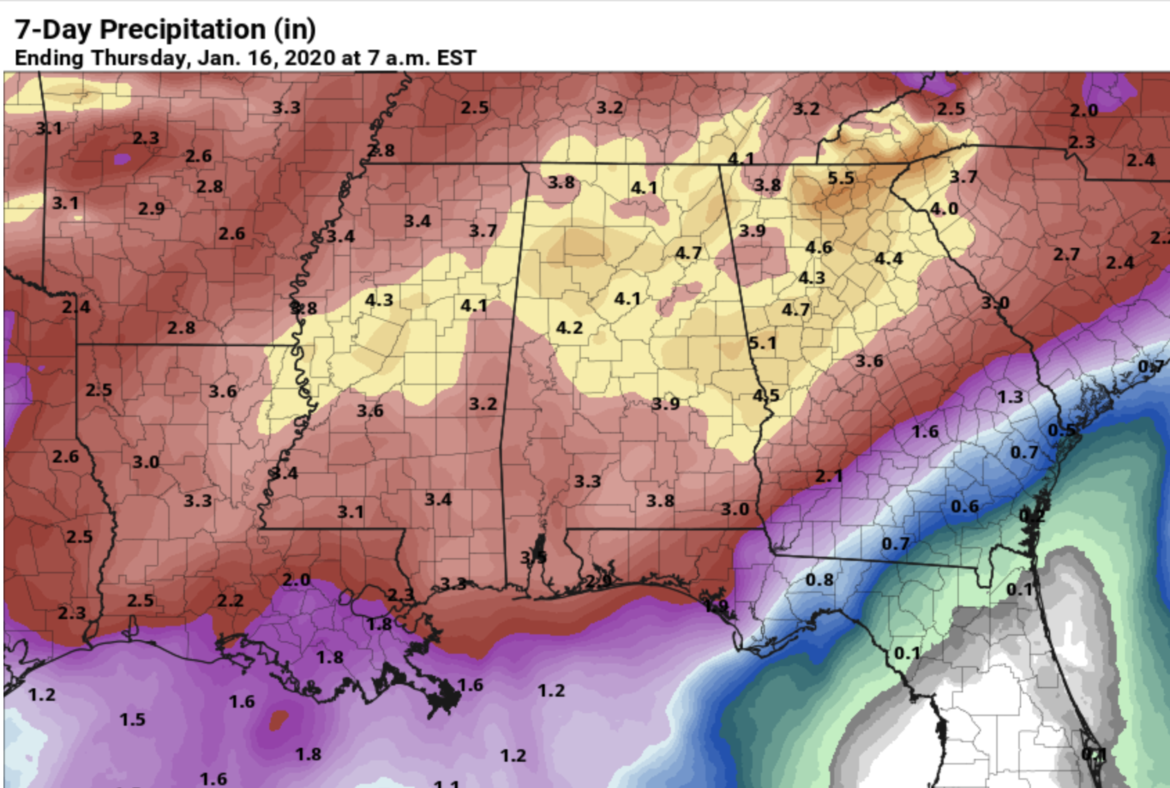
RAIN: Rain amounts Friday night and Saturday should be around 2 inches for much of Alabama; some flooding issues are possible. Seven-day rain totals through Thursday of next week are in the 4- to 5-inch range over north Alabama, with 3-4 inches for the southern counties as more rain is likely next week.
CALL TO ACTION: Everyone will need a good, reliable way of getting severe weather warnings Saturday if they are needed. Be sure wireless emergency alerts are enabled on your phone, and download the free ABC 33/40 weather app as well. Have a NOAA Weather Radio in your home and business. Never rely on an outdoor siren.
Identify the safe place in your home. In a site-built home, it is a small room on the lowest floor, near the center of the home and away from windows. Be sure everybody in the family knows where that safe place is, and in that room you need helmets for everyone in your family. We also recommend having a portable air horn for everyone, as well as hard-soled shoes. If you live in a mobile home, you cannot stay there if you are in a tornado warning polygon. Know the location of the nearest shelter or site-built structure that is available.
Is a tornado threat in January unusual? Not really. Alabama has experienced 139 tornadoes during the month of January since 1950. Tornadoes can happen during any month in our state, but the most active period is between November and May.
Do I need to cancel my event Saturday? I’m getting many questions about both indoor and outdoor events. All of them involve a different set of circumstances, and there is no way we can make that decision.
Sunday will be dry with a mix of sun and clouds; the high will be in the low 60s.
NEXT WEEK: Moist air returns, and we forecast periods of rain Monday through at least Wednesday. No severe storms are expected and the weather stays mild, with highs in the 60s.
ON THIS DATE IN 2006: With cold air sweeping in from the Himalayas, New Delhi reported frost for the first time in 70 years with a low temperature of 32.3 degrees. The cold prompted officials to order all schools to close for three days.
BEACH FORECAST: Click here to see the AlabamaWx Beach Forecast Center page.
WEATHER BRAINS: You can listen to our weekly 90-minute show any time on your favorite podcast app. This is the show all about weather featuring many familiar voices, including the meteorologists at ABC 33/40.
CONNECT: You can find me on the major social networks:
Facebook
Twitter
Instagram
Pinterest
Snapchat: spannwx
For more weather news and information from James Spann and his team, visit AlabamaWx.