James Spann: Wet weather continues across Alabama
James Spann has the forecast for the soggy state of Alabama from Alabama NewsCenter on Vimeo.
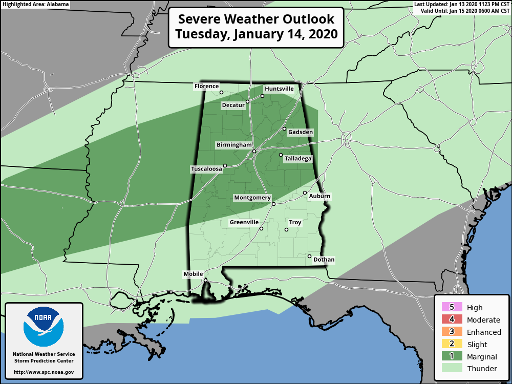
WET AGAIN: A large mass of rain is over north Alabama this morning, moving slowly southward. Because of the saturated soil, National Weather Service offices have issued a flood watch for about the northern half of Alabama through tonight; some localized flooding is possible as the rain falls today. Amounts of around 1 inch are possible. Also, the Storm Prediction Center maintains a marginal risk (level 1 out of 5) of severe storms for north and central Alabama. A few storms could produce small hail and gusty winds, but the overall threat is low.
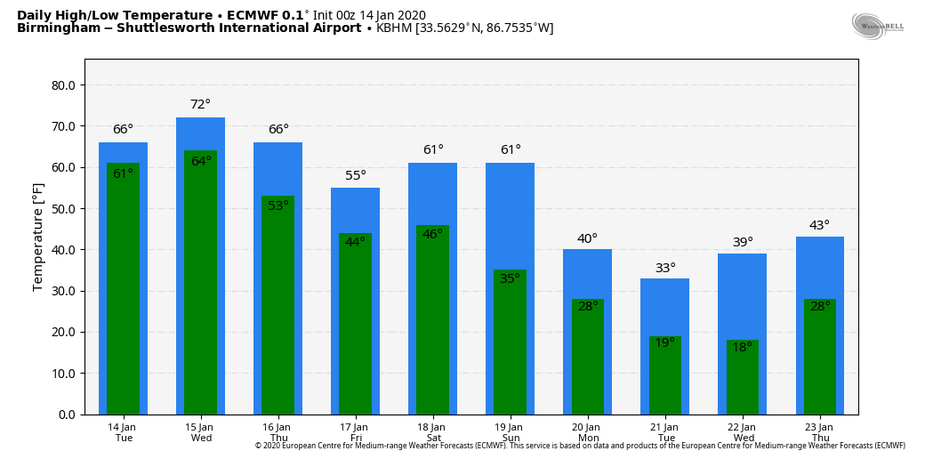
The temperatures will stay very mild today, with a high in the 67- to 71-degree range. Wednesday will feature a high in the low 70s; the sky will remain mostly cloudy with a chance of showers and possibly a thunderstorm.
THURSDAY/FRIDAY: Cooler air will slip into much of Alabama on these two days; highs drop into the upper 50s over north Alabama. Thursday will be generally dry with a mix of sun and clouds, but showers are possible Friday as moisture begins to return from the south.
THE ALABAMA WEEKEND: A cold front will pass through Saturday with a chance of showers and thunderstorms. We’re not expecting any severe storms this time as instability will be very limited and dynamic forcing not especially strong (nothing like last Saturday). Sunday will be dry but sharply colder. North Alabama could very well hold in the 40s all day, with 50s for the southern counties of the state along with a partly sunny sky.
NEXT WEEK: The weather will be considerably colder thanks to a pattern change. Monday and Tuesday will be sunny and cold with highs only in the 30s and 40s and lows in the 20s. Some of the normally colder spots over north Alabama could easily drop into the teens. For now most of the week looks dry; there could be a few showers toward the end of the week.
ON THIS DATE IN 1972: In Loma, Montana, the temperature soared from 54 degrees below zero to 49 degrees above zero on Jan. 14-15, 1972. The 103-degree change is the greatest ever recorded in the world for a 24-hour period.
ON THIS DATE IN 1982: One of the greatest ice storms in state history continued to keep Alabama shut down. As many as 750,000 Alabamians lost electrical service; some were in the dark for more than a week. Twenty Alabamians were dead and another 300 injured; damage totaled $78 million.
BEACH FORECAST: Click here to see the AlabamaWx Beach Forecast Center page.
WEATHER BRAINS: You can listen to our weekly 90-minute show any time on your favorite podcast app. This is the show all about weather featuring many familiar voices, including the meteorologists at ABC 33/40.
CONNECT: You can find me on the major social networks:
Facebook
Twitter
Instagram
Pinterest
Snapchat: spannwx
For more weather news and information from James Spann and his team, visit AlabamaWx.


