James Spann: Cold, dry weather for Alabama through Wednesday
James Spann has the Alabama forecast for MLK Day from Alabama NewsCenter on Vimeo.
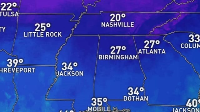
SUB-FREEZING START: Here are some temperatures around Alabama just before daybreak:
- Black Creek — 20
- Cullman — 21
- Haleyville — 21
- Heflin — 22
- Fort Payne — 22
- Decatur — 23
- Albertville — 23
- Huntsville — 23
- Weaver — 24
- Muscle Shoals — 24
- Birmingham — 26
- Anniston — 26
- Hueytown — 26
- Jemison — 26
- Bessemer — 27
- Pell City — 27
- Tuscaloosa — 29
- Prattville — 30
- Montgomery — 32
- Mobile — 34
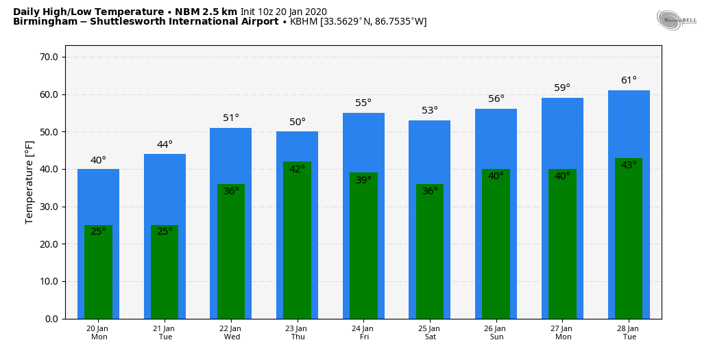
Today will be sunny but cold; areas north of Birmingham hold in the 30s all day; Central Alabama will see low to mid 40s, with low 50s over the far southern counties of of the state. Tonight will feature a freeze statewide; lows over north and central Alabama will be mostly in the 20- to 25-degree range, with a few upper teens for colder spots.
A SNOW FLAKE OR TWO? A disturbance aloft will bring some scattered mid-level clouds to Alabama tonight, and it might squeeze out a few flurries over the northern third of the state, but the air will be extremely dry and odds of those flurries reaching the surface aren’t especially high.
REST OF THE WEEK: Tuesday will be sunny and cold, with a high in the 40s. After another freeze early Wednesday with lows in the 20s, we warm into the low 50s Wednesday afternoon with a partly to mostly sunny sky.
Clouds return to the state Thursday ahead of the next weather system to the west, and we will introduce the chance of some light rain Thursday afternoon. Rain is likely Thursday night into part of the day Friday; for now it looks like the window for the most widespread rain will come from about noon Thursday to 3 p.m. Friday. Rain amounts will be around one-half to 1 inch. There is no risk of severe storms and probably no thunder with a cool, stable air mass in place. The high will be in the upper 40s Thursday, followed by mid 50s Friday.
THE ALABAMA WEEKEND: For now we are expecting a dry weekend with a partly sunny sky Saturday and Sunday. Temperatures will be pretty close to seasonal averages; the high will be in the low 50s Saturday, followed by mid 50s Sunday. A light freeze is likely early Sunday morning.
NEXT WEEK: Monday looks dry; global models suggest the next chance of rain will come around Wednesday or Thursday, Jan. 29-30. There is no sign of any significant snow or ice, or severe weather issues for Alabama for the next seven to 10 days.
ON THIS DATE IN 1937: This was the wettest Inaugural Day of record with 1.77 inches of rain in 24 hours. Temperatures were only in the 30s as Franklin D. Roosevelt was sworn in for his second term.
BEACH FORECAST: Click here to see the AlabamaWx Beach Forecast Center page.
WEATHER BRAINS: You can listen to our weekly 90-minute show any time on your favorite podcast app. This is the show all about weather featuring many familiar voices, including the meteorologists at ABC 33/40.
CONNECT: You can find me on the major social networks:
Facebook
Twitter
Instagram
Pinterest
Snapchat: spannwx
For more weather news and information from James Spann and his team, visit AlabamaWx.


