James Spann: Breezy, colder day for Alabama
James Spann has a chilly midweek forecast for Alabama from Alabama NewsCenter on Vimeo.
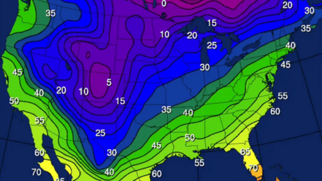
COLD FRONT PASSING THROUGH: Today will be a cloudy, breezy, colder day for Alabama thanks to a passing cold front. A few rain showers are likely over the northern counties, but rain amounts will be rather light and spotty — less than one-quarter inch for most locations. Temperatures will hold in the 40s over the northern third of the state, with 50s and 60s for south Alabama.
As colder air continues to funnel into the state tonight, a few scattered light snow flurries are possible over the northern third of Alabama, but moisture will be limited, precipitation will be very light and there will be no impact. The sky will clear after midnight, and by daybreak we expect temperatures in the 27- to 32-degree range.
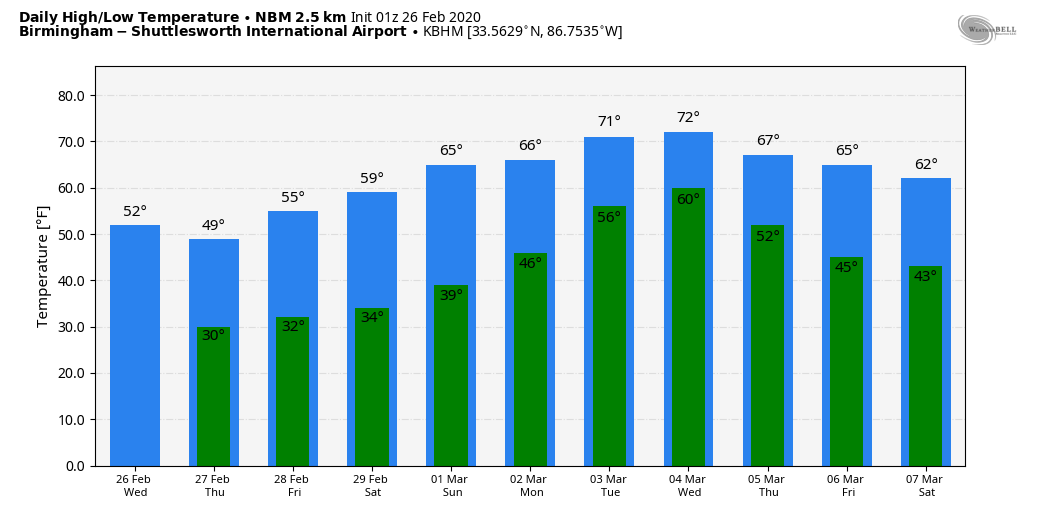
THURSDAY/FRIDAY: Look for sunshine in full force Thursday with a high close to 50 degrees. On Friday, after a low near freezing, the high will be in the mid to upper 50s. A disturbance riding down the back side of the upper trough over the East Coast could squeeze out a few light showers over north Alabama Friday afternoon and evening, and a few flurries are possible over the northeast corner of the state Friday night. Again, moisture will be very limited and precipitation will be light.
THE ALABAMA WEEKEND: The weekend will be dry with a warming trend. We are forecasting a sunny sky Saturday and Sunday; the high will be in the upper 50s Saturday, followed by mid 60s Sunday. Morning lows will be in the 30s.
NEXT WEEK: For the first week of meteorological spring, Monday and Tuesday will be mostly cloudy and very mild with some risk of showers both days. The high will be in the 68- to 72-degree range Monday, followed by low to mid 70s Tuesday. A rather robust weather system will bring rain and storms to the state Tuesday night and possibly into Wednesday. We will need to monitor this one for severe thunderstorm potential as the event gets closer. Drier air returns for the end of the week.
ON THIS DATE IN 1972: The Buffalo Creek disaster occurred in the Buffalo Creek Hollow of Logan County in West Virginia. A coal slag dam on the Middle Fork of Buffalo Creek burst, sending a 50-foot wall of water down a narrow valley, killing 125 people and causing $51 million damage. Three days of rain atop a 6-inch snow cover caused the dam to break.
ON THIS DATE IN 2008: A long-lived windstorm produced by severe thunderstorms, known as a derecho, caused a widespread swath of damage across central Alabama during the early morning. Although there were some sporadic reports of light tree damage and small hail west of Interstate 65, a more intense and widespread swath of damage started in southern Jefferson and northern Shelby counties between 3:30 and 4 a.m. From there, the damage swath moved eastward, roughly parallel to Interstate 20, reaching the Georgia border by 5 a.m. Thunderstorm wind gusts estimated at 60 to 70 mph were widespread in this damage swath, with occasional hurricane-force peak wind gusts, estimated at just over 100 mph in some areas. In addition to widespread severe thunderstorm wind damage, three EF-1 tornadoes touched down across central Alabama.
BEACH FORECAST: Click here to see the AlabamaWx Beach Forecast Center page.
WEATHER BRAINS: You can listen to our weekly 90-minute show any time on your favorite podcast app. This is the show all about weather featuring many familiar voices, including the meteorologists at ABC 33/40.
CONNECT: You can find me on the major social networks:
Facebook
Twitter
Instagram
Pinterest
Snapchat: spannwx
For more weather news and information from James Spann and his team, visit AlabamaWx.com.