James Spann: Spotty showers for Alabama over the next few days
James Spann forecasts occasional light rain for the Alabama work week from Alabama NewsCenter on Vimeo.
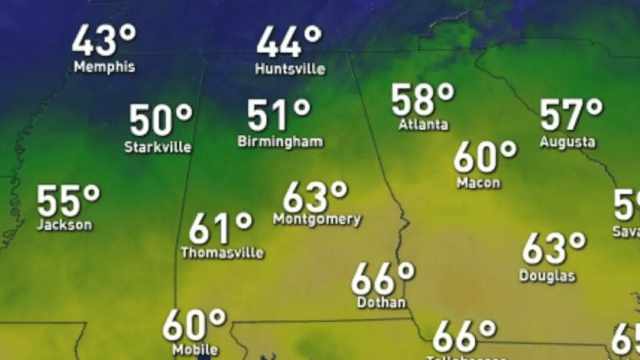
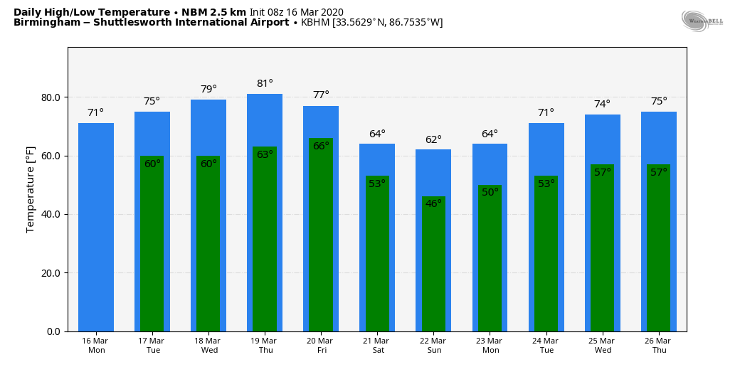
ON THE MAPS: A stalled front is over south Alabama this morning, and again we have a big temperature range across the state. At 5 a.m., Haleyville reported 43, while Dothan was at 65 on the south side of the boundary. The front will slowly drift northward today; the sky will be mostly cloudy and we will have a few scattered showers around later today and tonight — nothing widespread, nothing heavy. The high will be in the 60s over the northern half of the state, with mostly 70s for south Alabama. A few spots there could touch 80.
MIDWEEK: The weather will trend warmer. The high will be in the 68- to 73-degree range Tuesday, followed by upper 70s Wednesday and low 80s Thursday. The sky will be occasionally cloudy Tuesday and Wednesday with a few scattered showers and possibly a thunderstorm, but again the rain won’t be very widespread or heavy. Thursday looks mostly dry with a mix of sun and clouds.
FRIDAY: A cold front will push into the state, setting up a good chance of rain and possibly a few thunderstorms by Friday afternoon into Friday night. Rain amounts should be around one-half inch, and we are not expecting any severe thunderstorms. The high Friday will be in the mid 70s.
THE ALABAMA WEEKEND: The front will drift into south Alabama and stall, much like the front we have there this morning. The day will be mostly cloudy and cooler over the northern half of the state with some patchy, light rain possible; highs will be in the low to mid 60s. Sunday looks generally dry with only isolated showers; the sun peeks out at times with a high in the mid 60s. South Alabama will enjoy highs in the 70s this weekend.
NEXT WEEK: The overall pattern won’t change much, with an upper trough over the western U.S. and a ridge over the eastern states. There will be some risk of showers on most days, but again we see no signals of any really excessive rain or severe thunderstorms. Keep in mind March can feature some very volatile weather, so we are quite blessed that the pattern is fairly benign for the next seven to 10 days.
ON THIS DATE IN 1942: A total of 26 significant tornadoes, including five violent ones and 18 killers, would cause 148 fatalities from Illinois and Indiana through Kentucky and Tennessee, into Mississippi and Alabama. The Delta towns of Itta Bena and Greenwood were hit around 3 p.m. by a family of twisters that killed 63 people. Five automobiles were hurled into the Tallahatchie River near Greenwood, killing six. Two school buses were hit. The hospital at Grenada was missed by just 20 yards, even as doctors and nurses worked on patients from the first big tornado.
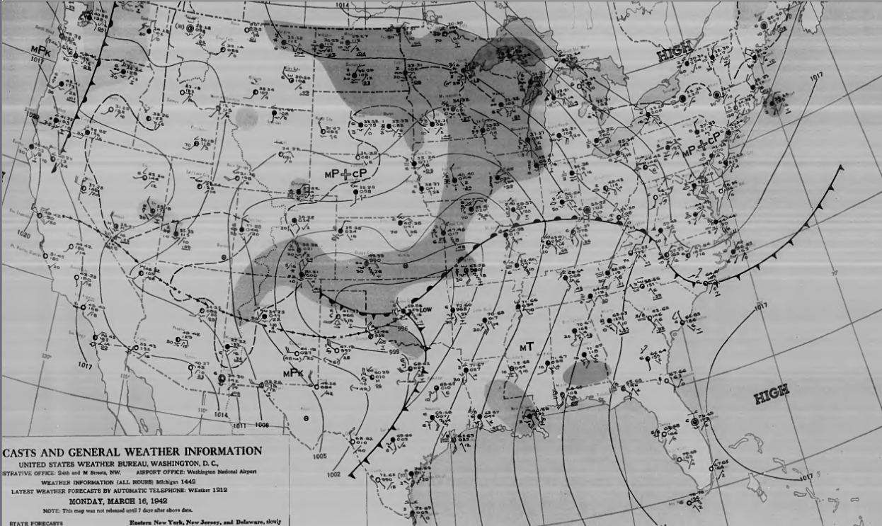
Just after 5 p.m., a powerful tornado struck the northern part of Baldwyn, Mississippi, north of Tupelo. The F4 tornado killed five people. Even as rescuers were digging through the rubble of more than 50 destroyed homes, a second tornado roared into the town a scant one-half hour later. No one died in the second tornado, although it destroyed 25% of the business district. The twin tornadoes that struck Baldwyn were the subject of tornado legend for many years.
In Alabama, a tornado killed a couple at Waterloo in Lauderdale County around 6 p.m. Their bodies were blown more than 200 yards.
BEACH FORECAST: Click here to see the AlabamaWx Beach Forecast Center page.
WEATHER BRAINS: You can listen to our weekly 90-minute show any time on your favorite podcast app. This is the show all about weather featuring many familiar voices, including the meteorologists at ABC 33/40.
CONNECT: You can find me on all of the major social networks:
Facebook
Twitter
Instagram
Pinterest
Snapchat: spannwx
For more weather news and information from James Spann and his team, visit AlabamaWx.


