Scott Martin: Strong storms possible in parts of Alabama late Saturday

POTENTIAL FOR STRONG/SEVERE STORMS LATE SATURDAY
A cold front will be progressing toward Central Alabama and will actually enter into the northwest corner of the state during the late-night and into the overnight hours. There will be a decent amount of instability that will be sufficient for rain and thunderstorms along and ahead of the front. The good news is that the instability will be dropping with time as we lose the heating of the day, so the storms will be weakening as they enter the state. The bad news is that there will be enough left over that a few strong to severe storms will be possible over the north and northwestern counties.
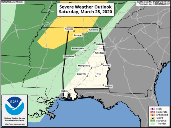
A Slight Risk for severe storms is up for locations north of a line from just north of Detroit (Lamar County) to Decatur (Morgan County) to New Market (Madison County). A Marginal Risk stretches to the south and east of that to as far south as just north of Geiger (Sumter County) to Kimberly (Jefferson County) to just east of Ider (Dekalb County). Isolated damaging winds up to 60 MPH and hail up to one-inch in diameter may be possible in the risk locations. A brief tornado may be possible in the Slight Risk locations as the better dynamics and forcing will be closer to that area.
Before all of the action, much of the day on Saturday will be great and very warm. We’ll start off with some clouds, but clearing will occur by afternoon and we’ll have a good supply of sunshine. Clouds will move back in around or just after sunset. Afternoon highs will be in the mid to upper 80s for most across Central Alabama. I wouldn’t be surprised if someone hits 90 degrees in the southern or southeastern parts of the area.
RAIN MOVES OUT ON SUNDAY
We’ll have some lingering rain and a thunderstorm or two leftover during the morning hours on Sunday as the cold front continues to move out of the area. By midday, all of Central Alabama will be dry and we’ll get some good breaks in the clouds. Unfortunately, skies will not clear out all of the way before sunset and clouds will move back in during the night. Highs will be in the mid-70s to the lower 80s across the area from northwest to southeast.
RAIN/STORMS MOVE BACK IN STARTING ON LATE MONDAY
Nearly all of the daylight hours on Monday across the area will be dry but skies will remain mostly cloudy as a low will be sliding eastward toward Central Alabama. showers and thunderstorms will begin moving into the western parts of the area during the evening and night-time hours. Nothing strong or severe expected at this time. Highs will be in the upper 60s to the lower 80s across the area from northwest to southeast.
STORMS TO START THE DAY ON TUESDAY
At sunrise on Tuesday, the low will be centered over the Mississippi River at the southeastern parts of Arkansas and the northwestern parts of Mississippi. The low will eventually move through the northern parts of the area throughout the morning and into the early afternoon hours, bring rain and thunderstorms to the area. The good news is that we are not expecting a big severe event with this system, but a strong to briefly severe storm is not out of the question. Much of the activity will be out of the area by sunset, but a leftover shower or two may be possible for a few hours longer. Highs will be in the upper 60s to the upper 70s.
DRY WITH COOLER TEMPERATURES TO END OFF THE WORK WEEK
Wednesday will be a fantastic day with mostly clear skies and highs in the mid-60s to the lower 70s from northwest to southeast. Maybe a few more clouds on Thursday, but skies will be partly cloudy and we’ll remain dry with cool temperatures. Highs will be in the mid-60s to the lower 70s. A “wash and repeat” forecast for Friday as we’ll have partly cloudy skies and highs in the mid-60s to the lower 70s.
BEACH FORECAST
Even though the beaches across the Alabama and Florida Gulf Coasts are closed, you may still want to know what the weather will be like. Get the latest weather and rip current forecasts for the beaches from Bay St. Louis, Mississippi, to Panama City Beach, Florida, on our Beach Forecast Center page. There, you can select the forecast of the region that you are interested in.
ADVERTISE ON THE BLOG!
We had another fantastic year in 2019 with just over 17 million page views! That brings our total for the last 2 years close to 37 million page views! Don’t miss out! We can customize a creative, flexible, and affordable package that will suit your organization’s needs. Contact Bill Murray at (205) 687-0782.
E-FORECAST
Get the Alabama Wx Weather Blog’s Seven-Day Forecast delivered directly to your inbox by email twice daily. It is the most detailed weather forecast available in Central Alabama. Subscribe here… It’s free!
CONNECT WITH THE BLOG ON SOCIAL MEDIA
You can find the AlabamaWx Weather Blog on the major social media networks:
Facebook
Twitter
Instagram
WEATHERBRAINS
Don’t forget you can listen to our weekly 90 minute netcast anytime on the web at WeatherBrains.com or on Apple Podcasts, Stitcher, or Spotify.
For more weather news and information from Scott Martin and the rest of the James Spann team, visit AlabamaWx.com.


