James Spann: Possible severe storms in south Alabama, rain in the north
James Spann forecasts active weather for Alabama today from Alabama NewsCenter on Vimeo.
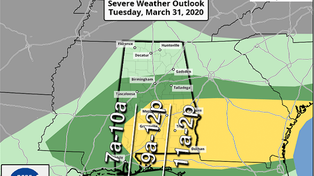
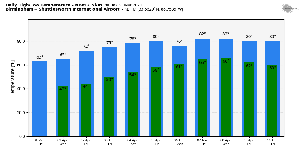
WET TUESDAY: A large mass of rain with a few elevated thunderstorms will move across the northern half of Alabama today. The air will be cool and stable, with temperatures holding in the 50s most of the day, and severe storms are not expected. However, strong to severe storms are likely over south Alabama. The Storm Prediction Center continues to define a slight risk (level 2 of 5) for most of south Alabama, east of a line from Uniontown to Bay Minette.
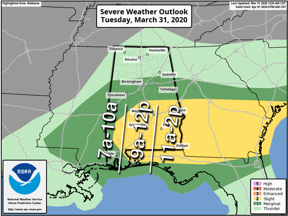
We believe the highest risk will be in areas southeast of Montgomery; storms there will be capable of producing large hail, strong winds and possibly a few tornadoes. This will be a fast-moving system; the threat of severe storms will end there by early afternoon. If you live in southeast Alabama, be sure you have a way of hearing severe weather warnings today if they are needed. Rain amounts statewide will be around one-half inch, with isolated heavier amounts to one inch.
REST OF THE WEEK: The sky will clear tonight, and Wednesday morning will be pretty chilly over the northern third of the state, where temperatures will dip into the mid to upper 30s. We can’t rule out the chance of frost for the colder spots and protected areas. Then, during the day we expect a sunny sky with a high in the mid 60s. The weather stays dry for the rest of the week; we rise into the low 70s Thursday, followed by mid 70s Friday.
THE ALABAMA WEEKEND: Saturday looks generally dry and pleasant with a partly sunny sky; temperatures will rise into the 75- to 80-degree range. On Sunday, expect a mix of sun and clouds with a high around 80; a few scattered showers are possible, but for now we don’t expect anything really widespread.
NEXT WEEK: Monday and Tuesday look rather unsettled, with a pretty good chance of showers and thunderstorms both days. The air will be pretty unstable by Tuesday, and we will keep an eye on the event for severe weather potential in coming days. The latter half of the week looks mostly dry and warm.
ON THIS DATE IN 1973: A devastating tornado took a nearly continuous 83-mile path through north central Georgia, causing more than $113 million damage, the highest total on record for a natural disaster in the state at that time. It touched down first in Jonesboro around 4:30 p.m. The tornado badly damaged homes in Conyers and Monroe, but the worst damage occurred in Athens. Two people were killed in a trailer park and at least 70 others were injured. Several businesses, including a truck stop, were destroyed.
ON THIS DATE IN 2016: Thunderstorms began forming across Mississippi by mid-afternoon, spreading east into western Alabama by early evening. A mix of supercells, storm clusters and bowing segments was observed through the duration of the event. Seven tornadoes touched down in Alabama — four EF-1s and three EF-0s.
BEACH FORECAST: Click here to see the AlabamaWx Beach Forecast Center page.
WEATHER BRAINS: You can listen to our weekly 90-minute show any time on your favorite podcast app. This is the show all about weather featuring many familiar voices, including the meteorologists at ABC 33/40.
CONNECT: You can find me on all of the major social networks:
Facebook
Twitter
Instagram
Pinterest
Snapchat: spannwx
For more weather news and information from James Spann and his team, visit AlabamaWx.com.


