Bill Murray: Alabama faces potential severe weather today, Easter Sunday

A stormy Easter Sunday is in store for Alabama as a powerful storm system affects our state and the South.
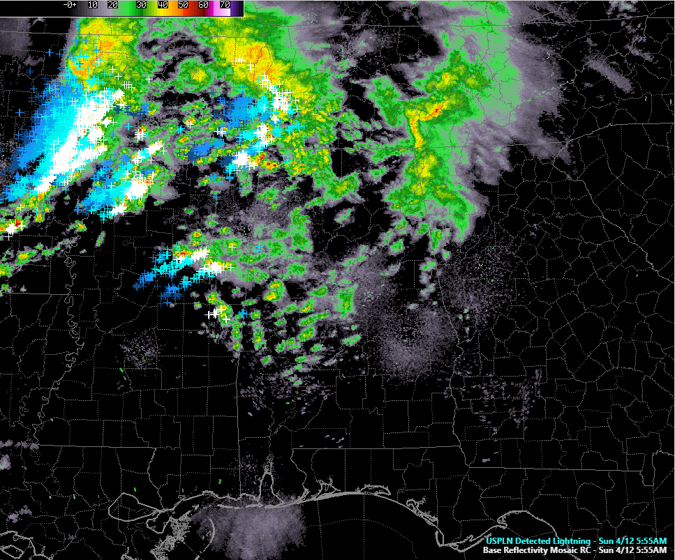
RADAR UPDATE AT 6 AM: Widespread showers are falling over northwestern Alabama at this hour, accompanying an upper-level disturbance that is pushing to our northwest. Temperatures are mostly in the 50s.
THE WARM FRONT: Not far behind these showers, more showers and storms are forming over central Mississippi ahead of a northward moving warm front. Lightning over central Mississippi is starting to work into northwest and west Alabama. The warm front will lift into north Alabama by early afternoon. Storms along the front have the potential to be severe, with hail and high wind, and a few tornadoes are possible as well.
THE WARM SECTOR/CAP: Behind the warm front, a warm, moist airmass will be simmering over Alabama and Mississippi. It may be capped by warm air aloft, which would keep a lid on thunderstorm development for a few hours. If it does, this would be like a lid on a pot of water on the stove. It could eventually boil over with the heating of the afternoon if it is strong enough or with the help of a passing upper-level disturbance. Instability values will be moderate too strong between 1,500-2,500 joules/kg, and shear values will be very high, so any storms that do form will have the potential to quickly go severe and produce large hail, damaging winds, and tornadoes. The tornadoes that do form could be strong and long tracked.
EVENING STORMS: As the trough to the west intensifies and pushes east, showers and storms will form over eastern Mississippi and Alabama by early evening. These storms will very likely become severe as well, with damaging winds, large hail, and strong, long-track tornadoes. A QLCS, or squall line, will push through during the late evening and early morning hours, exiting East Alabama around 2 a.m. The QLCS will be accompanied by damaging winds, hail, and more tornadoes.
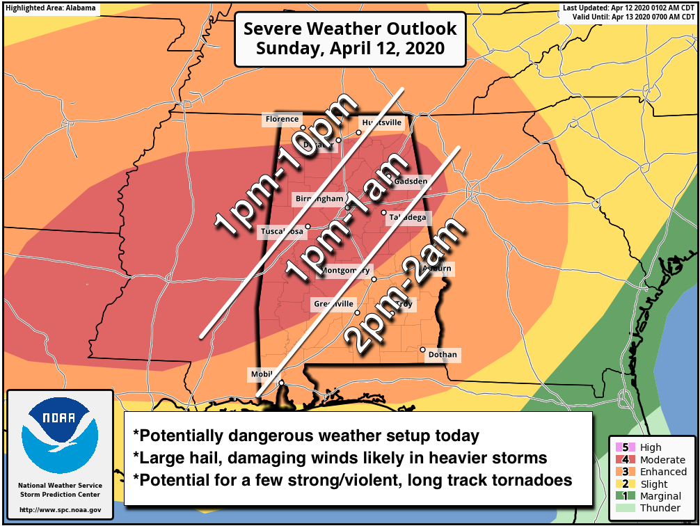
TIMING: The severe weather threat will commence as the warm front pushes through the area early this afternoon, and won’t end until the QLCS passes between 10 p.m. and 2 a.m. depending on your location.
TIME TO PREPARE: Now is the time to review your severe weather safety plan. Check your weather warning sources. Know where you safe place is. Remember that mobile and manufactured homes are not safe in tornadoes or damaging winds. Review our severe weather safety tips for more ideas.
COMMUNITY SHELTERS: Be aware that your normal community shelter may not be open because of the coronavirus crisis. Check to make sure before you go and make alternative plans if it won’t be. And be careful. When in doubt, realize that you must protect yourself from the tornado first and the virus second.
RAINFALL AMOUNTS: Rainfall amounts will average around one inch, but streaky higher amounts will be observed where stronger storms line up. Areas where thunderstorms train over the same locations could see 2-3 inches of rain. Flash flood watches are in effect for northwest and north Alabama.
IMPROVING CONDITIONS: Monday will be a breezy, mild day, with clearing skies. Monday evening will be mostly clear and cool, with lows in the lower and middle 40s. Tuesday will be sunny and cooler than normal with highs in the 60s.
MIDWEEK DISTURBANCE: A rapidly moving disturbance will pass to the north of us on Tuesday night and early Wednesday. It could produce a few showers across Tennessee and Alabama. Rain chances for us will be small and amounts if any will be light. Interestingly, snow could fall over the mountains of northeastern Tennessee, southwestern Virginia, and southern West Virginia.
THURSDAY AND FRIDAY PERFECTION: Thursday and Friday will be beautiful with morning lows in the 40s and highs in the 70s. Skies will be mostly sunny.
WEEKEND OUTLOOK: Another trough moving through the Midwest and Ohio Valley will trigger move showers and storms on Saturday or Sunday. There are differences in the two global models in terms of timing. Temperatures will be mild.
VOODOO COUNTRY: Look for another big rain event around the weekend of the 25th. The low pressure responsible for the event will be in a favorable position to produce severe weather, but it is too early to know whether the threat will be significant or not.
ADVERTISE WITH US: Deliver your message to a highly engaged audience by advertising on the AlabamaWX.com website. The site enjoyed 17.2 MILLION pageviews in the past 12 months. Don’t miss out! We can customize a creative, flexible and affordable package that will suit your organization’s needs. Contact me, Bill Murray, at (205) 687-0782 and let’s talk.
WEATHERBRAINS: This week, the panel will entertain two school administrators, including Whitt McGhee from Vestavia Hills, about how they deal with school closings during severe weather and winter weather. Check out the show at www.WeatherBrains.com. You can also subscribe on iTunes. You can watch the show live at live.bigbrainsmedia.com or on James’ YouTube Channel You will be able to see the show on the James Spann 24×7 weather channel on cable or directly over the air on the dot 2 feed.
ON THIS DATE IN 1979: Up to a foot of rain fell across North Alabama causing severe flooding. Two waves of rainfall inundated much of the state for hours and when it was finished, up to fourteen inches of rain had fallen across parts of West Alabama. Ten inches of rain was reported in the Tuscaloosa/Northport area. Six to eight inches fell across Jefferson County. Village Creek overflowed in the Avondale/Kingston and Ensley areas of Birmingham, forcing 1,500 people from their homes. The Warrior River crested nineteen feet above flood stage in Tuscaloosa . Much of the city of Northport was under water. Follow my weather history tweets on Twitter. I am @wxhistorian at Twitter.com.
For more weather news and information from Bill Murray ant the rest of the James Spann team, visit AlabamaWx.com.


