James Spann: Calmer weather for Alabama this week
James Spann forecasts cooler, drier weather ahead for Alabama from Alabama NewsCenter on Vimeo.
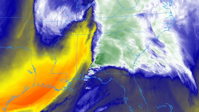
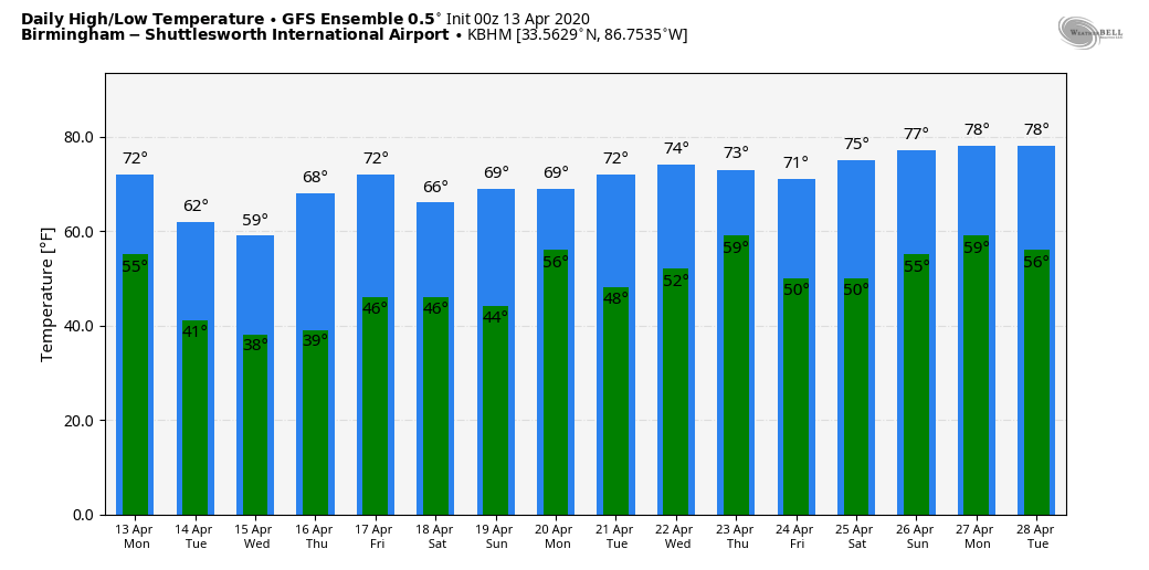
STORMS ARE GONE: After a long day and night of severe thunderstorms, drier air is over Alabama this morning. Clouds will linger today, but we do expect some sun at times this afternoon with a high in the mid 60s. The average high for Birmingham on April 13 is 74.
REST OF THE WEEK: Dry weather continues Tuesday through Thursday with partly sunny days and fair nights. The high will remain in the 60s Tuesday and Wednesday, and close to 70 Thursday. Mornings will be chilly; we project lows in the 34- to 42-degree range early Wednesday and Thursday morning with frost likely for colder pockets across north and central Alabama. Clouds return Friday and some rain is possible at times during the day, but for now we aren’t expecting anything too heavy, and there is no risk of severe thunderstorms. The high Friday will be in the low 70s.
THE ALABAMA WEEKEND: For now, Saturday looks dry with a high between 67 and 70; clouds increase Sunday, and there will be some risk of rain late in the day and into Sunday night as a wave of low pressure moves along the Gulf Coast. The high Sunday afternoon will be in the low 70s.
NEXT WEEK: The first half of the week looks dry with seasonal temperatures (highs in the low to mid 70s); showers return Thursday.
SUNDAY’S STORMS: Damage was reported in at least two dozen Alabama counties Sunday and Sunday night, with thousands of downed trees. While much of the damage was related to straight-line winds, it ls likely that a number of tornadoes touched down across the state, in places like Boaz in Marshall County, Carbon Hill in Walker County and Bagley near the Walker/Jefferson County line. National Weather Service survey teams will be out today to assess the damage and assign tornado ratings. There were a number of injuries, but to our knowledge there were no fatalities in Alabama. However, at least six people were killed by tornadoes in south Mississippi Sunday.
ON THIS DATE IN 1999: A two-mile-wide area of wind-driven hail pounded residences and farm equipment for about a five-mile stretch at least as far as State Highway 158 in west Texas near Midland/Odessa. Hail grew up to about golf-ball size and winds peaked at approximately 80 mph. The wind-driven hail broke windows in houses and blasted paint off the wooden siding. Utility crews stated that the winds downed 27 poles. The American Red Cross determined that 324 units were affected, with 18 mobile homes and four houses destroyed. About 50-60 families were at least temporarily displaced.
BEACH FORECAST: Click here to see the AlabamaWx Beach Forecast Center page.
WEATHER BRAINS: You can listen to our weekly 90-minute show anytime on your favorite podcast app. This is the show all about weather featuring many familiar voices, including the meteorologists at ABC 33/40.
CONNECT: You can find me on all of the major social networks:
Facebook
Twitter
Instagram
Pinterest
Snapchat: spannwx
For more weather news and information from James Spann and his team, visit AlabamaWx.


