James Spann: Dry weather, cold nights for Alabama through Thursday
James Spann forecasts a cool snap for Alabama the next few days from Alabama NewsCenter on Vimeo.
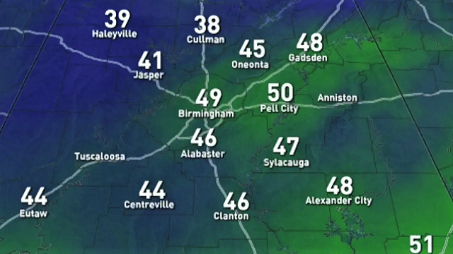
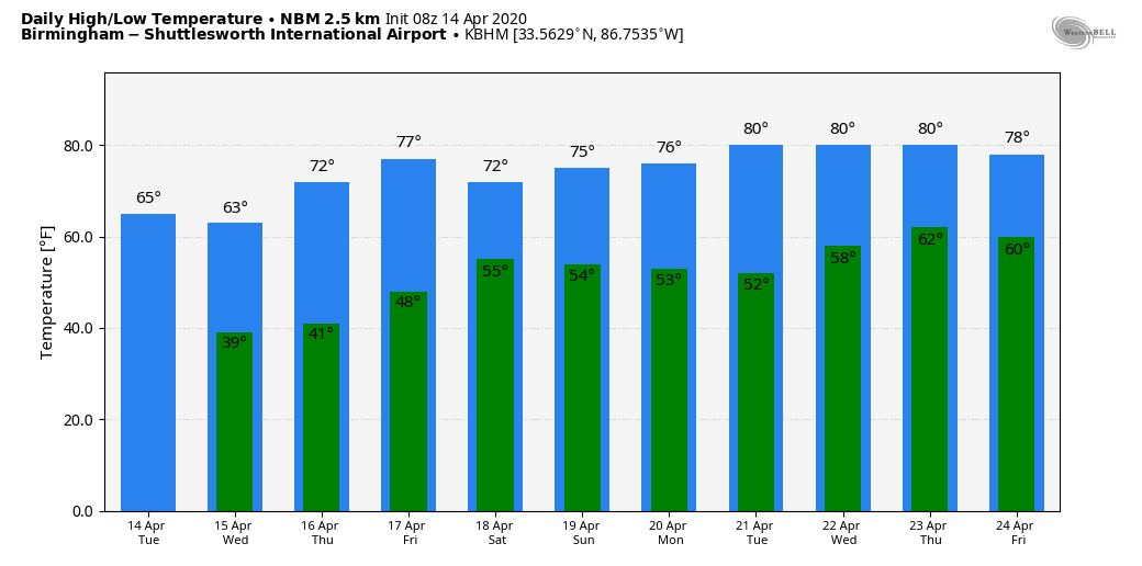
CALM WEATHER CONTINUES: Dry weather continues across Alabama through Thursday with partly to mostly sunny days and fair, cold nights. The high today will be in the 62- to 65-degree range, and some places over the Tennessee Valley won’t get out of the 50s. The average high for Birmingham on April 14 is 74.
We are projecting lows in the 32- to 40-degree range across north and central Alabama Wednesday and Thursday mornings with potential for lots of frost. Colder spots will have potential for a freeze. The high will be in the mid 60s Wednesday, then close to 70 on Thursday.
FRIDAY AND THE WEEKEND: A disturbance will bring some clouds into the state Friday along with the risk of some patchy, light rain, but moisture will be very limited and amounts will be very light. The high Friday will be in the mid 70s. Saturday looks like a very nice day as the weekend begins with ample sunshine and a high in the mid to upper 60s. Clouds return Sunday afternoon, and a wave passing along the Gulf Coast will bring rain back into the state Sunday night into Monday morning. It looks like the heaviest rain will be over the southern half of the state; for now, severe storms are not expected.
NEXT WEEK: The week will be warmer with highs around 80 by Tuesday and Wednesday. Midweek looks dry; some rain will likely return by Friday.
TORNADO SURVEYS: National Weather Service survey teams have identified seven tornadoes so far across Alabama that touched down Sunday or Sunday night:
- Boaz (Marshall County) — EF-2
- Oneonta (Blount County) — EF-2
- Carbon Hill (Walker County) — EF-1
- Johnson’s Crossing (Cullman County) — EF-1
- Shiloh (DeKalb County) — EF-1
- Locust Fork (Blount County) — EF-0
- Collinsville (DeKalb County) — EF-0
Survey work is far from complete; other tornado paths will likely be identified in coming days. To the west, NWS Jackson confirms a long-track tornado down at least 63 miles Sunday from Bassfield to Pachuta, Mississippi, with a preliminary rating of EF-4. The survey is not complete; the path could be longer.
ON THIS DATE IN 2019: An EF-1 tornado touched down at Troy, in Pike County. The tornado touched down in a mobile home community along Hunters Mountain Parkway, where several mobile homes sustained major damage. Around one dozen mobile homes were moved off their foundations, while several were observed to have rolled multiple times. Several of these homes were occupied, but only minor injuries were treated on scene. Two cars were also rolled in the area of greatest damage. The tornado moved northeast, crossing U.S. Highway 231, where power poles were snapped and several businesses sustained minor damage. It then moved just west of downtown Troy, where trees were uprooted and large branches were broken.
BEACH FORECAST: Click here to see the AlabamaWx Beach Forecast Center page.
WEATHER BRAINS: You can listen to our weekly 90-minute show anytime on your favorite podcast app. This is the show all about weather featuring many familiar voices, including the meteorologists at ABC 33/40.
CONNECT: You can find me on all of the major social networks:
Facebook
Twitter
Instagram
Pinterest
Snapchat: spannwx
For more weather news and information from James Spann and his team, visit AlabamaWx.


