James Spann: Warm, dry day for Alabama; showers, storms return Wednesday
James Spann forecasts rising temperatures for Alabama from Alabama NewsCenter on Vimeo.
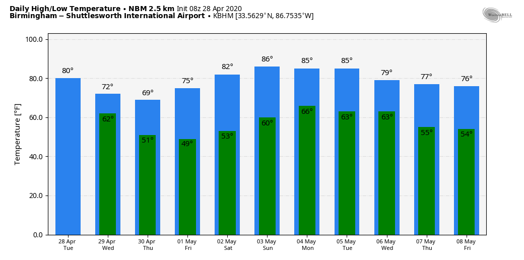
NICE WARM-UP: We are starting the day with temperatures in the upper 40s and low 50s, but we warm nicely today as we rise to near 80 degrees this afternoon. We note a few sprinkles on radar early this morning, but for most places today will be dry with a partly sunny sky. Clouds will increase tonight ahead of a developing storm system to the west.
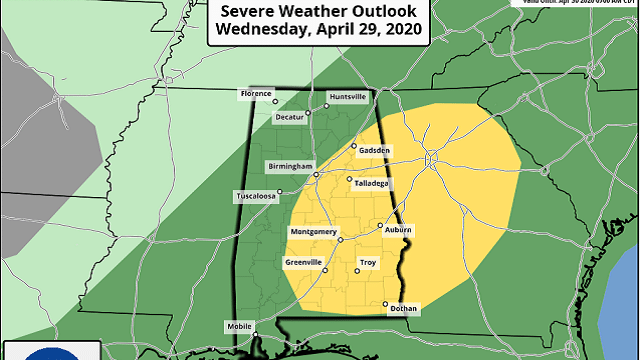
SHOWERS/STORMS WEDNESDAY: A weakening band of showers will push into northwest Alabama early Wednesday morning; heavier storms are possible over the southwest counties of the state, where strong, gusty winds are likely with the initial batch of storms. Additional showers and thunderstorms will redevelop Wednesday afternoon ahead of a cold front. The Storm Prediction Center has much of the state in a low-end marginal risk of severe weather (level 1 of 5), with a slight risk (level 2 of 5) for areas south and east of Birmingham.
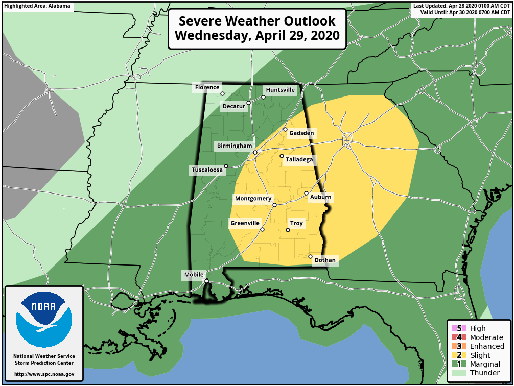
Strong to locally damaging winds appear to be the main threat across parts of east Alabama Wednesday afternoon and evening, in the slight-risk area. A tornado or two may also occur across this region as low-level flow will be sufficiently strong to encourage some updraft rotation, but the overall tornado threat is not especially high. Heavier storms will likely be found Wednesday afternoon east of I-65 between 1 and 7 p.m.
The bottom line is that this isn’t a major severe weather threat, but you always have to keep a close eye on convection in Alabama in late April, and we will do that. The high Wednesday will be in the low 70s for most communities, about 5 degrees below average for this time of the year.
THURSDAY THROUGH THE WEEKEND: The sky will clear Wednesday night, and we expect a good supply of sunshine Thursday and Friday with pleasant afternoons and cool nights. The high will be around 70 Thursday, followed by mid 70s Friday. Then, we are expecting the warmest weekend so far this year as temperatures rise into the low 80s Saturday and mid 80s Sunday. The sky will stay sunny Saturday, followed by a partly sunny day Sunday.
NEXT WEEK: Warm, dry weather continues Monday and Tuesday with highs in the 80s; then we will have a chance of showers and thunderstorms Wednesday. It’s too early to know if this system will pose a threat of severe thunderstorms.
ON THIS DATE IN 2014: A total of 28 tornadoes touched down across north and central Alabama, including EF-2 twisters that moved through parts of Adamsville, Graysville and Bessemer. An EF-1 touched down north of Birmingham at Kimberly. Two people were killed by an EF-3 tornado that night at a mobile home community in Limestone County. Another EF-3 in Russell County in east Alabama was responsible for 13 injuries.
ON THIS DATE IN 2002: During the evening, a violent F4 tornado carved a 64-mile path across southeast Maryland. The La Plata, Maryland tornado was part of a larger severe weather outbreak that began in the mid-Mississippi Valley early that day and spread across portions of the Ohio Valley and the Mid-Atlantic states. In Maryland, three deaths and 122 injuries were a direct result of the storm. Property damage exceeded $100 million.
WEATHER BRAINS: You can listen to our weekly 90-minute show any time on your favorite podcast app. This is the show all about weather featuring many familiar voices, including the meteorologists at ABC 33/40.
CONNECT: You can find me on all of the major social networks:
Facebook
Twitter
Instagram
Pinterest
Snapchat: spannwx
For more weather news and information from James Spann and his team, visit AlabamaWx.