James Spann: Windy, much cooler in Alabama today
James Spann has a cool midweek forecast for Alabama from Alabama NewsCenter on Vimeo.
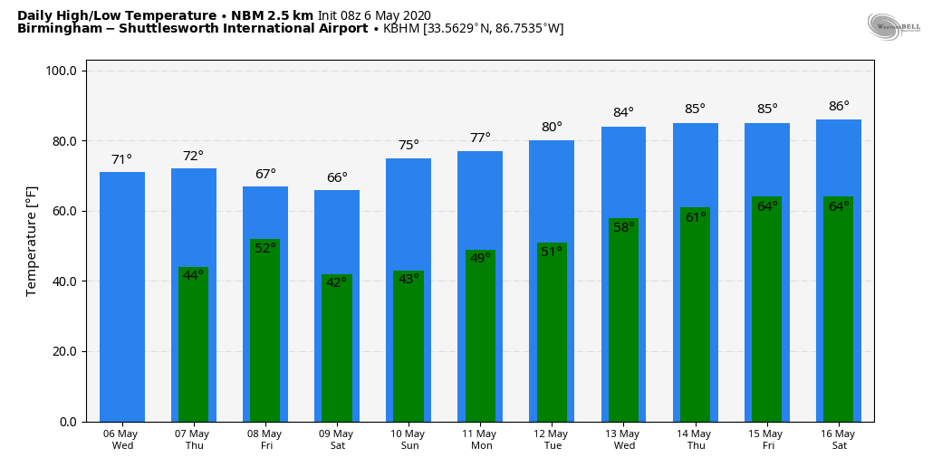
COOL MAY DAY: Following a cold front that passed through the state last night, today will be noticeably cooler, with a high between 65 and 70 degrees. A strong north wind will develop during the day, averaging 15-30 mph with gusts to 35; a wind advisory is in effect for much of the state. Some clouds will move down into north Alabama this afternoon, but the day will be dry. South Alabama will enjoy sunshine in full supply.
Winds will die down tonight, and by daybreak Thursday we will drop into the low to mid 40s with a clear sky. During the day Thursday, expect a bright, sunny day with a high in the low 70s. Clouds increase Thursday night.
FRIDAY AND THE WEEKEND: Another cold front will bring showers into the state Friday. Some thunder is possible, but there is little to no surface-based instability and no risk of severe thunderstorms. Rain amounts should be less than one-half inch. Then, another surge of unseasonably cooler air rolls into the state for the weekend. Saturday will be sunny and breezy with a high only in the mid 60s, followed by a sunny day on Sunday with a high in the low 70s.
Mornings will be cold. For most places, the low will be in the 38- to 43-degree range early Saturday and Sunday mornings. However, colder spots will dip into the mid 30s by daybreak Sunday with potential for a little scattered light frost. Here are the record lows for Birmingham:
- Saturday (May 9) — 40 (1984)
- Sunday (May 10) — 38 (1966)
We will be pretty close to those levels both mornings over the weekend.
NEXT WEEK: For now the weather looks rain-free through the week with a warming trend. We will see a high in the 70s Monday and Tuesday, followed by 80s over the latter half of the week.
There’s no sign of any severe weather or excessive rain issues for Alabama over the next seven to 10 days.
ON THIS DATE IN 1975: A massive tornado hit Omaha, Nebraska, killing three people, injuring 133 others and causing more than $250 million damage. The tornado struck during the late afternoon, moving northeastward through the industrial and residential areas of west-central Omaha and lifting over the northern section of the city. The twister, which cut a swath 10 miles long and as much as a quarter of a mile wide, was the most costly in U.S. history up to that time.
BEACH FORECAST: Click here to see the AlabamaWx Beach Forecast Center page.
WEATHER BRAINS: You can listen to our weekly 90-minute show any time on your favorite podcast app. This is the show all about weather featuring many familiar voices, including the meteorologists at ABC 33/40.
CONNECT: You can find me on the major social networks:
Facebook
Twitter
Instagram
Pinterest
Snapchat: spannwx
For more weather news and information from James Spann and his team, visit AlabamaWx.


