James Spann: Occasional showers, storms for Alabama through Friday
James Spann has the midweek forecast for Alabama from Alabama NewsCenter on Vimeo.
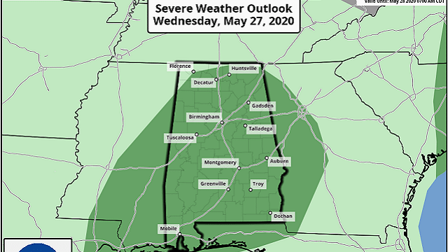
WET PATTERN CONTINUES: An upper low to the west of Alabama will continue to creep eastward in the coming days and keep the weather rather unsettled across the Deep South through Friday. Today will be mostly cloudy with periods of rain; a few strong thunderstorms are possible this afternoon if the air can become unstable. The Storm Prediction Center has most of the state in a low-end, marginal risk (level 1 out of 5) of severe thunderstorms.
Heavier storms this afternoon will be capable of producing small hail and strong winds. There is also a marginal risk for about the northern two-thirds of the state Thursday. If we can see some surface-based instability, then a few strong storms are possible Thursday afternoon.
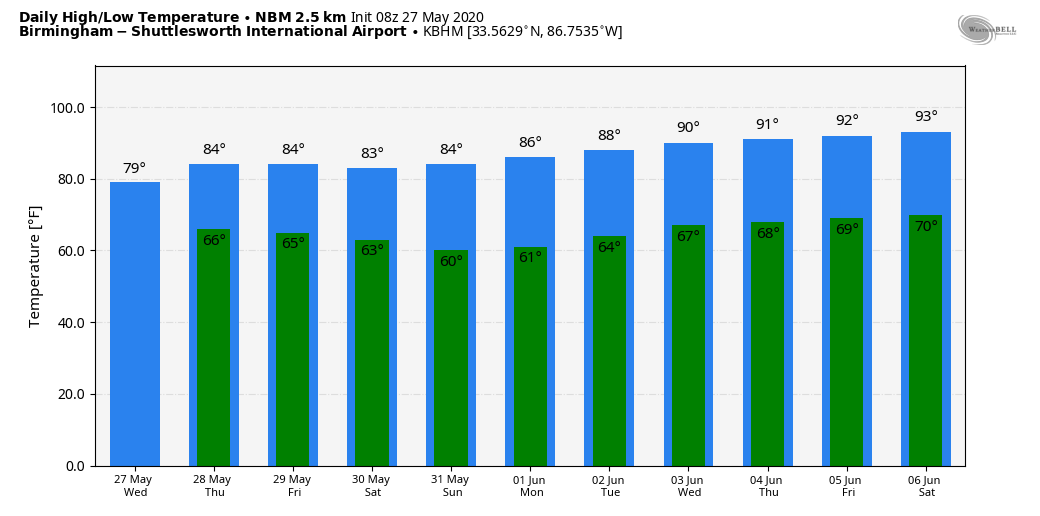
On Friday, scattered to numerous showers and thunderstorms remain likely. Temperatures will likely hold in the 70s today; then we expect a high in the low 80s Thursday and Friday.
THE ALABAMA WEEKEND: Much drier air rolls into Alabama Saturday. The latest global models are a bit faster with the arrival of the dry air, suggesting Saturday will be rain-free for most of the state, with lower humidity and a high in the low 80s. Sunday promises to be a delightful day for the end of May — sunshine in full supply with a morning low in the upper 50s, followed by a high around 80 degrees. Doesn’t get much nicer this time of the year.
NEXT WEEK: The week looks generally dry with a slow increase in heat and humidity; we will most likely reach the low 90s by Thursday and Friday.
TROPICS: An elongated area of low pressure just offshore of the northeast Florida and Georgia coasts and an associated upper-level disturbance are producing a large area of disorganized showers and thunderstorms. Although the disturbance has changed little in organization during the past several hours, some development is possible before it moves inland over the southeast U.S. by this afternoon. After the system is inland, tropical cyclone formation is not expected. Regardless of development, heavy rainfall could cause flash flooding over portions of the Carolinas on Wednesday. Gusty winds could also produce rough marine conditions and life-threatening surf and rip currents along the coasts of Georgia and the Carolinas through tonight.
ON THIS DATE IN 1973: A long-track F4 tornado touched down northeast of Demopolis and traveled northeastward. The tornado produced damage in Greensboro, Brent, Centreville, Montevallo, Columbiana, Wilsonville, Childersburg and many areas in between before lifting near Mount Cheaha. In Greensboro, 72 people were injured and one person was killed. Ninety percent of the town of Brent was destroyed; five people there were killed and 56 injured. In all, 216 buildings were destroyed, 570 buildings were damaged, 97 mobile homes were destroyed and 45 businesses were damaged or destroyed. More than 12,000 acres of timber was destroyed.
On the same day, May 27, 1973, an F3 tornado touched down northeast of the city of Tarrant and traveled through Center Point, where most of the damage from this storm occurred, including one fatality caused by the collapse of a home onto a family taking shelter in their basement. Thirty-two frame homes and 48 mobile homes were destroyed. More than 300 homes sustained minor damage in this area, as well. The storm then continued northeast, passing south of Springville, near St. Clair Springs, just to the north of Ashville and lifted near Gadsden.
BEACH FORECAST: Click here to see the AlabamaWx Beach Forecast Center page.
WEATHER BRAINS: You can listen to our weekly 90-minute show anytime on your favorite podcast app. This is the show all about weather featuring many familiar voices, including the meteorologists at ABC 33/40.
CONNECT: You can find me on the major social networks:
Facebook
Twitter
Instagram
Pinterest
Snapchat: spannwx
For more weather news and information from James Spann and his team, visit AlabamaWx.


