James Spann: Alabama showers, storms become a bit more scattered Thursday, Friday
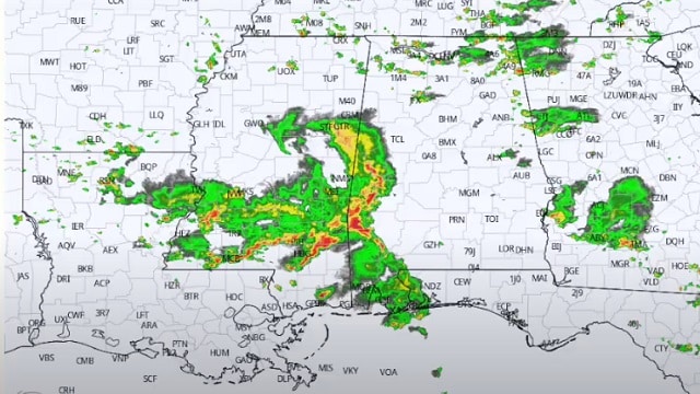
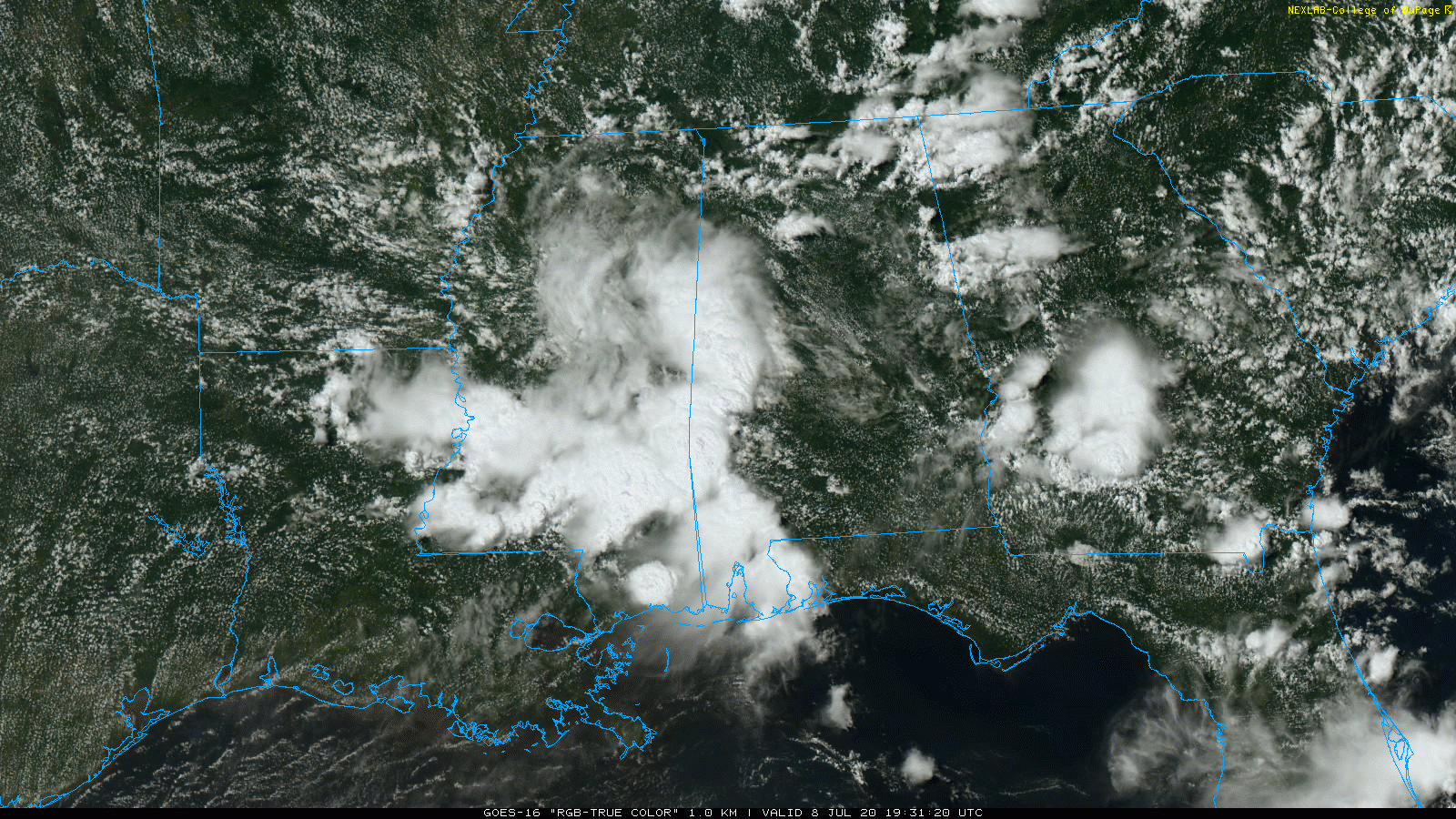
RADAR CHECK: In the tropical air over Alabama we have a number of showers and thunderstorms this afternoon, some producing heavy amounts of rain. Showers over the Tennessee Valley of north Alabama are moving very little, while the rain bands over the central counties are moving eastward. They will persist into the night.
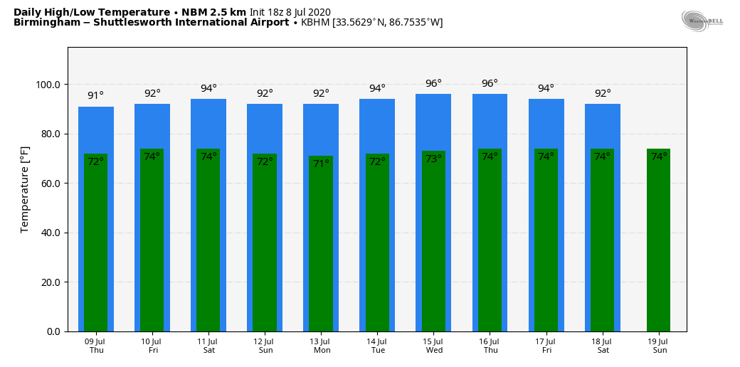
Temperatures are mostly in the mid 80s across the state, but where rain is falling we are seeing mid to upper 70s. The average high for Birmingham on July 8 is 91.
THURSDAY THROUGH THE WEEKEND: Heat levels will gradually rise in coming days as the upper trough over the region lifts away, and showers and storms will become more scattered. Look for a high around 90 Thursday followed by low 90s Friday, with the usual risk of random, scattered, mostly afternoon and evening showers and thunderstorms. Expect a good supply of sunshine Saturday and Sunday, with only isolated afternoon storms. Highs will be in the 91- to 95-degree range over the weekend.
We should mention we will have a northwest flow aloft pattern over the weekend, so any organized thunderstorm areas that form over states like Missouri and Arkansas will have the potential to roll into Alabama, but there’s no way of knowing if or when that will happen.
NEXT WEEK: The week looks like it will feature very routine midsummer weather for Alabama — partly sunny, hot, humid days with scattered, mostly afternoon and evening showers and thunderstorms. Highs will remain mostly in the low to mid 90s.
TROPICS: A broad area of low pressure near the coast of northeastern South Carolina continues to produce a large area of disorganized showers and thunderstorms over the adjacent Atlantic waters and portions of eastern North Carolina. The low is expected to move northeastward near or just offshore of the North Carolina Outer Banks on Thursday, and then turn north-northeastward and move along the mid-Atlantic coast Friday. Environmental conditions are expected to be conducive for development, and a tropical or subtropical cyclone is likely to form within the next day or so. Regardless of development, the system is expected to produce locally heavy rainfall that could cause some flash flooding across portions of eastern North Carolina, the coastal mid-Atlantic and southern New England during the next few days. Gusty winds are also possible along the North Carolina Outer Banks through Thursday and along the mid-Atlantic and southern New England coasts Friday and Saturday.
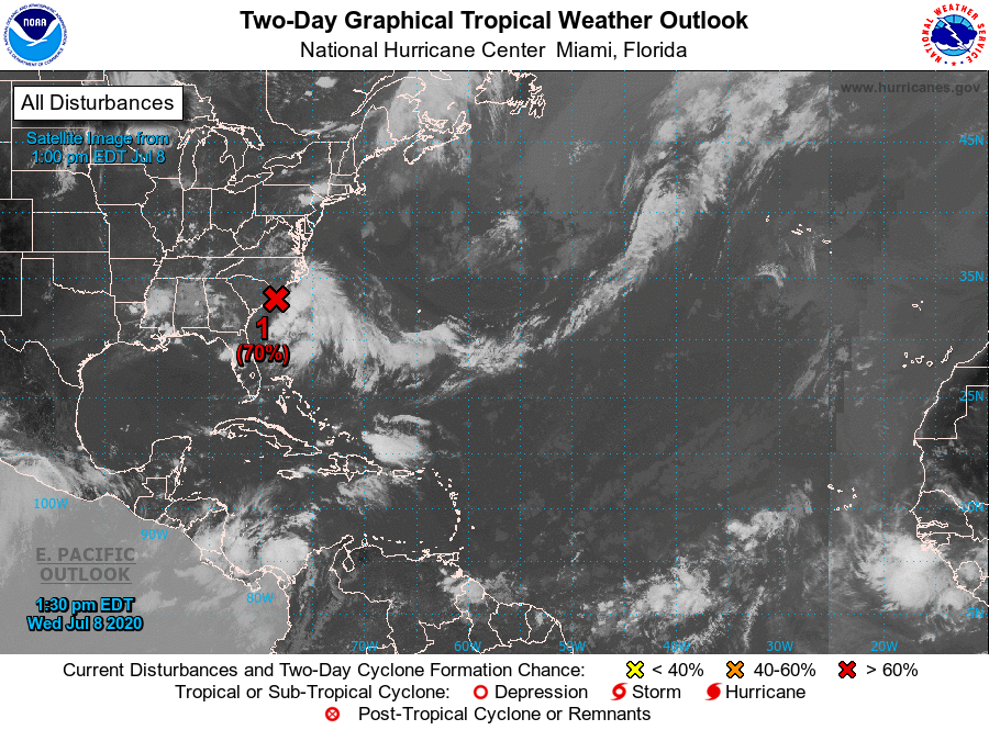
The rest of the Atlantic basin is quiet, including the Gulf of Mexico.
COMET NEOWISE: From WeatherBrains colleague Tony Rice — Comet C/2020 F3 (NEOWISE) has brightened to the point it is naked-eye visible. Some viewing tips:
- Look low on the north-northeastern horizon.
- The best visibility will be about an hour before sunrise.
- The comet will be lost in the brightening sky as sunrise draws nearer.
- The clearer your northeastern horizon, the earlier you’ll spot the comet and the brighter it will be.
- Be aware of light pollution sources. Viewers to the south and west of metropolitan areas are going to have a bigger challenge seeing the comet than those on the north and east.
ON THIS DATE IN 2003: What may be the world’s highest dew point temperature was recorded at Dhahran, Saudi Arabia, in the Persian Gulf. A dew point of 95 degrees was recorded at 3 p.m. while the air temperature was 108 degrees. The apparent temperature at that time would have been 172 degrees.
BEACH FORECAST: Click here to see the AlabamaWx Beach Forecast Center page.
WEATHER BRAINS: You can listen to our weekly 90-minute show anytime on your favorite podcast app. This is the show all about weather featuring many familiar voices, including the meteorologists at ABC 33/40.
CONNECT: You can find me on the major social networks:
Facebook
Twitter
Instagram
Pinterest
Snapchat: spannwx
For more weather news and information from James Spann and his team, visit AlabamaWx.


