James Spann: Unsettled weather for Alabama this week

James Spann forecasts a wetter week for Alabama with lower temperatures from Alabama NewsCenter on Vimeo.
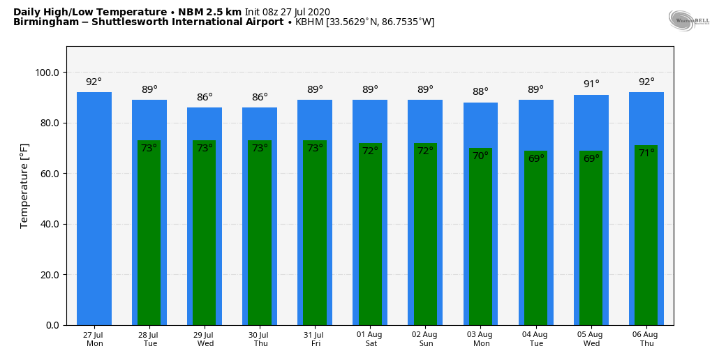
WET SUMMER PATTERN THIS WEEK: Deep, tropical moisture with high precipitable water values will cover Alabama this week, setting the stage for rather unsettled weather conditions. Today, look for a mix of sun and clouds with scattered showers and thunderstorms developing again this afternoon and tonight. The chance of any one spot getting wet is 50-60%, and the high this afternoon will be in the 88- to 91-degree range for most places. The average high for Birmingham on July 27 is 91.
REST OF THE WEEK: A broad upper trough will develop over the region, and we will forecast numerous showers and thunderstorms Tuesday through Thursday. While most of them will come during the afternoon and evening, we can’t rule out some rain during the late night and morning as well. The sky will feature more clouds than sun, and highs will be only in the mid 80s. There’s some evidence showers will thin out a bit on Friday with a high in the upper 80s.
THE ALABAMA WEEKEND: For Saturday and Sunday, most of the sun will come during the morning and we will have showers and thunderstorms both days, mainly from about noon until midnight. Afternoon highs will be in the 87- to 90-degree range, still below average for early August in Alabama.
We won’t see much change through next week. Look for partly sunny days with scattered showers and thunderstorms daily, mostly during the afternoon and evening hours. There’s no sign of any excessive heat issues for the state; highs will remain in the upper 80s and low 90s.
TROPICS: Invest 92L, in the Atlantic between the coast of Africa and the Lesser Antilles, is expected to become Isaias soon and most likely will ramp up to hurricane strength in three to four days. Using ensemble output from global models, this will likely pass near or just north of the Leeward Islands and Puerto Rico late this week as it gains latitude, then recurve just off the East Coast of the U.S. in seven to 10 days. Of course, it is too early to know the ultimate track and intensity of the system. But I would say odds are high this won’t be a Gulf of Mexico threat.
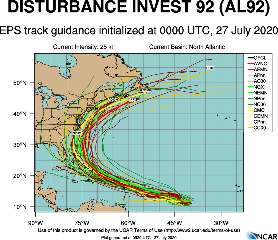
The rest of the Atlantic basin, for now, is quiet. No systems threaten the Gulf of Mexico for at least five days.
TENNESSEE RIVER WATERSPOUT: A summer shower was responsible for producing a brief waterspout over the Tennessee River at Decatur late Sunday afternoon. This is much like the fair-weather waterspouts on the Gulf Coast; they are short-lived and rarely cause any really significant damage. It lasted for only about five minutes before it dissipated.
ON THIS DATE IN 1943: A surprise Category 2 hurricane moved ashore near Galveston, Texas. Because of World War II all news underwent censorship, including any weather reports, making this a surprise storm. The hurricane killed 19 people and caused millions of dollars in damages. Lt. Col. Joe Duckworth and Lt. Ralph O’Hair flew an AT-6 Texan into the eye of the hurricane, the first flight into the eye of a storm.
BEACH FORECAST: Click here to see the AlabamaWx Beach Forecast Center page.
WEATHER BRAINS: You can listen to our weekly 90-minute show anytime on your favorite podcast app. This is the show all about weather featuring many familiar voices, including the meteorologists at ABC 33/40.
CONNECT: You can find me on the major social networks:
Facebook
Twitter
Instagram
Pinterest
Snapchat: spannwx
For more weather news and information from James Spann and his team, visit AlabamaWx.


