Scott Martin: Scattered storms possible in Alabama today; Isaias continues toward U.S.
THE WEEKEND WEATHER: We’ll have a cold front beginning to push its way across Alabama throughout the day today, but it will struggle and will only make it just past the I-65 corridor by the end of the evening. We’ll have a few showers possible during the morning, but scattered showers and storms will develop with the heating of the day along and ahead of the front. Widespread severe weather is not expected, but a few storms may become strong, with gusty winds and small hail. Highs will be in the mid-80s to the lower 90s from northwest to southeast.
The cold front will finally make its way through Alabama on Sunday, but before it leaves a few scattered showers and storms will be possible along and ahead of it, especially over extreme eastern and southeastern Alabama. The rest of the state looks to stay dry with highs in the mid-80s to the lower 90s.
THE WORK WEEK: We’ll have another cold front approaching Alabama from the west and northwest on Monday; it will move into the northern half of the state late in the day. While we do not expect much in the way of showers and storms with this front, we will have a very small chance of an isolated shower or two during the afternoon and evening. Highs will be in the upper 80s to the lower 90s.
The cold front will start off over the I-20 corridor on Tuesday morning and will move southward through the rest of the state throughout the day. While a brief isolated shower or two may be possible, it looks like it will be another mainly dry day. Highs will be in the mid-80s to the lower 90s.
The front will be along the Gulf Coast on Wednesday, which will give us another mainly dry day across central Alabama, with only a very small chance of an isolated shower during the afternoon. Highs will be in the mid-80s to the lower 90s.
We look to stay dry to end out the first work week of August. We’ll have plenty of sunshine and a little lower humidity on Thursday and Friday. Highs both days will be in the upper 80s to the mid-90s.
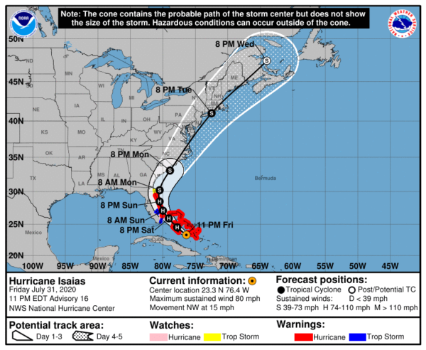
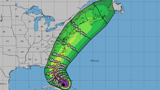
TROPICS: As of the 10 p.m. Friday update from the National Hurricane Center, Hurricane Isaias had maximum sustained winds at 80 mph and was moving to the northwest at 15 mph. The pressure was down to 987 millibars. Isaias was about 135 miles to the south-southeast of Nassau, Bahamas.
Hurricane warnings are up for the northwestern and central Bahamas, along with a part of the Florida east coast from Boca Raton to the Volusia/Brevard county line. A hurricane watch is up from Hallandale Beach to just south of Boca Raton. Tropical storm warnings are up from just north of Ocean Reef to just south of Boca Raton, along with all of Lake Okeechobee. A tropical storm watch is up from the Flagler/Volusia county line to Ponte Vedra Beach. A storm surge watch is up from Jupiter Inlet to Ponte Vedra Beach.
A general northwestward motion with some decrease in forward speed is expected for the next day or so, followed by a turn toward the north-northwest by late Sunday. On the forecast track, the center of Isaias will move near or over the northwestern Bahamas today and near the east coast of the Florida peninsula this afternoon through Sunday.
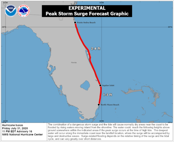
Storm surge could be as high as 2-4 feet from Jupiter Inlet to Ponte Verde, and as high as 1-3 feet from North Miami Beach to Jupiter Inlet.
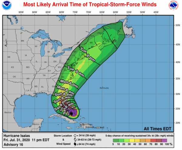
Hurricane conditions are expected to reach the coast within the hurricane warning area in Florida late today and tonight, and will spread northward through Sunday.
There will be plenty of rainfall along the coast:
- 2-4 inches with isolated totals up to 6 inches in south to east-central Florida.
- 1-2 inches for northeast Florida and up into coastal Georgia.
- 2-4 inches with isolated totals up to 6 inches for the Carolinas and into the mid-Atlantic, along with portions of the southern and central Appalachians.
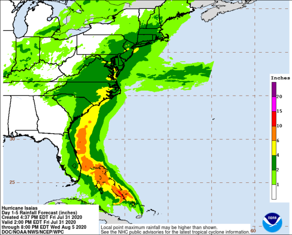
Flash flooding, urban flooding and minor river flooding will be possible across the eastern Carolinas and into Virginia.
Rough surf and life-threatening rip currents will spread along the east coast of Florida and the southeastern U.S. coast today.
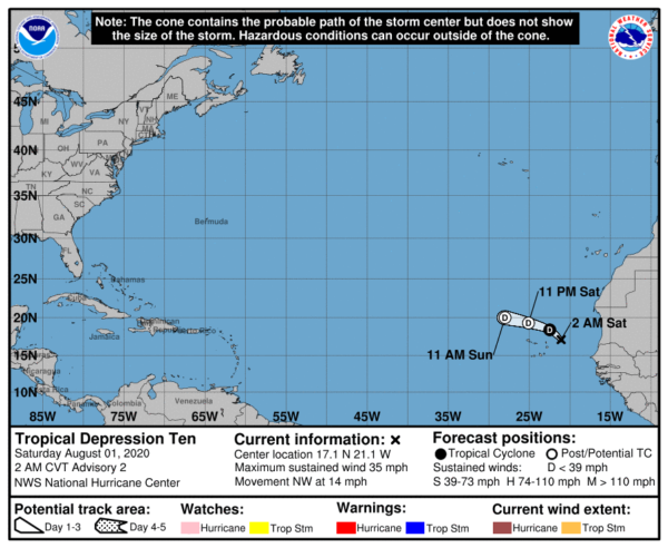
We also have Tropical Depression 10 around 205 miles east-northeast of the Cabo Verde Islands, moving northwest at 14 mph. A turn toward the west-northwest or west is expected by this afternoon, and it may briefly strengthen just enough to become a tropical storm. TD-10 is forecast to weaken and become a remnant low within the next 24 hours. Don’t blink, or you will miss it. The J-name is Josephine if it does strengthen enough to gain a name.
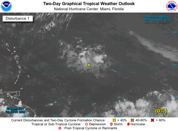
We also have a disturbance that is centered about 700 miles east of the Lesser Antilles. There is a small possibility of some slow development over the next few days, but this one will recurve back out to the north and away from land. Nothing is going on in the Gulf of Mexico at this point.
ON THIS DATE IN 1989: Hurricane Chantal made landfall along the upper Texas coast about sunrise. Chantal deluged parts of Galveston Island and southeastern Texas with 8 to 12 inches of rain. Unofficial totals ranged up to 20 inches. Winds gusted to 82 mph at Galveston and reached 76 mph in the Houston area. Tides were 5 to 7 feet high. The hurricane claimed two lives and caused $100 million damage.
BEACH FORECAST CENTER: Get the latest weather and rip current forecasts for the beaches from Bay St. Louis, Mississippi, to Panama City Beach, Florida, on our Beach Forecast Center page. There, you can select the forecast of the region you are interested in.
For more weather news and information from James Spann, Scott Martin and other members of the James Spann team, visit AlabamaWx.


