James Spann: Sun, heat, storms for Alabama this week
James Spann forecasts typical August weather for Alabama from Alabama NewsCenter on Vimeo.
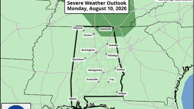
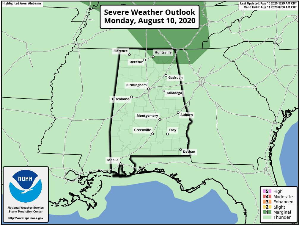
CLASSIC AUGUST WEATHER THIS WEEK: We expect a general increase in the number of scattered showers and thunderstorms across Alabama later today and tonight, mostly between 1 and 9 p.m., and the air will be a bit more unstable and moisture a little deeper. Odds of any one spot getting wet later today will be 40-50%, with the higher coverage over the eastern half of the state. A few strong storms are possible over northeast Alabama, where the Storm Prediction Center has a marginal risk (level 1 of 5) in place.
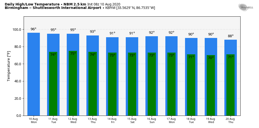
Otherwise, today will be partly sunny, hot and humid with a high between 92 and 95 degrees for most communities. The average high for Birmingham on Aug. 10 is 91.
REST OF THE WEEK: We will cover the week with the classic summer forecast — partly sunny, hot days with random, scattered, mostly afternoon and evening showers and thunderstorms. Global models suggest the higher coverage of showers will come on Thursday and Friday; highs will be in the low to mid 90s Tuesday and Wednesday and close to 90 Thursday and Friday.
THE ALABAMA WEEKEND: We are forecasting scattered to numerous showers and thunderstorms Saturday with a mix of sun and clouds; showers should become fewer in number Sunday as the air is expected to be drier. Highs over the weekend will stay close to 90 degrees.
NEXT WEEK: No reason to depart from the standard August formula next week. Look for partly sunny days with scattered, mostly afternoon and evening showers and thunderstorms. Highs will be at or just over 90 degrees.
TROPICS: Showers and thunderstorms continue to show signs of organization in association with a vigorous tropical wave several hundred miles west-southwest of the Cabo Verde Islands. Environmental conditions are expected to be somewhat conducive for additional development to occur, and a tropical depression is likely to form during the next day or two while the disturbance moves generally westward at around 15 mph across the tropical Atlantic. Conditions are forecast to become less conducive for development by the end of the week. This is far from the U.S. and well east of the Lesser Antilles. The rest of the Atlantic basin is quiet.
ON THIS DATE IN 1856: A hurricane destroyed Isle Dernieres or Last Island, a pleasure resort south-southwest of New Orleans. The highest points of the island were under five feet of water. The resort hotel was destroyed, along with the island’s gambling establishments. More than 200 people perished, and the island lost all its vegetation and split in half. Only one cow remained on the island after the catastrophe. The Last Island is now just a haven for pelicans and other seabirds. The steamer Nautilus foundered during the storm. The lone survivor clung to a bale of cotton and washed ashore sometime later.
BEACH FORECAST: Click here to see the AlabamaWx Beach Forecast Center page.
WEATHER BRAINS: You can listen to our weekly 90-minute show anytime on your favorite podcast app. This is the show all about weather featuring many familiar voices, including the meteorologists at ABC 33/40.
CONNECT: You can find me on the major social networks:
Facebook
Twitter
Instagram
Pinterest
Snapchat: spannwx
For more weather news and information from James Spann and his team, visit AlabamaWx.


