James Spann: Dangerous Laura headed for northwest Gulf Coast; drier day for Alabama
James Spann has the latest on Laura and the Alabama forecast from Alabama NewsCenter on Vimeo.
RADAR CHECK: We have a batch of rain and thunderstorms over northwest Alabama early this morning, but a decent part of this day should be dry across the state, with only widely scattered showers or storms this afternoon. The sky will be partly sunny, and the high will be in the upper 80s for most communities. Don’t expect much change Thursday; the main impact from Laura (in terms of wind and rain) will remain well to the west. We will have a mix of sun and clouds with a few widely scattered showers or thunderstorms by mid to late afternoon. Thursday’s high will be in the low 90s.
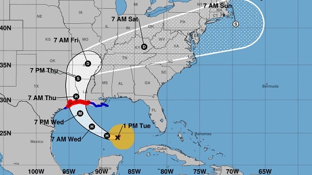
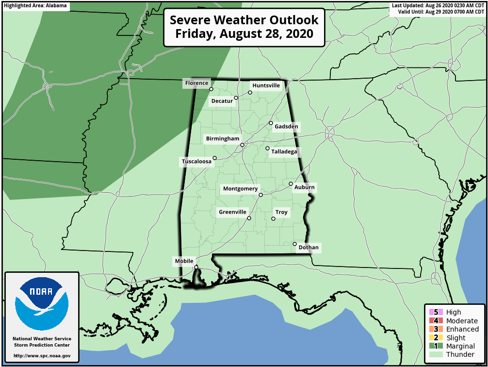
FRIDAY: Laura will be turning eastward, north of Alabama, and there could be a window where a low-end risk of a brief tornado or two is possible over northwest Alabama during the day Friday. For now the Storm Prediction Center has the northwest corner of the state in a marginal risk (level 1 of 5) for this possibility.
The sky will be occasionally cloudy with a few showers and storms likely Friday and Friday night, mainly over the northern half of the state.
THE ALABAMA WEEKEND: Laura will pull a deep pool of tropical moisture up into the state, and we expect scattered to numerous showers and thunderstorms Saturday and Sunday. The window for most of the rain comes from noon to midnight, but we can’t rule out a few late-night or morning showers. Expect more clouds than sun both days with highs in the mid to upper 80s.
NEXT WEEK: Moist, unstable air will remain in place through the week, so we will have some risk of showers and storms daily. Highs will be mostly in the 85- to 90-degree range.

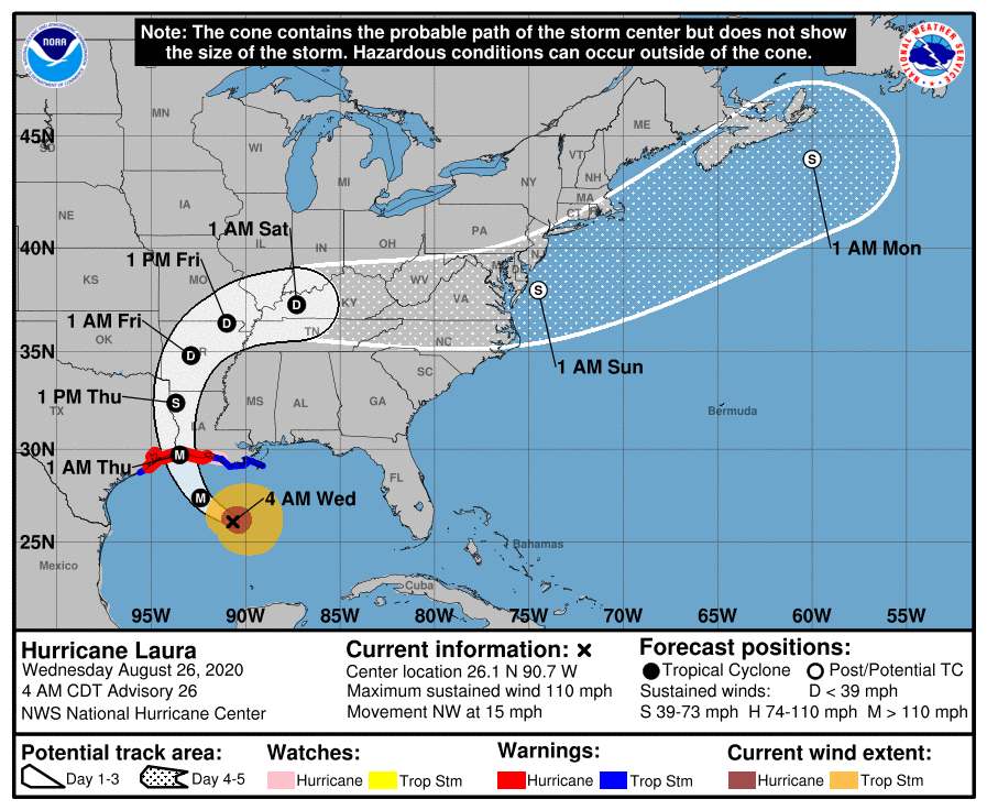
LAURA: The hurricane in the Gulf strengthened rapidly overnight and is now packing sustained winds of 110 mph. The circulation center is about 300 miles south/southeast of Lake Charles, Louisiana, and landfall comes tonight near Sabine Pass, the Texas/Louisiana border. Laura is now forecast to be at Category 4 strength at the time of landfall (sustained winds in excess of 130 mph).
Key messages from the National Hurricane Center:
- Life-threatening storm surge with large, dangerous waves is expected to produce potentially catastrophic damage from San Luis Pass, Texas, to the mouth of the Mississippi River, including areas inside the Port Arthur Hurricane Flood Protection system. This surge could penetrate up to 30 miles inland from the immediate coastline in southwestern Louisiana and southeastern Texas. Actions to protect life and property should be rushed to completion, as water levels will begin to rise later today.
- Hurricane-force winds are expected tonight in the warning area from San Luis Pass, Texas, to west of Morgan City, Louisiana, and the strongest winds associated with Laura’s eyewall will occur somewhere within this area. Hurricane-force winds and widespread damaging wind gusts are also expected to spread well inland into portions of eastern Texas and western Louisiana early Thursday.
- Widespread flash flooding along small streams, urban areas and roadways is expected to begin this afternoon into Thursday from far eastern Texas across Louisiana and Arkansas. This will also lead to minor to isolated moderate freshwater river flooding. The heavy rainfall threat and localized flash and urban flooding potential will spread northeastward into the middle Mississippi, lower Ohio and Tennessee Valleys Friday night and Saturday.
This is part of the discussion from the early-morning hurricane local action statement from National Weather Service Houston concerning impact in the hurricane warning area (not the city of Houston):
“Potential impacts include: structural damage to sturdy buildings, some with complete roof and wall failures. Complete destruction of mobile homes. Damage greatly accentuated by large airborne projectiles. Locations may be uninhabitable for weeks or months. Numerous large trees snapped or uprooted along with fences and roadway signs blown over. Many roads impassable from large debris, and more within urban or heavily wooded places. Many bridges, causeways, and access routes impassable. Widespread power and communications outages.”
CENTRAL GULF COAST: Dangerous rip currents will continue along the coast from Gulf Shores over to Panama City Beach through Friday, but there will be little direct weather impact other than a stiff south breeze and tropical showers from time to time. There will be a pretty decent amount of sun each day along the central Gulf Coast.
The rest of the Atlantic basin is very quiet this morning.
ON THIS DATE IN 1992: Hurricane Andrew made a second landfall near Burns Point, Louisiana, as a Category 3 hurricane. Morgan City, Louisiana, recorded sustained winds of 92 mph with a peak gust of 108 mph. Hammond, Louisiana, was deluged with 11.92 inches of rain. As Andrew moved inland and weakened, it spawned 47 tornadoes from this date through Aug. 28 from the South to the Mid-Atlantic States.
BEACH FORECAST: Click here to see the AlabamaWx Beach Forecast Center page.
WEATHER BRAINS: You can listen to our weekly 90-minute show anytime on your favorite podcast app. This is the show all about weather featuring many familiar voices, including the meteorologists at ABC 33/40.
CONNECT: You can find me on the major social networks:
Facebook
Twitter
Instagram
Pinterest
Snapchat: spannwx
For more weather news and information from James Spann and his team, visit AlabamaWx.


