Scott Martin: Lower humidity, no rain for Alabama throughout the weekend
THIS WEEKEND: Drier air will be moving into Alabama today and we’ll have mostly sunny skies throughout the day. Afternoon highs will top out in the mid-80s to the mid-90s from northwest to southeast.
The story will be much the same for Sunday — lower humidity levels until the evening, when moisture will start to return with an easterly flow. It will be another mostly sunny day with highs reaching the upper 80s to the lower 90s.
LABOR DAY: While we will have a little more humidity in the air, we look to stay dry for the holiday, so, be sure to get outside and enjoy the nice weather. Skies will be mostly clear and highs will again be in the upper 80s to the lower 90s.
TUESDAY AND WEDNESDAY: The latest Global Forecast System shows deeper moisture moving up into Alabama for Tuesday and Wednesday and a good chance of showers and thunderstorms being possible, mainly during the afternoons. The European model is showing a much drier solution for the same time period. We’ll go with a small chance of showers and storms for the afternoons. Highs on both days will be in the upper 80s to the lower 90s.
THURSDAY AND FRIDAY: A southwesterly flow sets up over Alabama that will bring an increased risk of scattered showers and thunderstorms, mainly during the afternoon and evening hours. Thursday’s highs will be in the mid-80s to the lower 90s. Friday’s highs will be in the lower 80s to the upper 80s from northwest to southeast.
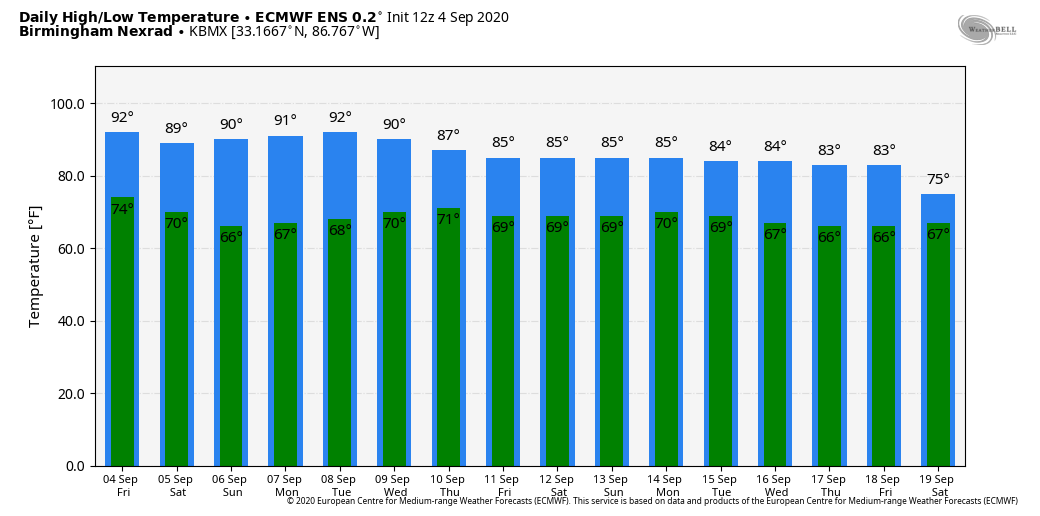
VOODOO LAND: The long-range models do not show the cooler air arriving in Alabama until Saturday, Sept. 12. Using the Birmingham Nexrad station as the focal point, as it is nearly in the center of Alabama, we see highs in the mid to lower 80s starting on the 12th and potentially dropping into the mid-70s just one week later. This could all change, as it is out there in Voodoo Land.
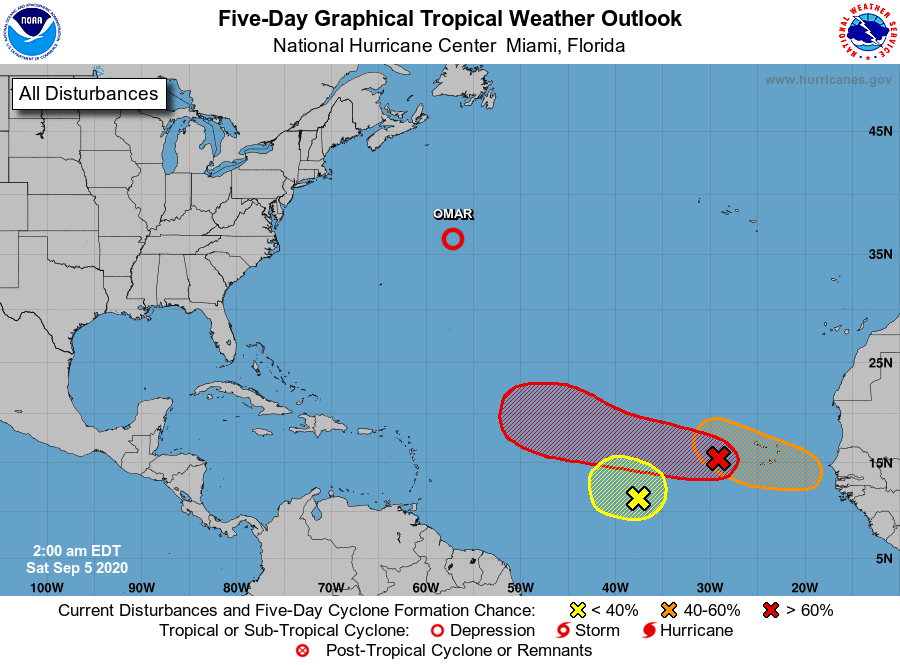
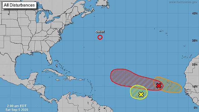
THE TROPICS: As of 1 a.m., A tropical wave and area of low pressure just west of the Cabo Verde Islands are producing a large area of disorganized showers and thunderstorms. Gradual development of this system is expected as it moves westward to west-northwestward, and a tropical depression is likely to form late this weekend or early next week when the system reaches the central tropical Atlantic. Formation chance through five days is high, 80%.
Another tropical wave is forecast to move off the west coast of Africa on Sunday. Gradual development of this system is expected, and a tropical depression could form by the middle of next week while it moves generally westward over the far eastern tropical Atlantic. Formation chance through five days is medium, 60%.
A nearly stationary and poorly defined area of low pressure is over the east-central tropical Atlantic, about midway between the west coast of Africa and the Windward Islands. This system continues to produce disorganized showers and thunderstorms, and development will likely be hindered by the interaction with a large tropical wave just west of the Cabo Verde Islands. Formation chance through five days is low, 20%.
And, finally, we have Tropical Depression Omar around 515 miles northeast of Bermuda and moving north-northeast at 7 mph. This general direction of motion with an increase in forward speed can be expected over the next couple of days. Maximum sustained winds remain near 35 mph with higher gusts. Omar is forecast to degenerate into a remnant low tonight or early Sunday and to dissipate by late Sunday or early Monday.
For more weather news and information from James Spann, Scott Martin and other members of the James Spann team, visit AlabamaWx.


