James Spann: Occasional showers for Alabama Saturday; eyes on the Gulf
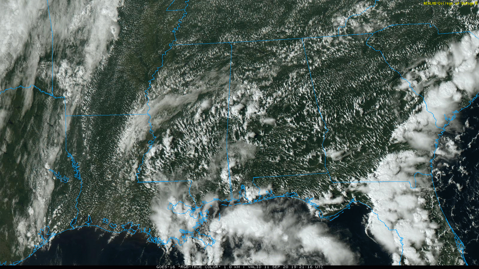
RADAR CHECK: A number of scattered showers are in progress across central Alabama this afternoon, moving westward in the tropical easterly flow over the state. A few thunderstorms are involved, but nothing severe. Away from the showers the sky is partly sunny with temperatures mostly between 87 and 90 degrees. Showers will fade away tonight as the air cools and becomes more stable.
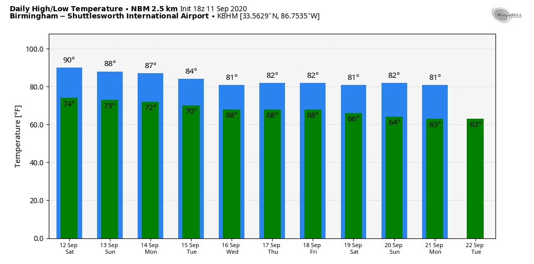
THE ALABAMA WEEKEND: Saturday will be occasionally cloudy, with a few passing showers and possibly a thunderstorm. Most (but not necessarily all) of the showers come from noon to 8 p.m., and while we don’t expect any severe storms the rain will be briefly heavy as a shower passes through due to the tropical nature of the air mass over Alabama. It certainly won’t be a washout, but be ready for an occasional shower.
It’s impossible to give start/stop times of the rain, since the activity will be scattered. Total rain amounts for the day should be one-quarter to one-half inch. Temps won’t be as hot as today; afternoon temperatures will range from 84 to 88. It will be very humid.
On Sunday, scattered showers and storms remain possible with a mix of sun and clouds and a high again in the mid 80s.
NEXT WEEK: The weather early in the week all depends on the tropical system in the northern Gulf of Mexico. Rain could be fairly widespread either Monday or Tuesday, depending on the size and intensity of the tropical feature (more on this below). The heaviest rain will be closer to the Gulf Coast, and highs will be in the mid 80s. Showers become fewer in number over the latter half of the week. Temperatures will show a downward trend with highs in the low to mid 80s; lows will be in the 60s.
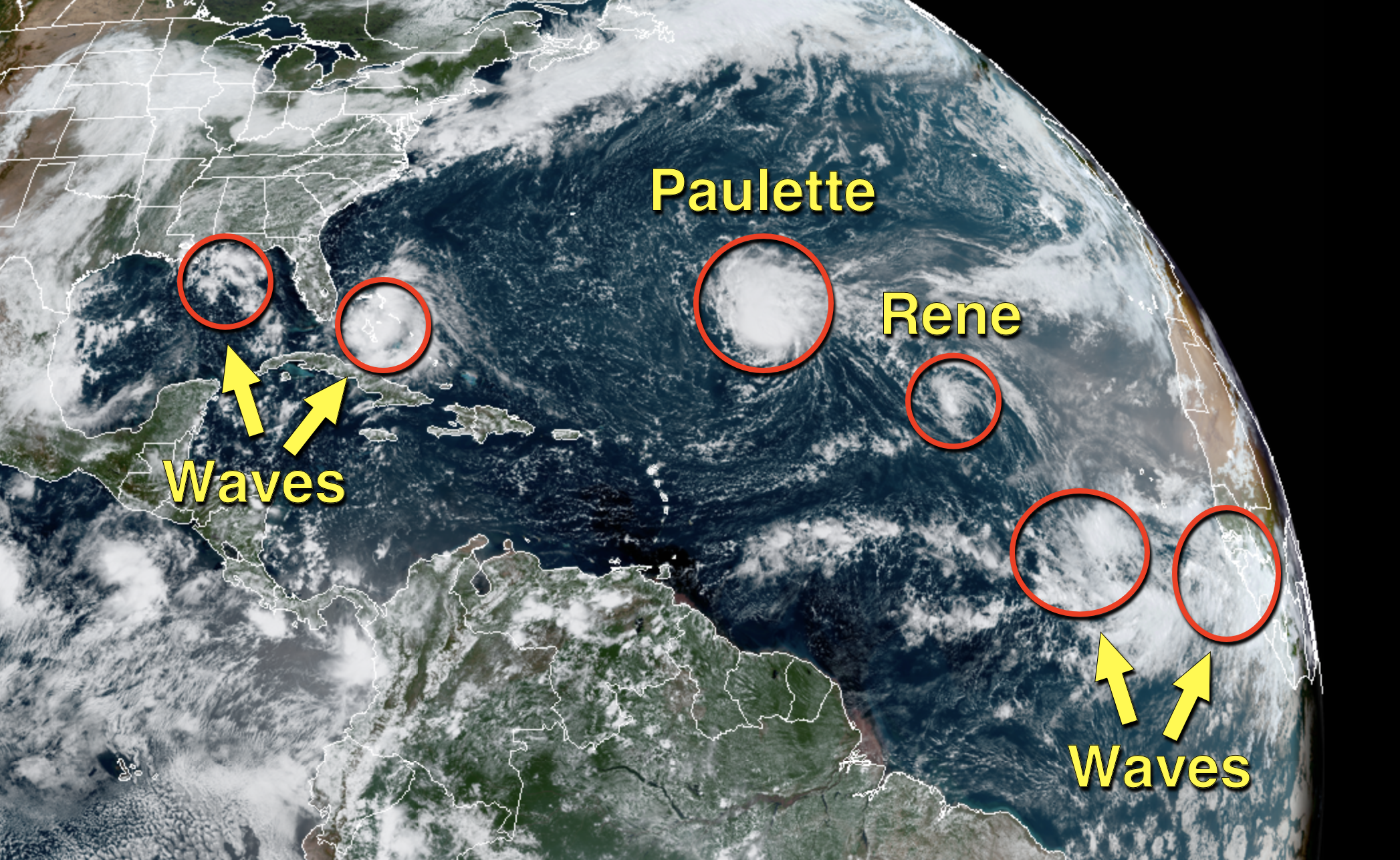
TROPICS: It’s another very busy afternoon across the Atlantic basin, with two tropical storms and four tropical waves.
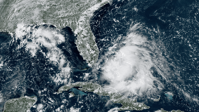
GULF OF MEXICO: There is a weak wave in the northern Gulf of Mexico; this is moving west-southwest with little chance of development. The system to watch is Invest 96L, approaching the southern tip of Florida. The National Hurricane Center is now giving this a high probability of becoming a tropical depression or storm once it gets into the eastern Gulf of Mexico Sunday. It will move in the direction of the Alabama Gulf Coast Monday and Monday night.
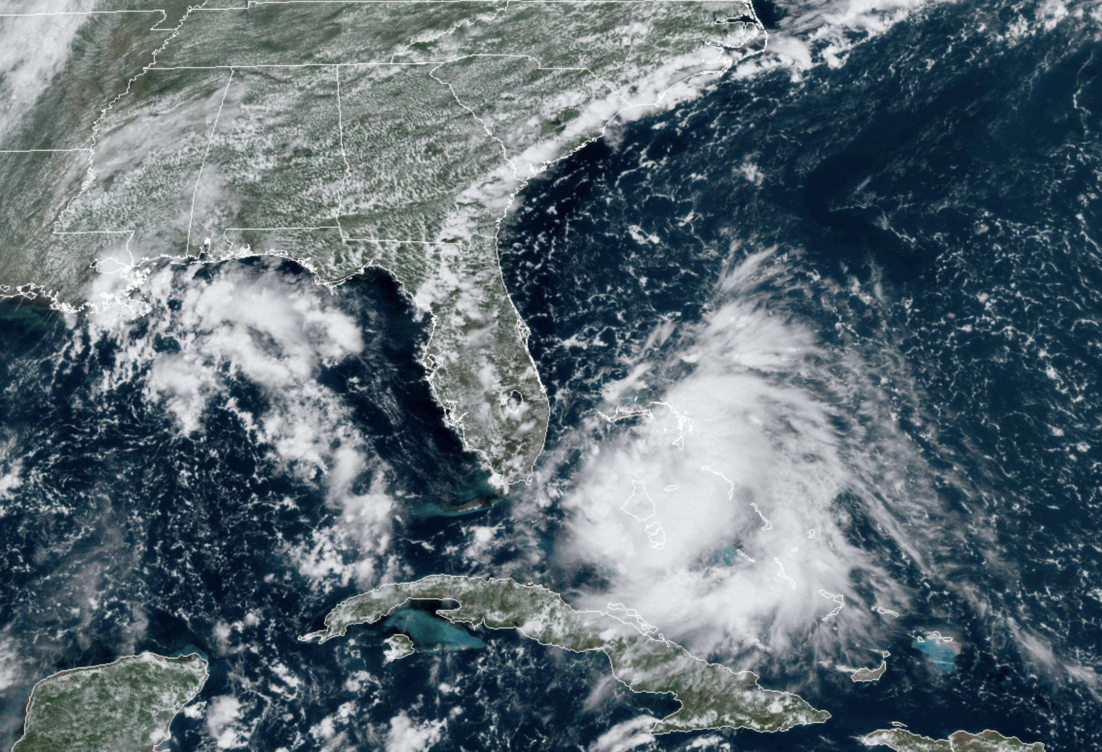
No doubt this feature will bring enhanced rain coverage to the Gulf Coast Sunday and Monday, along with potential for dangerous rip currents. If you are headed to the coast from Gulf Shores over to Panama City Beach, expect red or double red flags Saturday through early next week.
Until the system gets better organized, it is impossible to forecast the impact for any specific point on the Gulf Coast. However, we are seeing some intensity guidance suggesting 96L could become a Category 1 hurricane before landfall, so everyone needs to pay close attention to forecast updates over the weekend. Most likely, heavy rain and rip currents will be the primary impact, but we can’t rule out some storm surge issues if the system intensifies quickly. Weather on the Gulf Coast will improve after Monday night; the weather looks routine for the rest of the week with the usual mix of sun and scattered storms.
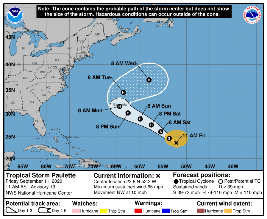
ELSEWHERE: Paulette is a tropical storm with winds of 65 mph; it is expected to be a Category 1 hurricane as it passes very close to Bermuda Monday. Then it turns sharply to the east-northeast out to sea with no impact on the U.S.
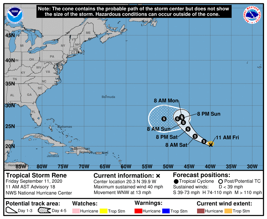
Tropical Storm Rene, which is east of Paulette in the open Atlantic, is a weak tropical storm that will linger far from land over the next five days.
The two tropical waves in the far eastern Atlantic both have a good chance of becoming tropical depressions or storms over the next five days; it remains to be seen whether they will affect the U.S. or any land.
The next names for tropical storms are Sally, Teddy, Vicky and Wilfred. Then we go to the Greek Alphabet.
ON THIS DATE IN 2001: Hurricane Erin was off the coast of New Jersey and New York. A cold front kept Hurricane Erin from drawing closer to the United States, which likely would have affected both weather and air travel in New York and Boston as airlines prepared for a potential strike from a formidable hurricane.
Adverse weather that morning would have been the butterfly effect in action. One small change in the starting conditions could have had a dramatic impact on the end result. A simple, lingering batch of rain or clouds, or even the effects of Hurricane Erin in New York City and Boston on Sept. 11, 2001, could have changed history and the world as we know it.
BEACH FORECAST: Click here to see the AlabamaWx Beach Forecast Center page.
WEATHER BRAINS: You can listen to our weekly 90-minute show anytime on your favorite podcast app. This is the show all about weather featuring many familiar voices, including the meteorologists at ABC 33/40.
CONNECT: You can find me on the major social networks:
Facebook
Twitter
Instagram
Pinterest
Snapchat: spannwx
For more weather news and information from James Spann and his team, visit AlabamaWx.


