Scott Martin: Alabama weather mainly dry, mild through midweek
THE ALABAMA WEEKEND: Today will feature a good bit of clouds and only a little bit of sunshine throughout the day as a southwesterly flow brings those clouds up from Tropical Storm Beta. We’ll stay dry across much of Alabama, with only a very small chance of an isolated shower south of I-20. Highs will be in the mid to upper 70s.
Cloud cover will stick around through Sunday, but we’ll lose that small chance of showers as all of Alabama will be dry and mild. Highs will be in the upper 70s to right at 80 degrees.
NEXT WEEK: A reinforcing shot of cooler, drier air will move into Alabama on Monday as high pressure sets up to our north-northeast, but we won’t lose the clouds. Highs will be in the lower to mid-70s.
Tuesday will be the same story. Skies will be mostly cloudy with very little sunshine. Highs on both days will be in the lower to mid-70s.
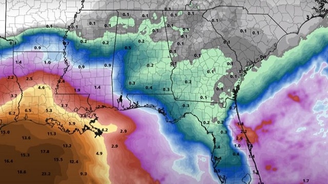
At this point, we look to stay dry throughout much of Wednesday, but tropical moisture from Beta will be moving into the southwestern and southern parts of the state during the evening and spreading northward overnight. Areas north of I-20 look to stay dry, with rain possible south of the interstate. Highs will be in the upper 70s to right around 80 degrees.
Rain doesn’t look like it will make it up north past I-20 on Thursday, with rain being likely for the southern half of the state. Even though it doesn’t show rain for the northern half, I can’t help but put a chance in the forecast. No matter what, it will be a cloudy, gray day. Highs will be in the upper 70s to the lower 80s.
Much of Alabama will remain dry on Friday, but a stray isolated shower or two may be possible. The good news is we’ll see a decent bit of sunshine. Afternoon highs will be warmer, in the lower to mid-80s.
TROPICS: It is still very busy in the tropics.
Beta: Storm surge and hurricane watches have been issued for much of the Texas coast, while a Tropical Storm Watch is issued as far east as Morgan City, Louisiana, as Tropical Storm Beta will be moving just offshore along the coastline. The center was about 305 miles east of the mouth of the Rio Grande and was moving north-northeast at 12 mph. A slow westward motion is expected to begin late today, with a slow northwestward motion forecast to begin late Sunday and continue through late Monday. On the forecast track, the center of Beta will slowly approach the Texas coast into early next week. Maximum winds were at 60 mph with higher gusts and Beta is expected to strengthen into a hurricane by Sunday.
Storm surge could reach 2-4 feet along the Texas coast as far east as Morgan City. Rough surf is expected along the Texas and Louisiana coasts, with larger waves reaching as far away as the Alabama Gulf Coast and western Florida Panhandle. Life-threatening rip currents can be expected along much of the northern and western Gulf Coast through at least Friday.
Teddy: Category 3 Hurricane Teddy continues on a path that will take it very close to the island of Bermuda, which is still recovering from Paulette moving over within the past week. Winds were at 130 mph and movement was to the northwest at 13 mph. The eye was about 730 miles southeast of Bermuda. This general motion is expected to continue for a day or so, followed by a turn north late this weekend. On the forecast track, Teddy will approach Bermuda late Sunday or early Monday. Some fluctuations in intensity are likely through today, with a weakening trend forecast to begin Sunday. A Tropical Storm Watch has been issued for all of Bermuda as tropical storm conditions will start to affect the island Sunday. Teddy will become extratropical by Tuesday morning and may move onshore over Nova Scotia Tuesday evening, still at hurricane strength.
Wilfred: The center of poorly organized Wilfred was about 830 miles west-southwest of the Cabo Verde Islands, moving west-northwest at 18 mph. Winds were at 40 mph and some slight strengthening is possible today before weakening likely begins by Sunday. No change in direction is expected over the next few days, and Wilfred is no threat to land.
Post-Tropical Cyclone Paulette is near the western Azores. The cyclone is forecast to move southward for the next couple of days and then stall over marginally warm waters a few hundred miles south of the Azores by the end of the weekend. The cyclone could redevelop tropical characteristics late this weekend or early next week while it moves little.
Another tropical wave is forecast to move off the west coast of Africa early today. Some slow development of the system will be possible while it moves generally west-northwestward over the far eastern Atlantic.
ON THIS DATE IN 1947: The eye of a hurricane passed directly over New Orleans, and the barometric pressure dipped to 28.61 inches. The hurricane killed 51 people and caused $110 million damage. It had produced wind gusts to 155 mph while making landfall over Fort Lauderdale, Florida, two days earlier.
BEACH FORECAST CENTER: Get the latest weather and rip current forecasts for the beaches from Dauphin Island to Panama City Beach, Florida, on our Beach Forecast Center page. There, you can select the forecast of the region you are interested in.
For more weather news and information from James Spann, Scott Martin and other members of the James Spann team, visit AlabamaWx.


