James Spann: Nice warm-up for Alabama today
James Spann forecasts a dry Friday, sometimes wet weekend for Alabama from Alabama NewsCenter on Vimeo.
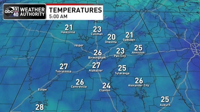
COLD START: Here are temperatures across Alabama just before daybreak this morning:
- Black Creek — 20
- Oneonta — 20
- Gadsden — 21
- Haleyville — 21
- Cullman — 22
- Decatur — 22
- Weaver — 22
- Pell City — 23
- Hueytown — 24
- Heflin — 24
- Good Hope — 24
- Remlap — 24
- Anniston — 25
- Bessemer — 25
- Huntsville — 25
- Demopolis — 26
- Tuscaloosa — 27
- Montgomery — 28
- Mobile — 30
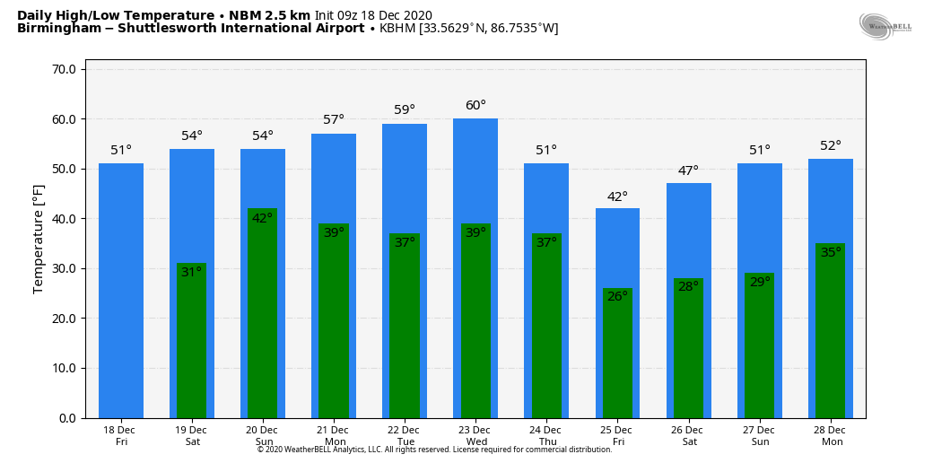
Expect a sunny sky today with a nice warm-up; we reach the 51- to 55-degree range this afternoon. Tonight will be clear and cold again; we drop into the 27- to 32-degree range early Saturday morning.
THE ALABAMA WEEKEND: Clouds increase Saturday with a high in the mid 50s. We expect periods of rain Saturday night into Sunday morning as the next upper trough moves through; rain amounts should be generally one-half inch or less, and there is no risk of severe storms (probably no thunder). The best chance of showers by Sunday afternoon will shift into the southern half of the state; the high Sunday will be in the mid to upper 50s.
CHRISTMAS WEEK: Monday and Tuesday will be dry with a good supply of sunshine both days; highs will be somewhere between 58 and 62. Clouds increase Wednesday, and a cold front will bring showers to the state Wednesday night into Thursday morning. Much colder air will roll into Alabama during the day Thursday following the frontal passage; there is a brief window when a snowflake or two is possible over the northern third of the state Thursday morning, but the air will dry out quickly and meaningful snow is not expected. Christmas Day will be cold and dry with a sunny sky; we begin the day well down in the 20s, maybe even the upper teens for a few places. The high will be between 37 and 44 degrees.
ON THIS DATE IN 1944: Typhoon Cobra, also known as the Typhoon of 1944 or Halsey’s Typhoon (after Admiral William “Bull” Halsey), was the United States Navy designation for a tropical cyclone that struck Task Force 38 during World War II in the Pacific. The typhoon was first observed on Dec. 17 as it surprised a fleet of ships in the open waters of the western Pacific Ocean. Sustained winds associated with the storm were up to 100 mph with gusts to 140 mph. On Dec. 18, the small but violent typhoon hit the Task Force while many of the ships were attempting to refuel. Because of the extreme seas and winds, three destroyers capsized and went down with practically all hands, while a cruiser, five aircraft carriers and three destroyers sustained serious damage. Approximately 790 officers and men were lost or killed, with another 80 injured.
BEACH FORECAST: Click here to see the AlabamaWx Beach Forecast Center page.
WEATHER BRAINS: You can listen to our weekly 90-minute show any time on your favorite podcast app. This is the show all about weather featuring many familiar voices, including the meteorologists at ABC 33/40.
CONNECT: You can find me on the major social networks:
For more weather news and information from James Spann and his team, visit AlabamaWx.


