Scott Martin: Alabama has potential for strong to severe New Year’s storms
STORMY NEW YEAR’S: New Year’s Eve will start off dry, but scattered showers will begin to build throughout the late morning and into the afternoon. For now, the heavier rain and thunderstorms will begin to move into Alabama from the southwest during the evening and late night. At that time, a few storms may become strong to severe.
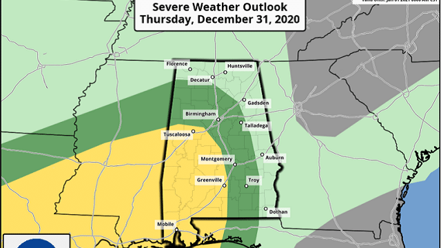
The latest update from the the Storm Prediction Center has the southwestern quarter of Alabama in a level 2 slight risk for severe storms, including locations west of a line from Reform to Brookwood to Billingsley to Fort Deposit. A level 1 marginal risk includes locations west of a line from Russellville to Falkville to Steele to Tuskegee to Clio.
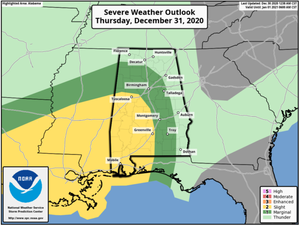
For now, the timing for potential severe storms looks to start around 9 p.m. Thursday and persist until at least 8 a.m. Friday morning. Damaging winds up to 60 mph and a few tornadoes will be possible in the risk areas. Pressure-gradient winds may gust as high as 35-40 mph, so a Wind Advisory may be issued before the storms get fired up on Thursday.
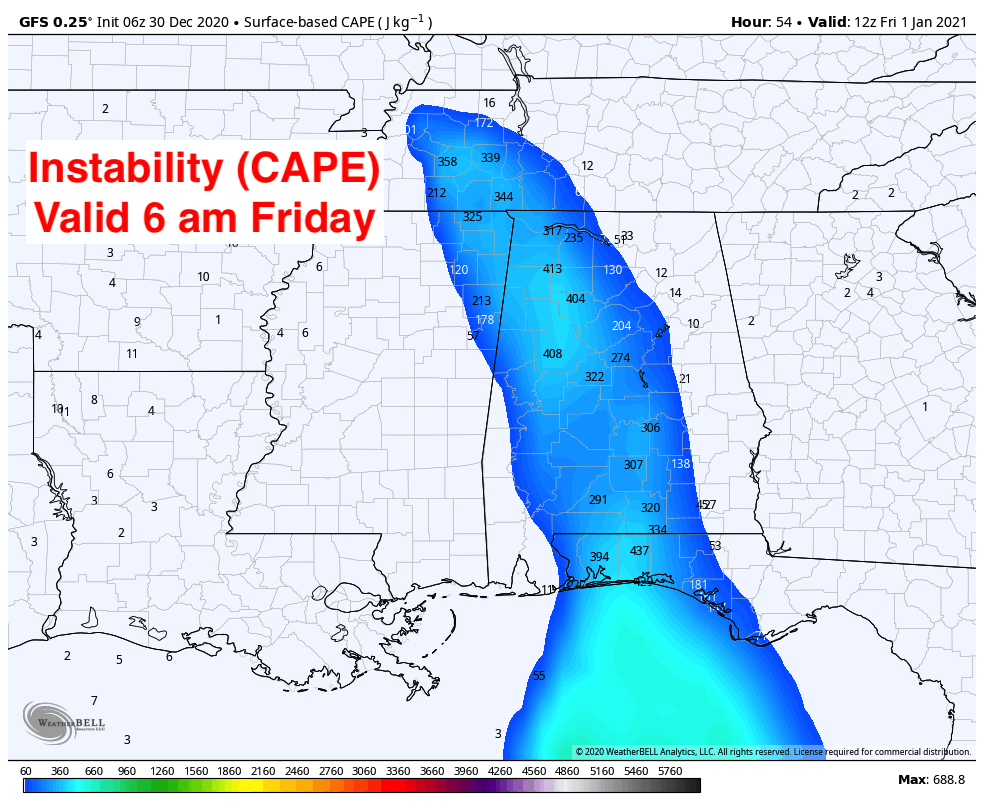
This appears to be a low instability/high shear event, but with these winter systems it does not take that much instability to get severe storms started. There will be plenty of wind shear in place, and models are showing a good bit of helicity, so there will be the potential for some rotating updrafts.
Locations in western Alabama will start to dry out before midday Friday as the activity continues to march eastward, eventually leaving the state by Friday evening. The SPC has southeastern Alabama in a marginal risk of severe weather on Friday. Highs will be in the lower 60s to the lower 70s Thursday and into the upper 60s to the lower 70s Friday.
THE ALABAMA WEEKEND: Saturday will be much cooler with a mix of sun and clouds. Afternoon highs will be in the lower 50s to the lower 60s. Sunday will be even cooler. Skies will be mainly sunny with highs in the upper 40s to the upper 50s.
THE FIRST WORK WEEK OF 2021: We start a warming trend on Monday. Skies will be mainly sunny with highs reaching the lower 50s to right around 60 degrees from northwest to southeast. On Tuesday we’ll have a few more clouds, but there will be more sun than clouds. Highs will be in the mid-50s to the lower 60s.
ON THIS DATE IN 1983: Record cold temperatures hit the Gulf States; the temperature at Tupelo, Mississippi, was 7 degrees. This was the coldest week on record at Baton Rouge, Louisiana, and the coldest December on record at Corpus Christi, Texas. Some areas broke their old temperature records by as much as 12 degrees.
BEACH FORECAST CENTER: Get the latest weather and rip current forecasts for the beaches from Dauphin Island to Panama City Beach, Florida, on our Beach Forecast Center page. There, you can select the forecast of the region you are interested in.
For more weather news and information from James Spann, Scott Martin and other members of the James Spann team, visit AlabamaWx.


