James Spann: Brighter, drier day for Alabama Wednesday
RADAR CHECK: Large patches of light rain continue across much of Alabama this afternoon; some sleet was even in the mix over the northwest part of the state, where the air is colder. Temperatures are mostly in the 40s; the average high for Birmingham on March 2 is 63. Rain will end from west to east tonight, but clouds will linger.
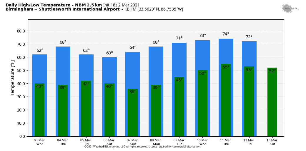
WARMER DAYS AHEAD: The sky becomes mostly sunny Wednesday as a nice punch of dry air arrives; the high will be between 61 and 65 degrees. Thursday will be another sunny day with a high between 67 and 71. Some clouds will creep into the state Friday, but the day will stay dry with a high in the upper 60s. A disturbance will bring the chance of some sprinkles to the state Friday night, but moisture will be very limited and rain amounts, if any, will be very light and spotty.
THE ALABAMA WEEKEND: A few sprinkles are possible Saturday morning; otherwise the sky becomes partly sunny with a high in the low 60s. Sunday will feature sunshine in full supply with a high in the mid 60s. Sunday morning will be chilly, with a low in the mid 30s; it is possible colder pockets could see a light freeze.
NEXT WEEK: The weather continues to look quiet with an upper ridge building over the eastern third of the nation. A few isolated showers could show up at some point late in the week, but for now we see no high-impact weather events for Alabama for the next seven to 10 days. Highs will be in the 60s Monday and Tuesday, with 70s over the latter half of the week.
ON THIS DATE IN 2012: Twelve tornadoes touched down in Alabama, including one EF-2 in Tallapoosa and Chambers counties that killed one person. This large multiple-vortex tornado crossed Lake Martin near the beginning of its path before passing near Jackson’s Gap, Eagle Creek and Trammel Crossroads. Several homes sustained significant damage and multiple mobile homes were destroyed. One mobile home frame was wrapped completely around a tree trunk. Thousands of trees were snapped and uprooted along the path.
In the Tennessee Valley, an EF-3 tornado tore through parts of Limestone and Madison counties. This tornado first moved through multiple subdivisions near Athens, with roofs torn off homes, windows and garage doors blown out, exterior walls damaged and garages collapsed. The tornado then caused major roof and exterior wall damage to homes in and around Harvest. Homes at the north edge of Meridianville had their roofs torn off, a metal shed was severely damaged, a concrete power pole was snapped and buildings at Meridianville Middle School sustained roof damage. The most intense damage occurred near Hazel Green, where several homes had roofs torn off and walls collapsed, and three were reduced to rubble.
BEACH FORECAST: Click here to see the AlabamaWx Beach Forecast Center page.
WEATHER BRAINS: You can listen to our weekly 90-minute show any time on your favorite podcast app. This is the show all about weather featuring many familiar voices, including the meteorologists at ABC 33/40.
CONNECT: You can find me on the major social networks:
For more weather news and information from James Spann and his team, visit AlabamaWx.