James Spann: Major severe weather threat for Alabama Thursday afternoon, night
James Spann has the midweek forecast for Alabama from Alabama NewsCenter on Vimeo.
QUIET TODAY: A surface front has become nearly stationary just west of Alabama. Rain continues over the southern part of the state early this morning. Today will be mild with more clouds than sun and, while a few scattered showers are possible, much of the day will be dry. Temperatures reach the 74- to 78-degree range this afternoon.
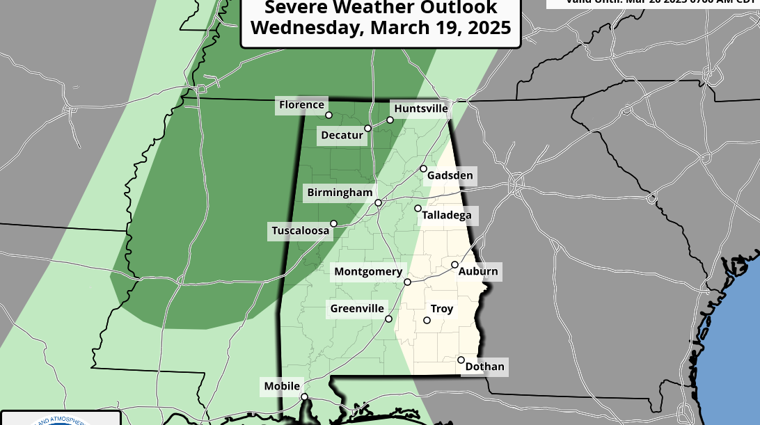
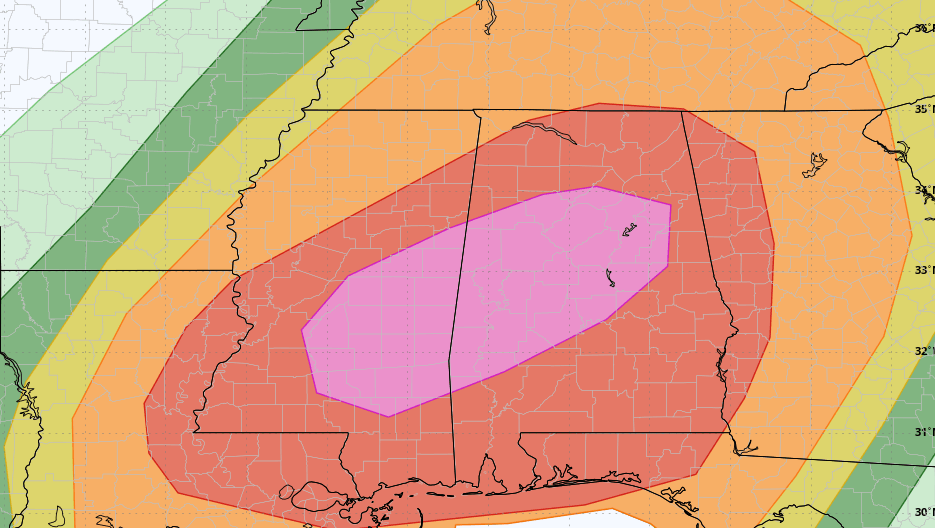
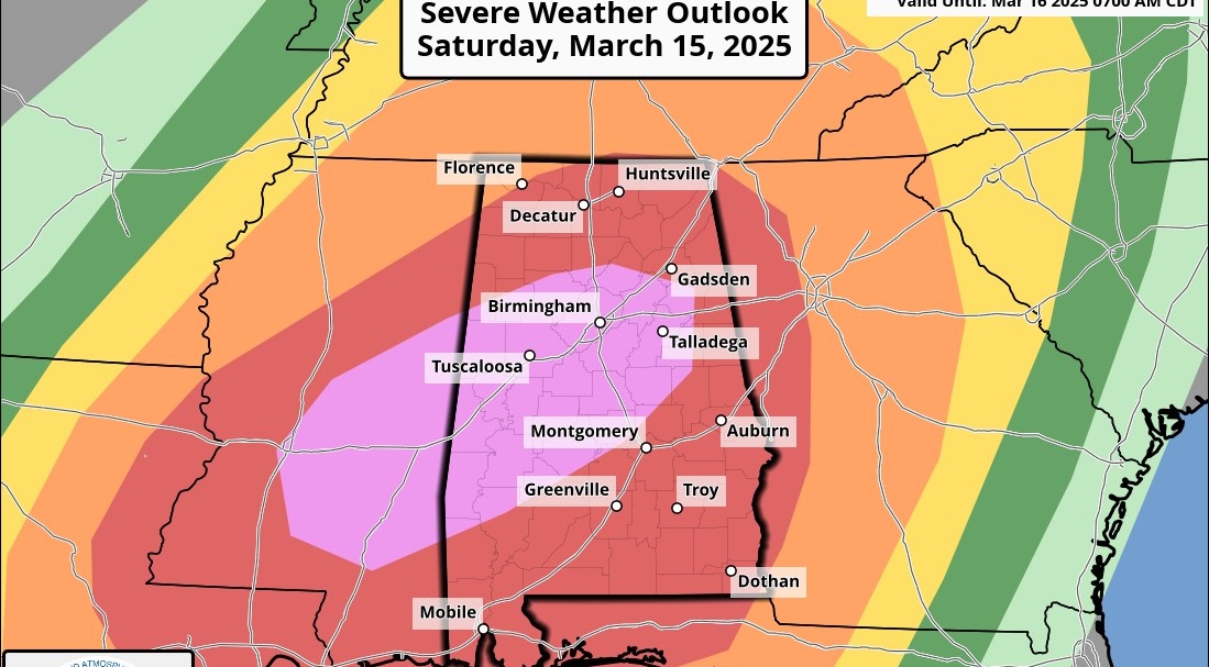
ANOTHER MAJOR SEVERE WEATHER THREAT: For the second week in a row we have a potentially dangerous severe weather setup for Alabama. This one comes Thursday afternoon and night. The Storm Prediction Center has defined a moderate risk (level 4 of 5) for that part of Alabama west of a line from Huntsville to Birmingham to Demopolis. An enhanced risk (level 3 of 5) runs as far east as Heflin, Rockford, Selma and Thomasville. The slight risk (level 2 of 5) extends to Opelika, Troy and Andalusia. A marginal risk (level 1 of 5) has been defined for the southeast corner of the state.
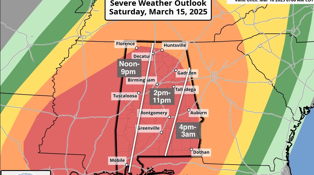
TIMING: Showers and storms are possible, if not likely, across parts of Alabama Thursday morning, but they will most likely remain below severe limits. The window for severe thunderstorms over northwest Alabama will run from 1 until 9 p.m.; for places like Birmingham, Tuscaloosa, Anniston and Gadsden the window is from 3 until 11 p.m., and for Montgomery and points south and east the threat will come from 5 p.m. until 1 a.m.
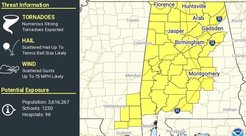
THREATS: Thunderstorms will be capable of producing large hail, damaging winds and tornadoes. A few violent, long-track tornadoes are possible, especially in the moderate-risk area along and north of I-59.
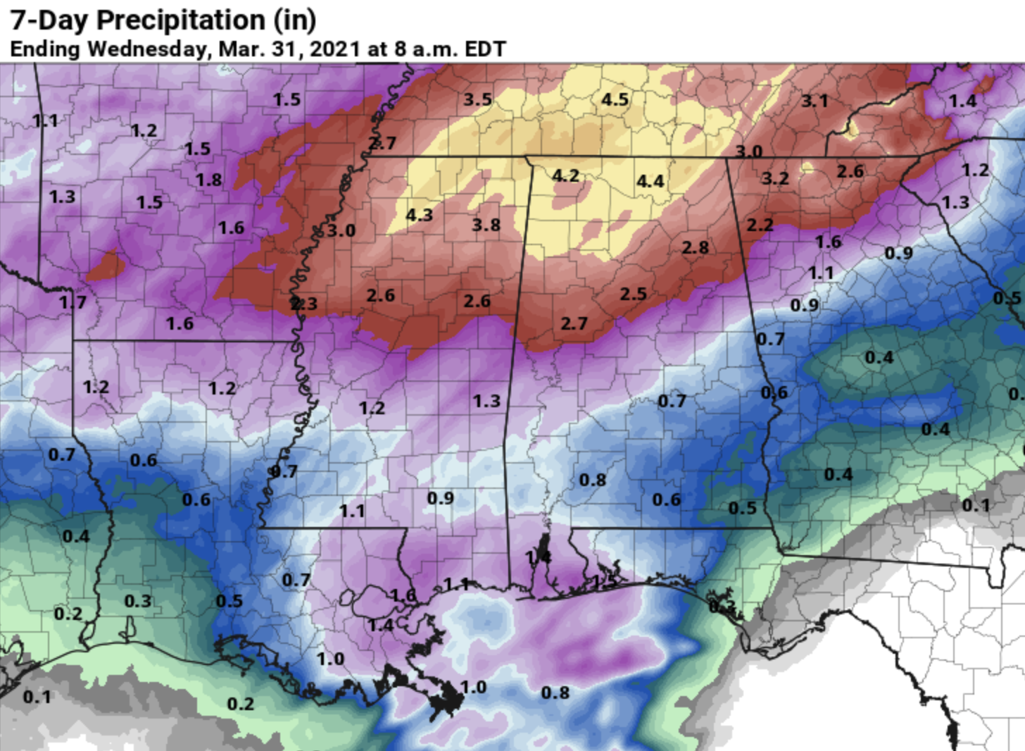
RAIN: The heaviest rain with this event will come over the Tennessee Valley of north Alabama, where some places could see more than 2 inches. Some flooding is possible. Amounts elsewhere will be around 1 inch.
GET READY: Alabamians did a remarkable job of being ready for last week’s severe weather event on March 17. We had 25 tornadoes in the state, but not a single injury despite major damage. We need the same level of preparedness for Thursday:
- Have two ways of hearing warnings. Never, ever, ever rely on a siren. Every Alabama home and business needs a NOAA Weather Radio (the most popular model is the Midland WR-120, which is sold in most big-box retailers). The other way is your phone. Be sure emergency alerts are enabled (look under settings and notifications) and install the free ABC 33/40 Weather app.
- Know the safe place in your house, and in that safe place have helmets for everyone. Bicycle helmets and batting helmets work well. We also recommend portable air horns and hard-soled shoes for everyone.
- If you live in an apartment complex, you can’t be above the first level. Shelter with a friend on the ground level or ask management if they can open the clubhouse during a tornado warning.
- If you live in a mobile home, you can’t stay there during a tornado warning. Know the location of the nearest shelter or business that is open 24/7. Know how to get there quickly.
BE A HERO: You can help us. Tell your friends, neighbors and relatives about the threat and what they need to do to get ready. If they fall in a tornado warning polygon, call them or text them to let them know about the threat. You are our most valuable resource in spreading the word.
Many of you have anxiety about severe weather, especially those who have gone through tornadoes or other kinds of violent weather. Have comfort knowing that even on the biggest severe weather days, odds of any one home being hit by a tornado are very low. But you have to pay attention and be prepared. We will get through the day together.
FRIDAY AND THE WEEKEND: The sky becomes partly sunny Friday as a slot of dry air works into the state. Showers and maybe a few thunderstorms return Friday night as the front over south Alabama begins to lift northward as a warm front. Some of those storms could produce small hail and gusty winds.
Saturday will be warm and dry for the southern half of the state, but showers remain possible for north Alabama. Temperatures will likely reach the low 80s Saturday afternoon. Sunday will be mostly cloudy with some rain at times as the front gets a push southward. The high Sunday will be in the 70s.
NEXT WEEK: Showers could linger into Monday over south Alabama. Tuesday looks rain-free. A cold front will bring a band of showers late Wednesday or Wednesday night, but for now severe storms are not expected.
ON THIS DATE IN 1975: “The Governor’s Tornado” hop-scotched a 13-mile path across the western part of Atlanta during the early morning, causing considerable damage to the governor’s mansion. Hundreds of expensive homes, businesses and apartment complexes were damaged. Total losses were estimated at $56 million. Three people lost their lives, and the F-3 tornado injured another 152.
BEACH FORECAST: Click here to see the AlabamaWx Beach Forecast Center page.
WEATHER BRAINS: You can listen to our weekly 90-minute show any time on your favorite podcast app. This is the show all about weather featuring many familiar voices, including the meteorologists at ABC 33/40.
CONNECT: You can find me on the major social networks:
For more weather news and information from James Spann and his team, visit AlabamaWx.