James Spann: Some sun, more showers and storms ahead for Alabama
James Spann has the midweek forecast for Alabama from Alabama NewsCenter on Vimeo.
RADAR CHECK: Rain and thunderstorms were over the northwest counties of Alabama around sunrise this morning. Some spots in this region have received more than 1 inch of rain since midnight. For the rest of the state, the sky is mostly cloudy with temperatures generally in the low 70s. Alabama’s weather won’t change much today; we have “air you can wear” with high precipitable water values, so a number of showers and storms will form later today. These will be efficient rain producers, but organized severe weather or flash flooding for now is not expected. The sun will be out at times, and the high today will be in the low to mid 80s for most places.
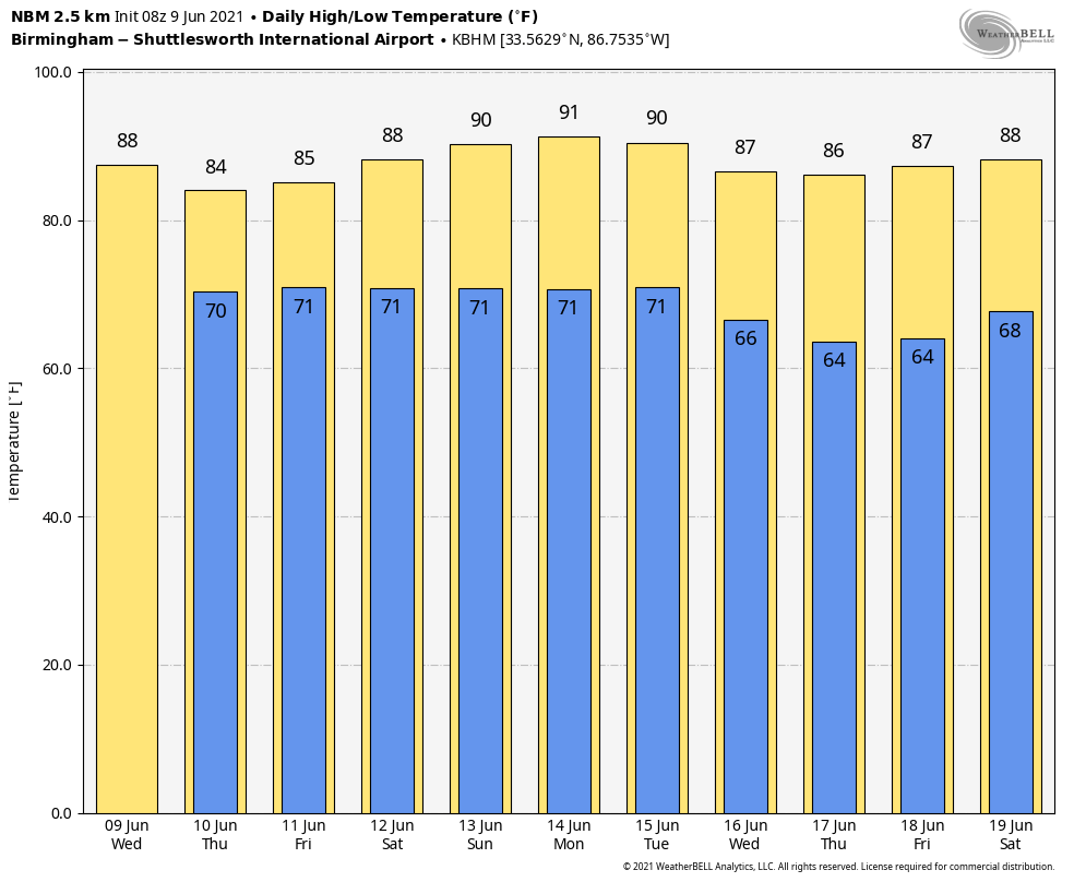
THURSDAY THROUGH THE WEEKEND: No big changes Thursday, Friday and Saturday. Look for mixed sun and clouds each day with scattered to numerous showers and thunderstorms, especially during the afternoons and evenings between 1 and 11 p.m. Highs will be in the mid 80s, a little below average for mid-June in Alabama. Showers will become fewer in number Sunday as the air will be a little drier. Some spots could hit 90 degrees Sunday afternoon with a partly sunny sky.
NEXT WEEK: The trend toward drier weather will continue next week. We do expect showers around each afternoon and evening, but they should be widely spaced. Otherwise, expect partly sunny days with highs between 86 and 91 degrees.
WEDNESDAY’S RAIN: Some of the heavier rain totals across Alabama Wednesday included 2.36 inches at Carbon Hill, 2.1 inches at Haleyville and 1 inch at Fayette.
TROPICS: The Atlantic basin is quiet this morning, but a broad trough of low pressure is expected to develop over the southwestern Caribbean Sea during the next couple of days. Some gradual development will be possible thereafter while the system moves slowly northwestward toward Central America. Regardless of development, this system could produce heavy rainfall across northern Colombia and portions of Central America from Honduras southward later this week and into the weekend.
Toward the latter half of next week, global models suggest a tropical low will form over the western Gulf of Mexico; it’s just something to watch for now as it is way too early to be specific.
ON THIS DATE IN 1966: Hurricane Alma made landfall over the eastern Florida panhandle, becoming the earliest hurricane to make landfall on the United States mainland.
BEACH FORECAST: Click here to see the AlabamaWx Beach Forecast Center page.
WEATHER BRAINS: You can listen to our weekly 90-minute show any time on your favorite podcast app. This is the show all about weather featuring many familiar voices, including the meteorologists at ABC 33/40.
CONNECT: You can find me on the major social networks:
For more weather news and information from James Spann and his team, visit AlabamaWx.


