James Spann: Dry Friday for most of Alabama, then tropical rain arrives Saturday
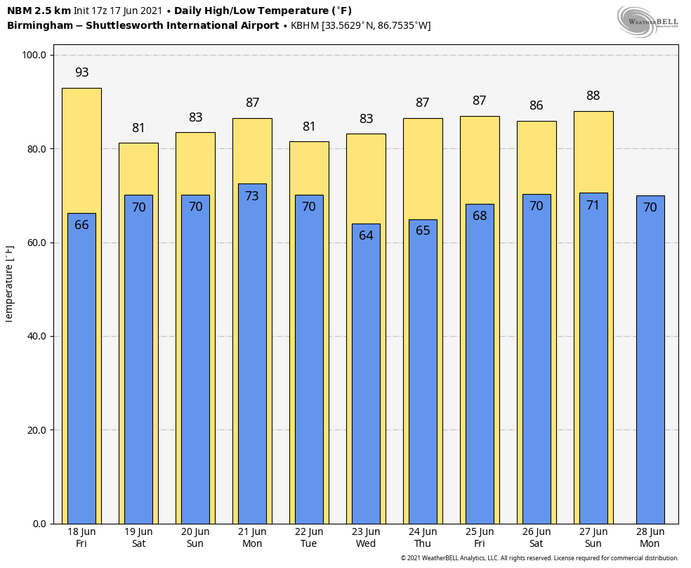
ANOTHER DRY JUNE DAY: The sky is mostly sunny across Alabama this afternoon with temperatures generally between 87 and 91 degrees. The sky will be mostly fair tonight with a low in the mid to upper 60s.
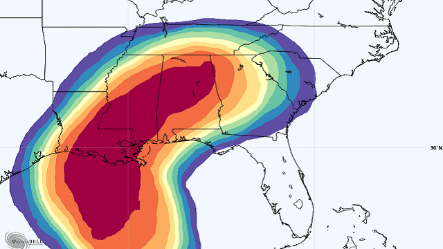
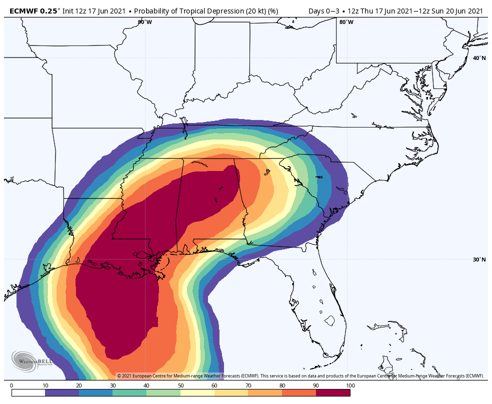
FRIDAY AND THE WEEKEND: A tropical depression expected to form tonight in the western Gulf of Mexico will spread rain into south Alabama Friday, but the rest of the state will be dry with a partly sunny sky and a high in the low 90s. Rain will continue over the southern half of the state Friday night.
On Saturday the rain shield will expand into the northern half of the state by late morning, and widespread rain is likely Saturday afternoon and Saturday night as the tropical low approaches. While the coverage of the rain will likely decrease Sunday, we still expect periods of rain and possibly a thunderstorm.
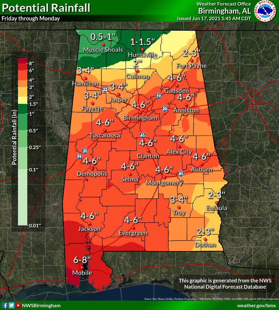
Rain could be heavy at times over the weekend, and a Flash Flood Watch is in effect for southwest Alabama. Rain amounts in the Flash Flood Watch area could exceed 6 inches by Sunday. Rain totals of 3-6 inches are likely across much of central Alabama, with around 1 inch for the Tennessee Valley of north Alabama.
A few brief, isolated tornadoes are possible across far south Alabama late Saturday, Saturday night and early Sunday. But for most of the state, rain and flooding are the main concerns. Many places will hold in the 70s Saturday because of clouds and rain; the high Sunday will be in the low 80s.
NEXT WEEK: Deep, tropical moisture will still be around early in the week, although the tropical low will be long gone. A cold front will be approaching Tuesday. We expect scattered to numerous showers and thunderstorms Monday and Tuesday, followed by much drier weather for the latter half of the week.
TROPICS: The developing tropical depression in the Gulf will move into Louisiana late Friday or Friday night, and the main impact for the coast will be heavy rain, coastal flooding and rip currents. A few isolated, brief tornadoes or waterspouts are also possible. The weather will begin to improve along the Gulf Coast Sunday, and the weather for much of next week looks fairly routine with the usual mix of sun and scattered storms. The rest of the Atlantic basin is quiet.
ON THIS DATE IN 1946: The third-deadliest tornado in Canadian history struck southwestern Ontario from Windsor to Tecumseh. Seventeen people were killed and hundreds injured. Damage was conservatively estimated at $1.5 million.
BEACH FORECAST: Click here to see the AlabamaWx Beach Forecast Center page.
WEATHER BRAINS: You can listen to our weekly 90-minute show any time on your favorite podcast app. This is the show all about weather featuring many familiar voices, including the meteorologists at ABC 33/40.
CONNECT: You can find me on the major social networks:
For more weather news and information from James Spann and his team, visit AlabamaWx.