James Spann: Scattered showers, storms for Alabama through Thursday
James Spann has the midweek forecast for Alabama from Alabama NewsCenter on Vimeo.
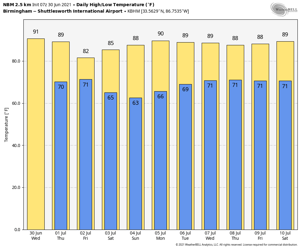
WARM, HUMID SUMMER DAYS: A blanket of moist, tropical air will cover Alabama for the rest of the week. Look for a mix of sun and clouds Wednesday and Thursday with the usual threat of random, scattered, mostly afternoon and evening showers and thunderstorms. The chance of any one spot getting wet is around 30% Wednesday and 40-50% Thursday. The high will be in the upper 80s Wednesday, followed by mid 80s Thursday, below average for this time of the year.
FRIDAY: A rare July cold front will approach from the north and bring a fairly wet day to the state. We expect a cloudy sky with periods of rain and a few thunderstorms; rain amounts of around 1 inch are likely (but, of course, your number may vary). Many places will hold in the 70s all day because of clouds and rain.
THE HOLIDAY WEEKEND: The front will push into south Alabama Friday night, and dry air will move into the northern half of the state for the holiday weekend. For north and central Alabama, we expect partly to mostly sunny days, lower humidity levels and cooler nights. Highs will be in the 80s and many spots will dip into the cool 50s early Sunday morning. Scattered showers and storms will remain possible over south Alabama Saturday and Sunday, especially south of U.S. 84. But, even there, the weekend won’t be a washout.
NEXT WEEK: Monday will remain dry for the northern half of the state; then moisture creeps northward and there will be some risk of scattered showers or storms daily Tuesday through Friday. It’s too early to know whether any tropical system will become a factor.
TROPICS: The National Hurricane Center is monitoring two tropical waves in the Atlantic. The lead wave, Invest 95L, is a couple of hundred miles east of the Lesser Antilles. Significant development of this system is unlikely while it moves quickly westward to west-northwestward at 20 to 25 mph, passing through the Lesser Antilles today and then across the eastern and central Caribbean Sea later this week. The chance of development over the next five days is only 10%.
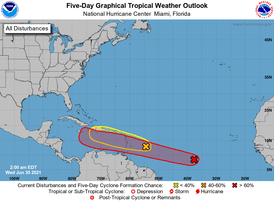
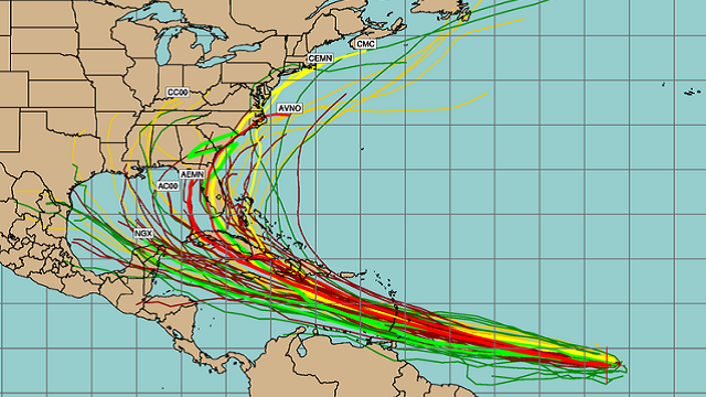
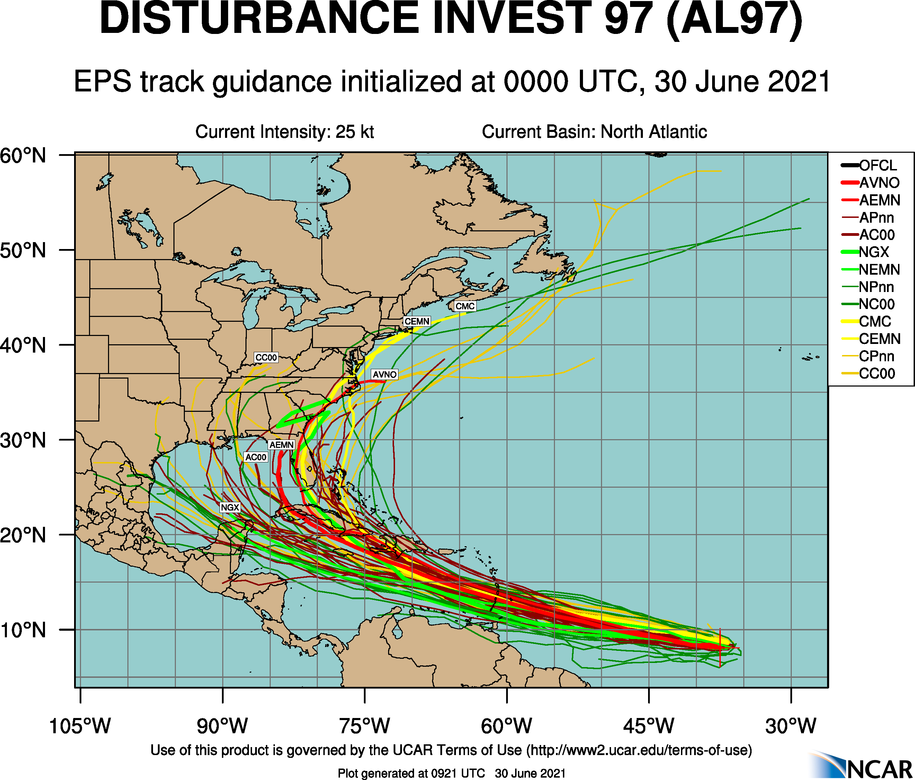
The focus is on the trailing wave in the Central Atlantic, Invest 97L. It is about midway between the west coast of Africa and the Windward Islands. This system is producing a large area of showers and thunderstorms that continues to show some signs of organization. Environmental conditions appear generally favorable for development, and a tropical depression is likely to form during the next few days while the system moves west-northwestward at about 20 mph. The chance of development over the next five days is now 70%.
It is too early to know whether this system will ultimately reach the Gulf of Mexico or turn northward before affecting the U.S. Nobody knows the ultimate destination or intensity now. Once the system develops and we get upper-air dropsonde data from hurricane hunters, confidence in the forecast track will increase.
ON THIS DATE IN 1912: An estimated F4 tornado ripped through Regina, Saskatchewan, Canada. The storm became the deadliest tornado in Canada’s history as it killed 28 people along a rare, 18.5-mile track from south to north.
BEACH FORECAST: Click here to see the AlabamaWx Beach Forecast Center page.
WEATHER BRAINS: You can listen to our weekly 90-minute show any time on your favorite podcast app. This is the show all about weather featuring many familiar voices, including the meteorologists at ABC 33/40.
CONNECT: You can find me on the major social networks:
For more weather news and information from James Spann and his team, visit AlabamaWx.


