James Spann: More humid day for Alabama, with scattered afternoon showers, storms
James Spann forecasts rising rain chances for Alabama from Alabama NewsCenter on Vimeo.
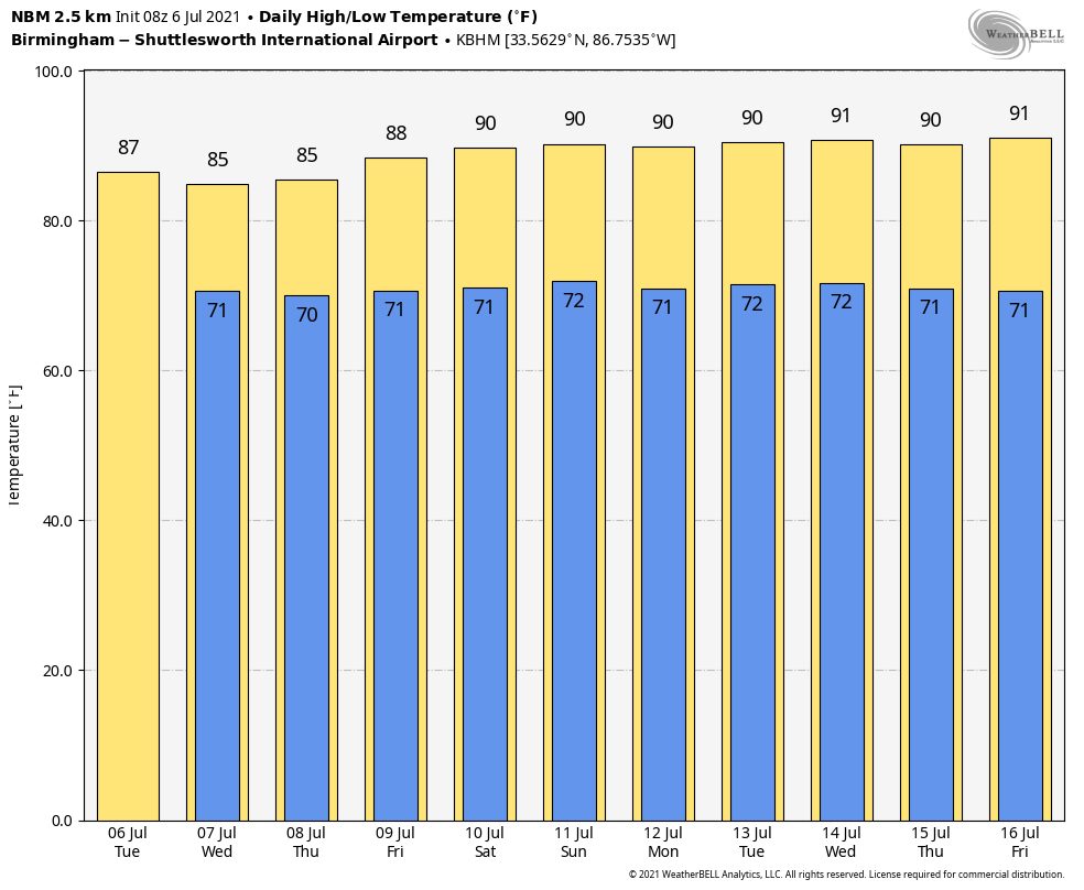
RISING HUMIDITY LEVELS: The weather will be more humid over the northern half of Alabama today, and we will bring a chance of scattered showers and thunderstorms statewide. A few showers are in progress near the Gulf Coast early this morning, but most of the showers today will come from about noon to midnight. Otherwise, expect a mix of sun and clouds with highs generally in the mid 80s. The average high for July 6 at Birmingham is 91.
REST OF THE WEEK: With deep moisture in place and an upper trough nearby, we expect scattered to numerous showers and thunderstorms Wednesday and Thursday. The sky will feature more clouds than sun, and highs will be only 78 to 83 degrees due to clouds and rain. On Friday the sky will be partly sunny with scattered showers and storms possible mostly during the afternoon and evening. The high Friday will be in the mid to upper 80s.
THE ALABAMA WEEKEND: For now it looks like we will have some classic summer weather, partly sunny Saturday and Sunday with the usual threat of scattered showers and thunderstorms mostly from about 1 until 11 p.m. The chance of any one spot getting wet both days will be 20-30% and the high will be between 87 and 91 degrees.
NEXT WEEK: Don’t expect much change as an upper high builds. Look for hot, humid days with an afternoon shower or storm in spots each day, just what you expect in July in Alabama. Highs each day will be close to 90 degrees.
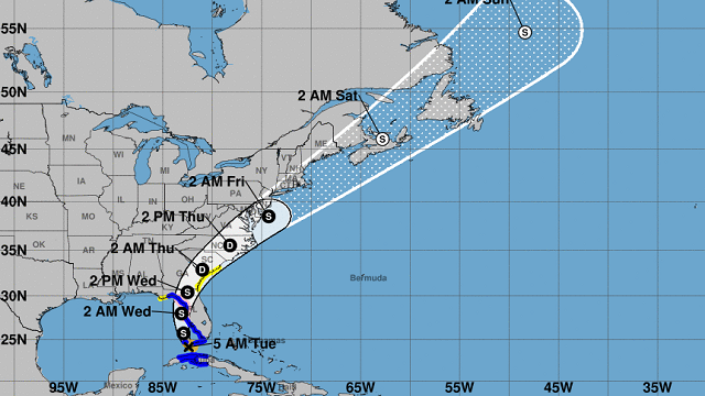
EYES ON ELSA: Tropical Storm Elsa is in the far southeast Gulf of Mexico early this morning with sustained winds of 60 mph. A Hurricane Watch has been issued for the west-central and Big Bend coast of Florida from Egmont Key to the Steinhatchee River, since there is a chance Elsa reaches minimal hurricane strength before landfall north of Tampa late tonight. Much of the west coast of the Florida Peninsula is expected to see wind, rain and surge impacts since that region will be on Elsa’s east side. A Tropical Storm Watch has also been issued for the Georgia coast and portions of the South Carolina coast as the system moves northeast.
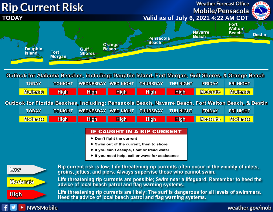
 A storm surge of 3-5 feet is forecast for parts of the Florida west coast, including Tampa Bay. Also, there is the threat of a few isolated tornadoes over the Florida Peninsula today. While the direct impact of Elsa will be east of the central Gulf Coast (Gulf Shores, Pensacola, Destin, Panama City Beach), we do note there is a high danger of rip currents Wednesday and Thursday.
On the positive side, the rest of the Atlantic basin is very quiet, and additional tropical storm formation is not expected this week.
ON THIS DATE IN 1893: A violent tornado killed 71 people on its 40-mile track across northwestern Iowa. Forty-nine people were killed around Pomeroy, where 80% of the buildings were destroyed, with most leveled to the ground.
ON THIS DATE IN 1928: A 7-inch hailstone weighing 1.5 pounds fell in Potter, Nebraska. With a circumference of 17 inches, this appeared to be the largest hailstone in the world at that time.
BEACH FORECAST: Click here to see the AlabamaWx Beach Forecast Center page.
WEATHER BRAINS: You can listen to our weekly 90-minute show any time on your favorite podcast app. This is the show all about weather featuring many familiar voices, including the meteorologists at ABC 33/40.
CONNECT: You can find me on the major social networks:
For more weather news and information from James Spann and his team, visit AlabamaWx.


