James Spann: Only isolated showers for Alabama through midweek
RADAR CHECK: Most of Alabama is rain-free this afternoon, but showers and a few storms are seen over the far southern part of the state, mainly south of U.S. 84. A few waterspouts were seen today off the Alabama Gulf Coast near Gulf Shores and Fort Morgan. The sky is partly sunny, and temperatures are mostly in the mid to upper 80s. The average high for Birmingham on Aug. 3 is 91.
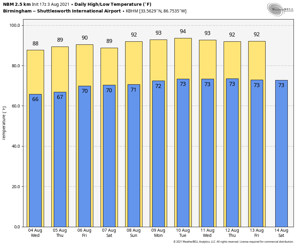
The weather won’t change much Wednesday and Thursday. Look for partly sunny days and just a few isolated showers and storms during the afternoon and evening hours. Expect highs between 86 and 89 degrees.
FRIDAY AND THE WEEKEND: Moisture levels rise a bit, and we will have the chance of scattered showers and thunderstorms each day with a mix of sun and clouds. The chance of any one spot getting wet is 25-35% Friday, rising to 45-55% over the weekend. Most of the showers and thunderstorms will come from 1 until 10 p.m. Highs will be generally between 87 and 90 degrees.
NEXT WEEK: An upper ridge begins to rebuild over the region during the first half of the week; showers and storms should be few with highs rising into the low 90s. Global models hint that coverage of showers and thunderstorms could increase late in the week.
TROPICS: No tropical storm formation is expected in the Gulf of Mexico or near the U.S. over the next five days. Out in the far eastern Atlantic, a small area of low pressure with some associated showers and thunderstorms is about 100 miles south of Praia in the Cabo Verde Islands. Significant development of this system is not expected during the next day or two due to unfavorable upper-level winds and marginally warm waters. The low is forecast to move northward or north-northwestward through Thursday before the system moves over cool waters, ending development chances.
A tropical wave is forecast to move off the west coast of Africa by late Thursday. This system has the potential for slow development over the far eastern Atlantic through the weekend while it moves westward at about 15 mph.
ON THIS DATE IN 1970: Hurricane Celia made landfall near Port Aransas as a major hurricane, Category 3 on the Saffir-Simpson scale with sustained winds of 130 mph. Celia was the costliest tropical cyclone in Texas history until Hurricane Alicia in 1983.
ONE YEAR AGO TODAY: Hurricane Isaias was a Category 1 hurricane that made landfall at Ocean Isle Beach, North Carolina, with maximum sustained winds near 85 mph.
BEACH FORECAST: Click here to see the AlabamaWx Beach Forecast Center page.
WEATHER BRAINS: You can listen to our weekly 90-minute show any time on your favorite podcast app. This is the show all about weather featuring many familiar voices, including the meteorologists at ABC 33/40.
CONNECT: You can find me on the major social networks:
For more weather news and information from James Spann and his team, visit AlabamaWx.