James Spann: Tropical rain continues in Alabama; isolated tornadoes still possible
James Spann forecasts one more day of active weather for Alabama from Alabama NewsCenter on Vimeo.
BREEZY, WET: The remnant circulation of Ida is near the northwest corner of Alabama early this morning, and bands of tropical rain continue. Winds are in the 10-20 mph range, with gusts to 25 mph in a few spots. Occasional rain continues today, although it will be ending over the western counties later this morning as a slot of dry air enters the state.
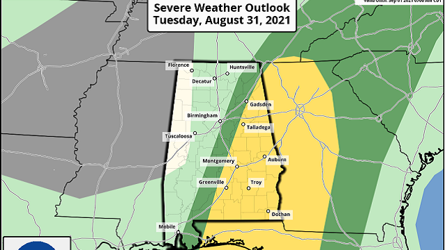
A Flash Flood Watch remains in effect for most of Alabama; additional rain amounts of around 1 inch are likely today. Of greater concern is the potential for a few brief, isolated tornadoes over the eastern and southern counties this afternoon. The Storm Prediction Center maintains a slight risk (level 2 of 5) today for areas east of a line from Fort Payne to Talladega to Prattville to Brewton.
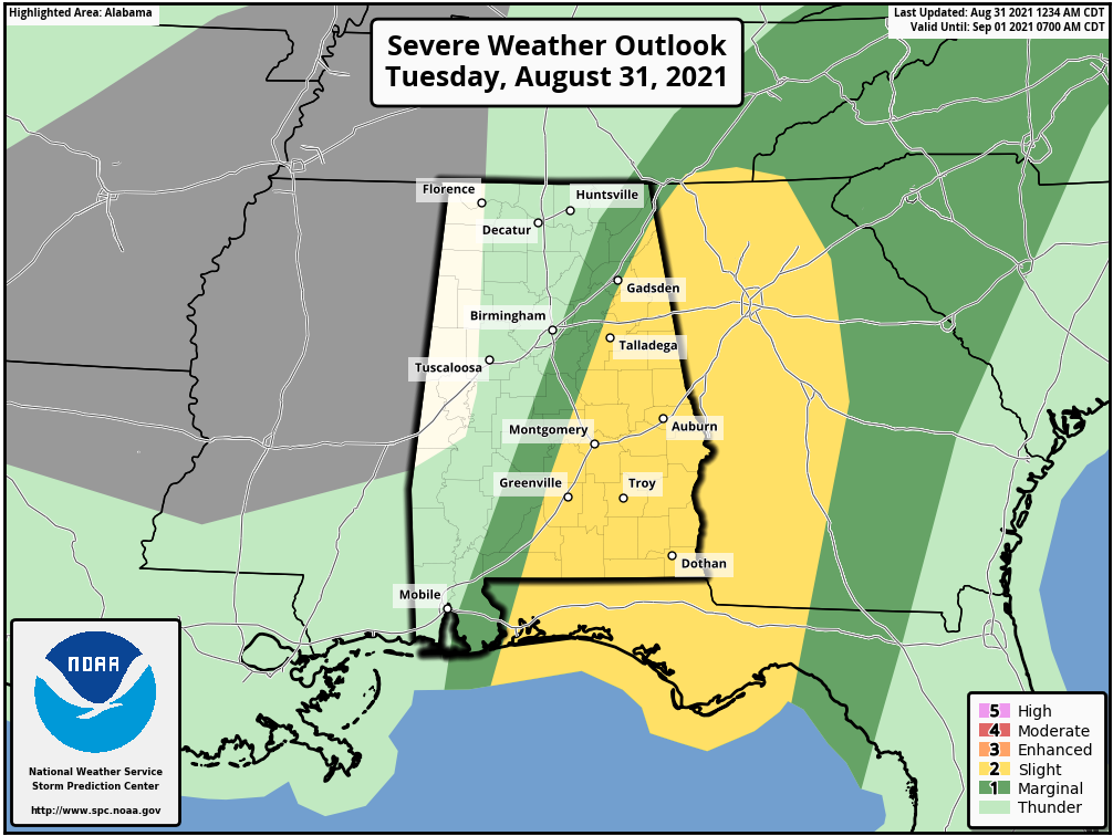
The greatest chance of isolated tornadoes will come roughly from 11 a.m. until 6 p.m. over east and south Alabama. Like the ones Monday, they will most likely be short-lived, and sometimes these tropical tornadoes can get down with little or no warning, so be weather aware today.
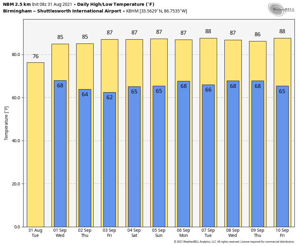
Rain ends for most of the state this evening as Ida lifts away from the region. Wednesday will be mostly dry, with just the chance of a few lingering showers early in the day. The sky becomes partly sunny with a high in the low 80s.
THURSDAY THROUGH THE HOLIDAY WEEKEND: A very dry air mass will settle into the state, setting the stage for some amazingly nice weather Thursday through the long Labor Day weekend. We expect sunny, warm days; clear, pleasant nights, and lower humidity all five days. Highs will be mostly in the upper 80s, with lows in the 60s. However, cooler spots across north and central Alabama will likely drop into the 50s early Thursday and Friday morning for a nice touch of fall.
REST OF NEXT WEEK: Moisture slowly returns Tuesday, but for now we will mention only a few isolated showers Tuesday through Friday. Otherwise, look for partly sunny days and mostly fair nights with highs holding in the 80s.
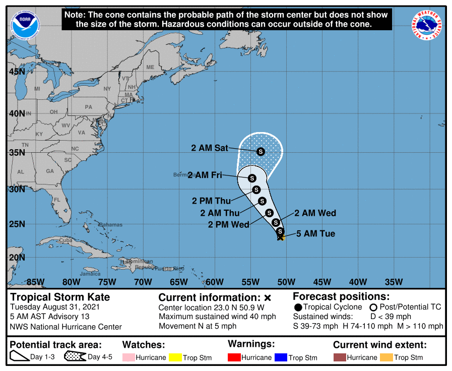
TROPICS: Tropical Storm Kate is a weak, highly sheared tropical storm in the middle of the Atlantic. It will stay weak and far from land.
A well-organized tropical wave has emerged off the coast of Africa; there is a high chance this becomes Tropical Storm Larry within the next day or two, but it will be gaining latitude and will recurve into the open Atlantic far east of the U.S.
A broad area of low pressure is forecast to develop over the southwestern Caribbean Sea in a couple of days. Environmental conditions appear to be somewhat conducive for slow development by the end of the week, as long as the system remains over water. This system is expected to move gradually west-northwestward or northwestward at 5 to 10 mph toward Central America.
There are no tropical systems threatening the central Gulf Coast through the Labor Day weekend.
ON THIS DATE IN 1886: A magnitude 7.3 earthquake shook Charleston, South Carolina, around 9:50 p.m. This earthquake is the most damaging quake to occur in the southeastern United States. It caused 60 deaths and $5 million to $6 million in damage to more than 2,000 buildings.
BEACH FORECAST: Click here to see the AlabamaWx Beach Forecast Center page.
WEATHER BRAINS: You can listen to our weekly 90-minute show any time on your favorite podcast app. This is the show all about weather featuring many familiar voices, including the meteorologists at ABC 33/40.
CONNECT: You can find me on the major social networks:
For more weather news and information from James Spann and his team, visit AlabamaWx.


